

Ready to explore Fort Mountain, Maine? Here's everything you need to know before you go!
Discover the trail

Trail description
Description
Fort Mountain rises out of the deep wilderness of Aroostook County, offering one of the more substantial mountain experiences you'll find in Maine's far north. The trail covers 5.79 kilometers with a serious elevation gain of 1,179 meters, and while it's rated moderate, that gain is real — plan on roughly 2 hours and 45 minutes of focused hiking. What makes Fort Mountain worth the effort isn't just the summit payoff, though that's considerable. It's the combination of rugged terrain, genuine wildlife, and historical remnants scattered along the route that keeps the experience interesting from start to finish.
Terrain and Trail Character
The trail wastes no time getting into the climb. From the trailhead, you're moving upward through dense mixed forest where hardwoods and softwoods share the canopy, filtering light down to a forest floor that stays cool even on warmer days. The lower sections are the most forgiving, with natural contours guiding the path in a way that makes the grade feel manageable. As you gain elevation, the trail tightens and the forest composition shifts — the hardwoods thin out and the softwoods take over, a reliable sign that you're making real progress toward the upper mountain.
The sustained elevation gain is the defining characteristic of this hike. Switchbacks help break up the steeper pitches, but there's no getting around the fact that 1,179 meters of gain over 5.79 kilometers demands consistent effort. Footing is generally solid, but varied — expect rooted sections through the forested stretches and rockier ground as you approach the summit. Trekking poles are worth bringing if you use them, particularly on the descent when tired legs meet uneven terrain.
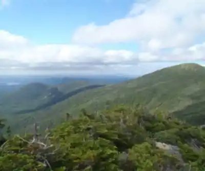
The summit itself is the reward that justifies the work. Views open up across a vast stretch of northern Maine wilderness — rolling forested hills extending in every direction, with very little sign of development to interrupt the horizon. Aroostook County is one of the least densely populated regions in the entire northeastern United States, and from the top of Fort Mountain, that remoteness becomes visually obvious. It's the kind of view that resets your sense of scale.
Wildlife and Natural Features
Fort Mountain's ecosystem is active and diverse. Deer are a regular presence on the trail, most often spotted in the early morning or toward dusk when they move more freely. Foxes inhabit the area as well, though they tend to stay out of sight — slow, quiet movement gives you the best chance of an encounter. Bird activity is consistent throughout the trail, with species varying by elevation zone. The forest sections produce their own soundtrack of calls and movement, and patient observers tend to spot species that don't show up in more trafficked hiking areas.
The changing vegetation zones as you climb add ecological interest beyond the wildlife. The transition from mixed forest to higher-elevation softwood stands happens gradually, but it's noticeable if you're paying attention. Each zone supports its own set of species and creates different conditions underfoot and overhead. Photographers will find the variety useful — intimate forest compositions in the lower sections, wider landscape shots as the canopy opens near the summit.
Historical Remnants
One of the things that sets Fort Mountain apart from other trails in the region is the presence of stone structures along the route. These formations are old enough that their exact origins remain a subject of debate — some researchers point to early European settlers who recognized the strategic value of the elevated position, while other evidence suggests possible Indigenous origins. Neither theory has been definitively settled, which gives the structures an added layer of interest.
Encountering these remnants mid-hike creates natural pause points where the physical effort of climbing gives way to something more reflective. The structures are integrated into the landscape in a way that feels organic rather than staged — they've been there long enough that the forest has grown around and through them. Taking a few minutes to look closely at the stonework and consider who built it, and why, adds a dimension to the hike that purely scenic trails don't offer.
Planning Your Hike
The moderate rating is accurate for hikers who have some experience with sustained climbs, but it shouldn't be taken lightly. The elevation gain is the main factor — 1,179 meters is significant, and the trail doesn't distribute it gently. If you're newer to mountain hiking or haven't been out much recently, build in extra time and take breaks as needed. The estimated 2 hours and 45 minutes is a reasonable target for hikers moving at a steady pace, but the summit views and historical features are worth slowing down for.
- Footwear: Sturdy hiking boots with ankle support are the right call given the elevation gain and the rocky upper sections.
- Water and food: Carry more than you think you need. The physical output on a climb like this depletes you faster than flat trail hiking, especially in warmer conditions.
- Layers: Summit temperatures in Aroostook County can drop noticeably compared to the trailhead, regardless of the season. A packable mid-layer is worth the minimal extra weight.
- Weather: Northern Maine weather moves fast. Check conditions before you head out and be prepared to adjust your plans if the forecast shifts.
- Camera: Whether you're shooting wildlife in the forest or landscapes from the summit, you'll want one.
Fort Mountain sits in a part of Maine that most hikers from southern New England never reach, which means the trails here see a fraction of the traffic that more accessible peaks attract. That relative solitude is part of the appeal — you're unlikely to be sharing the summit with a crowd, and the wilderness character of the surrounding landscape feels genuinely intact. For hikers willing to make the drive into Aroostook County, Fort Mountain delivers a complete mountain experience that holds up well against more famous destinations in the state.
Recommended gear for this trail


Ready to go?
Everything you need to know before you goStarting Point
The trails at the fort mountain, maine can be accessed from the parking lot on the east side of the mountain.
When?
How much?
- Hiking shoes Essential
- → Salomon Elixir Tour Mid WP · 203.38 $
- Layered clothing Essential
- Rain jacket Essential
- Trekking poles
- → Black Diamond Trail Ergo Cork · 69.99 $
- Headlamp
- → Petzl Actik Core 625 · 103.95 $
FAQ - Frequently asked questions
Everything you need to knowThe Essential Hiking Checklist
Everything you need for your next hike. Bilingual, printable, 1 page.
Download the free checklistSimilar hikes nearby
Discover other trails you might enjoy

South Peak
Aroostook County
Allagash Mountain
Aroostook County
Penobscot River Trails
Aroostook County
Fish River
Aroostook County
Deboullie Public Reserved Land
Aroostook County
Grand Falls
Aroostook County
Hiking near Bangor
0 trails to explore ~130 km away
We work hard to provide the most up-to-date and error-free data possible. If something seems incorrect, let us know! Your contribution helps the whole community.
Hikers' opinions