

Ready to explore South Peak? Here's everything you need to know before you go!
Discover the trail
Oh no! We don't have any photos 😢
This trail hasn't been captured yet. Be the first to share your adventure!Trail description
Description
South Peak in Aroostook County offers hikers a rewarding mountain experience that showcases the diverse beauty of Maine's northern wilderness. This moderate 2-kilometer trail leads to a summit marked by a prominent cairn, providing an excellent vantage point for taking in sweeping views of the surrounding landscape. The 330-meter elevation gain makes this hike accessible to adventurers of varying experience levels while still delivering a satisfying challenge that can be completed in about an hour and twenty-five minutes.
Trail Experience and Terrain
The journey to South Peak's summit takes hikers through a remarkable variety of ecosystems that change as you gain elevation. The trail begins in dense forest where towering trees create a natural canopy overhead, filtering sunlight and providing cool shade during warmer months. As you progress upward, the forest gives way to open meadows where wildflowers bloom seasonally and offer the first glimpses of distant peaks and valleys.
The final approach to the summit transitions into rocky ridges that require more careful footing but reward hikers with increasingly dramatic views. These exposed sections showcase the rugged character of Maine's mountains, with weathered granite formations and hardy alpine vegetation clinging to the slopes. The terrain variety keeps the hike engaging throughout, as each ecosystem presents its own unique sights, sounds, and natural features.
Despite the moderate rating, hikers should come prepared for the steady climb. The trail maintains a consistent upward trajectory that builds leg strength and gets your heart pumping without becoming overwhelming. Good hiking boots with ankle support are essential, particularly for navigating the rocky sections near the summit where loose stones and uneven surfaces demand careful attention to foot placement.
Wildlife and Natural Features
South Peak provides excellent opportunities for wildlife observation throughout the hiking experience. Moose are commonly spotted in the lower elevations and meadow areas, particularly during early morning and evening hours when they venture out to feed. White-tailed deer frequent the forest sections and meadow edges, often allowing patient hikers to observe them from a respectful distance.
Black bears also inhabit this region, making proper food storage and awareness essential for all visitors. While bear encounters are relatively rare, hikers should make noise while traveling through dense forest sections and know how to respond appropriately if they do encounter these impressive animals. The diverse habitat supports numerous smaller wildlife species as well, including various bird species, small mammals, and seasonal migrant animals that add to the area's natural appeal.
The changing vegetation zones create distinct micro-environments that support different species at various elevations. The forest floor teems with ferns, mosses, and seasonal mushrooms, while the meadow sections burst with native wildflowers during peak growing season. Near the summit, hardy shrubs and grasses demonstrate nature's ability to thrive in harsh, wind-exposed conditions.
Summit Experience
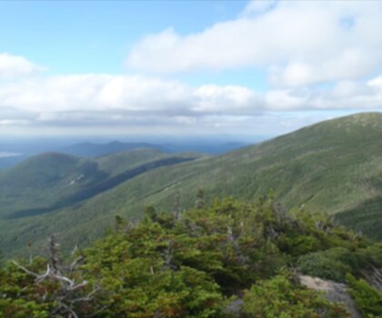
The large cairn marking South Peak's summit serves as both a navigational landmark and a natural gathering spot for hikers to rest and enjoy the panoramic views. From this elevated position, the surrounding Aroostook County landscape unfolds in all directions, revealing the vast forests, distant mountain ranges, and occasional clearings that characterize this remote region of Maine.
The summit area provides ample space for groups to spread out and enjoy lunch while taking in the scenery. The rocky terrain offers natural seating options, and the exposed location typically provides cooling breezes even on warmer days. Photography enthusiasts will find numerous opportunities to capture both wide landscape shots and detailed images of the unique alpine environment.
What strikes many visitors is the sense of vastness visible from the top. The northern Maine wilderness stretches endlessly in every direction, creating a profound connection to the region's wild character. On clear days, the views extend far beyond the immediate area, offering glimpses of the extensive forest network that defines this part of the state.
Planning Your Visit
The compact nature of this hike makes it perfect for those seeking a satisfying mountain experience without committing to an all-day adventure. The moderate difficulty rating reflects the manageable distance combined with steady elevation gain that requires reasonable fitness but doesn't demand technical climbing skills. Most hikers find the challenge level just right for building confidence while still feeling accomplished at the summit.
Weather conditions can change rapidly in this mountain environment, so hikers should come prepared with layers and rain protection regardless of the forecast. The exposed summit area offers little shelter from wind or precipitation, making proper clothing essential for comfort and safety. Even during summer months, temperatures can drop significantly with elevation gain and wind exposure.
Water and snacks are essential, though the relatively short distance means you won't need to carry extensive supplies. Many hikers enjoy bringing a thermos of hot coffee or tea to savor at the summit, especially during cooler months when the warm beverage adds to the mountain experience.
Seasonal Considerations
Each season brings distinct advantages to hiking South Peak, though accessibility and conditions vary significantly throughout the year. Spring offers the excitement of emerging wildflowers in the meadow sections and increased wildlife activity as animals become more active after winter. However, mud season can make trail conditions challenging, and black flies may be problematic during certain periods.
Summer provides the most reliable weather and trail conditions, with fully accessible terrain and the best opportunities for extended summit time. The forest sections offer welcome shade during hot days, while the summit breezes provide natural cooling. Fall transforms the landscape with spectacular foliage colors that enhance the already impressive views, though weather becomes less predictable and daylight hours shorten.
Winter hiking is possible for experienced hikers with proper equipment, but snow and ice significantly increase the challenge level and require snowshoes or microspikes depending on conditions. The winter landscape offers its own stark beauty, but the increased difficulty and shorter daylight hours make this season appropriate only for well-prepared and experienced winter hikers.
What Makes South Peak Special
South Peak stands out in the Aroostook County region for its combination of accessibility and wilderness character. Unlike some more heavily trafficked peaks, this mountain maintains a sense of remoteness and tranquility that allows hikers to feel truly immersed in Maine's northern wilderness. The ecosystem diversity packed into a relatively short hike provides an excellent introduction to the region's natural variety without requiring an extensive time commitment.
The reliable wildlife viewing opportunities set South Peak apart from many other hiking destinations, where animal sightings are often rare or unpredictable. The healthy populations of moose, deer, and other wildlife reflect the area's pristine habitat and effective conservation management. For many visitors, this hike represents their first encounter with Maine's legendary moose population in their natural habitat.
Recommended gear for this trail


Ready to go?
Everything you need to know before you goStarting Point
The easiest way to get to the start of the trails at the south peak is to drive to the summit of South Mountain Road in Carrabassett Valley. There is a small parking lot at the summit where you can park your car. From there, you can hike or ski the trails that lead to the summit of south peak.
When?
How much?
- Hiking shoes Essential
- → Salomon Elixir Tour Mid WP · 203.38 $
- Layered clothing Essential
- Rain jacket Essential
- Trekking poles
- → Black Diamond Trail Ergo Cork · 69.99 $
- Headlamp
- → Petzl Actik Core 625 · 103.95 $
FAQ - Frequently asked questions
Everything you need to knowThe Essential Hiking Checklist
Everything you need for your next hike. Bilingual, printable, 1 page.
Download the free checklistSimilar hikes nearby
Discover other trails you might enjoy

Allagash Mountain
Aroostook County
Penobscot River Trails
Aroostook County
Fish River
Aroostook County
Deboullie Public Reserved Land
Aroostook County
Grand Falls
Aroostook County
Fort Mountain, Maine
Aroostook County
Hiking near Bangor
0 trails to explore ~123 km away
We work hard to provide the most up-to-date and error-free data possible. If something seems incorrect, let us know! Your contribution helps the whole community.
Hikers' opinions