
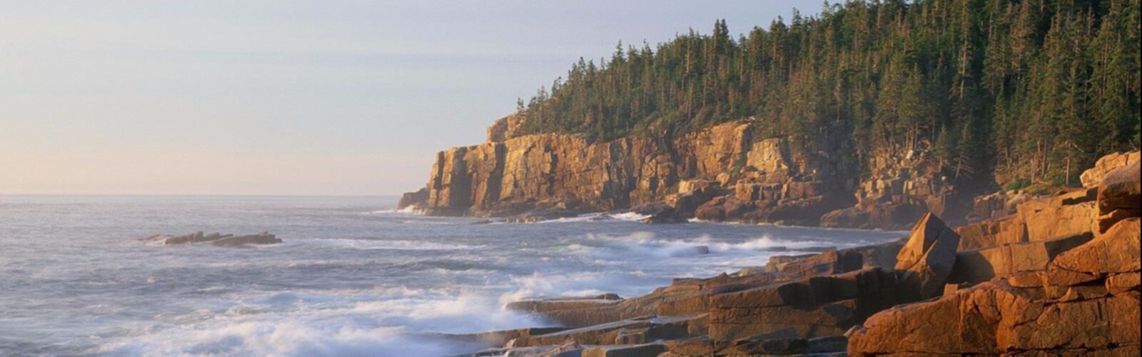

Ready to explore Acadia Mountain, Maine? Here's everything you need to know before you go!
Discover the trail

Available trails
| TrailTrails | Dist.Distance | GainElevation | TimeDuration | Difficulty | GPX |
|---|---|---|---|---|---|
|
|
5.12 km | — | 1h | GPX |
GPX track: © OpenStreetMap contributors — ODbL 1.0
Trail description
Acadia Mountain sits on the western side of Mount Desert Island, offering one of the most satisfying shorter hikes in Acadia National Park. At 4.3 kilometers round-trip with 207 meters of elevation gain, it hits a sweet spot that many hikers are looking for — enough of a climb to feel earned, but nothing that requires a full-day commitment or technical experience. Most people complete the loop in around 2 hours and 15 minutes, making it a realistic half-morning outing even for families or casual hikers.
The trailhead sits off Route 102, with a parking area that handles traffic well outside of peak foliage season in early October. Whether you're based in Bar Harbor, Southwest Harbor, or anywhere else on the island, getting here is straightforward.
On the Trail
The hike starts in classic Maine forest — a mix of hardwoods and conifers that keeps things shaded and cool during summer. The lower sections follow smooth dirt paths with occasional roots and rocks underfoot, nothing that demands scrambling, but enough texture to remind you that you're on a real trail. It's a pleasant warm-up that lets you settle into a rhythm before the terrain changes.
As you gain elevation, granite slabs and boulders start taking over from the forest floor. The rocky sections require you to pay attention to foot placement, especially if there's been recent rain, but they're never technically demanding. The shift in character keeps the ascent interesting — you're not just walking uphill on the same surface the whole way. Around the midpoint, the tree canopy starts to open up, giving you glimpses of what's ahead without fully revealing the summit views. It's a good motivator for the final push.
Summit Views
The payoff at the top is genuinely impressive. Acadia Mountain's summit looks directly out over Somes Sound, which holds the distinction of being the only fjard on the entire East Coast of the United States — a glacially carved inlet that cuts deep into the interior of Mount Desert Island. The view makes the geography of the whole region click into place in a way that maps and driving around don't quite achieve.
On a clear day, you can see well beyond the sound to the eastern peaks of Mount Desert Island and out toward the Atlantic. The summit area has multiple rocky outcrops that work as natural vantage points, so even when other groups are up there, everyone finds their own spot without feeling crowded. It's a good place to sit for a while — the views hold your attention longer than you might expect.
What to Know Before You Go
Footwear matters more than the difficulty rating might suggest. The rocky upper sections can be slippery when wet, and lightweight trail shoes or sneakers with worn tread will make those sections less comfortable and less safe. Shoes with solid grip and some ankle support are the right call here.
There are no water sources on the trail, so bring everything you need. In summer, the combination of exertion and coastal humidity means you'll likely drink more than you expect. Carrying extra is never a bad idea on a trail this short — it adds almost no weight and removes any reason to cut the summit time short.
Coastal Maine weather deserves respect even on a hike this manageable. Fog can move in quickly and reduce visibility significantly, and rain turns the granite slabs into a different experience entirely. Checking the forecast before heading out is worth the two minutes it takes. Wind at the exposed summit can also be stronger than conditions at the trailhead suggest, so an extra layer in your pack is useful even on days that start warm.
How It Fits Into the Broader Area
Acadia Mountain occupies a useful middle ground in the range of hiking options on Mount Desert Island. It's more substantial than a carriage road walk but less committing than the longer or more exposed peaks in the park. That positioning makes it a natural fit for mixed groups, for hikers who want a genuine summit experience without a full-day effort, or for anyone who wants to get a feel for the island's western side before deciding what else to tackle.
The summit view over Somes Sound also gives you a useful orientation to the region's geography — you can see how the various peaks, inlets, and coastal features relate to each other, which adds context to wherever else you plan to explore during your time in the area.
The Essential Hiking Checklist
Everything you need for your next hike. Bilingual, printable, 1 page.
Get your free hiking checklistRecommended gear for this trail
As an Amazon Associate I earn from qualifying purchases.


Ready to go?
Everything you need to know before you goStarting Point
To reach the trailheads for the hiking trails, you can start at the Acadia Mountain Trailhead located on Route 102. The parking lot is situated between Somesville and Southwest Harbor. If you're coming from Bar Harbor, head southwest on Route 233 until it intersects with Route 102, then continue south. The parking area will be on your right. There are no alternative trailheads for this specific hike.
When?
How much?
As an Amazon Associate I earn from qualifying purchases.
Affiliate links — LGPO may earn a commission at no extra cost to you.
- Hiking shoes Essential
- → Salomon Elixir Tour Mid WP · 203.38 $
- Layered clothing Essential
- Rain jacket Essential
- Trekking poles
- → Black Diamond Trail Ergo Cork · 69.99 $
- Headlamp
- → Petzl Actik Core 625 · 103.95 $
FAQ - Frequently asked questions
Everything you need to knowSimilar hikes nearby
Discover other trails you might enjoy
Precipice Trail
Down East & Acadia
Branch Lake Public Forest
Down East & Acadia
Giant's Stairs Trail
Down East & Acadia
St Sauveur Mountain
Down East & Acadia
Valley Peak
Down East & Acadia
Gorham Mountain Trailhead
Down East & Acadia
Hiking near Bar Harbor
0 trails to explore ~12 km away
We work hard to provide the most up-to-date and error-free data possible. If something seems incorrect, let us know! Your contribution helps the whole community.
Hikers' opinions
Be the first to review!
No hiker has shared their experience yet. Share your impressions and help other hikers!