
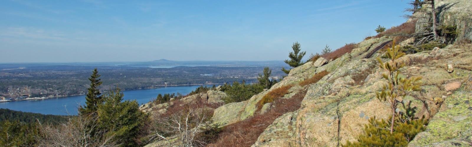

Ready to explore Parkman Mountain, Maine? Here's everything you need to know before you go!
Discover the trail


Trail description
Parkman Mountain sits at 941 feet on Mount Desert Island within Acadia National Park, and it earns its reputation as one of the most satisfying hikes in the region. At 2.9 kilometers with 183 meters of elevation gain, the trail is rated easy and typically takes around two hours and fifteen minutes to complete — enough time to feel like a real mountain experience without burning out your legs before lunch. The summit delivers sweeping views of Somes Sound, the only fjard on the East Coast, along with wide panoramas of the island's forested ridgelines stretching in every direction.
What makes Parkman Mountain stand out in Acadia's crowded lineup of great hikes is the quality of the payoff relative to the effort. You're not grinding up a brutal slog to earn these views — the trail is genuinely approachable, well-marked, and manageable for hikers who are newer to the park or to hiking in general. That said, it doesn't feel like a walk in the park either. The terrain shifts as you climb, and by the time you reach the exposed granite near the top, you'll feel like you've actually done something.
What the Trail Is Like
The Parkman Mountain Trail starts with a gentle climb through mixed forest. The path is clear and easy to follow, with occasional root crossings and small rock steps keeping things interesting without being technical. The lower section has a quiet, enclosed feel — dense spruce and fir overhead, the sound of birds, the smell of damp forest floor. It's a good warm-up that eases you into the hike before the terrain starts asking more of you.
As you gain elevation, the character of the trail changes noticeably. The forest begins to open up, the ground gets rockier, and you start picking your way across granite slabs and around boulders. This is where Acadia's signature geology really shows up. The rock is grippy when dry, but worth treating with respect after rain — wet granite can be slick, and a misstep on an angled slab is no fun. Solid hiking boots with good traction make a real difference here.
About halfway up, you start catching glimpses of Somes Sound through the thinning trees. That first view of the water cutting through the landscape below is one of those moments that reminds you why you drove to Maine in the first place. The final push to the summit involves more exposed rock and a bit of scrambling — nothing that requires hands-and-feet climbing, but enough to keep you engaged and paying attention to your footing.
The summit opens up onto bare granite with multiple natural vantage points. Somes Sound stretches out below, flanked by forested slopes on both sides. On a clear day, you can pick out other Acadia peaks rising from the canopy — each one a potential future hike. There's plenty of flat rock to spread out on, eat a snack, and take your time with the view before heading back down.
Flora, Fauna, and the Landscape
The lower trail passes through typical Maine coastal forest — a mix of spruce, fir, birch, and maple that supports a healthy population of songbirds and small mammals. Chipmunks are a near-constant presence, especially near the trailhead. Higher up, as the tree cover thins and the granite takes over, the vegetation shifts to hardy, low-growing plants adapted to the exposed conditions. It's a noticeable transition that reflects just how different the summit environment is from the forest below.
Wildlife sightings are always a possibility in Acadia, and Parkman Mountain is no exception. Keep your eyes and ears open, especially in the early morning or late afternoon when animal activity tends to peak.
Connecting to Other Trails
Parkman Mountain connects to nearby peaks including Bald Peak and Sargent Mountain, which opens up options for hikers who want to extend their day. The Bald Peak connection adds a different perspective on the surrounding landscape without a huge increase in distance. Sargent Mountain is a more substantial extension — it's one of Acadia's higher summits and rewards the extra effort with even broader views. These connections make Parkman Mountain a flexible starting point: you can keep it short and sweet, or use it as the first leg of a longer loop depending on how much time and energy you have.
Getting There and Practical Details
The trailhead is located off Route 233 (Eagle Lake Road) within Acadia National Park, with parking available nearby. Acadia requires an entrance fee, so make sure you have your pass sorted before you arrive. Parking in the park can fill up quickly during peak season, especially on summer weekends — arriving early in the morning is the most reliable way to avoid the scramble for a spot.
- Distance: 2.9 km
- Elevation gain: 183 m
- Difficulty: Easy
- Estimated time: 2h15
- Trailhead access: Off Route 233 (Eagle Lake Road), Acadia National Park
Wear proper hiking boots — the granite sections reward good traction and ankle support. Bring enough water for the full round trip, and pack a snack for the summit. A rain layer is worth throwing in your pack regardless of the forecast; weather on Mount Desert Island can shift quickly, and the exposed upper section of the trail offers no shelter.
Seasonal Notes
Late spring through early fall is the most comfortable window for hiking Parkman Mountain. Summer brings long days and warm temperatures, ideal for taking your time on the summit. Fall is genuinely spectacular — the mixed forest below the treeline turns through a full range of reds, oranges, and yellows, and the contrast with the bare granite and blue water views is hard to beat. Winter hiking is possible for those with the right gear and experience, but the exposed rock sections require crampons or microspikes when iced over, and conditions should be checked carefully before heading out.
Spring can be muddy in the lower sections as snowmelt works through the soil, so trail-friendly footwear and a willingness to get your boots dirty will serve you well if you're visiting before things dry out in late May or June.
The Essential Hiking Checklist
Everything you need for your next hike. Bilingual, printable, 1 page.
Get your free hiking checklistRecommended gear for this trail
As an Amazon Associate I earn from qualifying purchases.


Ready to go?
Everything you need to know before you goStarting Point
To access the hiking trails, you can start at the Parkman Mountain parking area located on Route 198. Another option is to begin at the trailhead near the intersection of Route 233 and Route 3, where there is additional parking available.
When?
How much?
As an Amazon Associate I earn from qualifying purchases.
Affiliate links — LGPO may earn a commission at no extra cost to you.
- Hiking shoes Essential
- → Salomon Elixir Tour Mid WP · 203.38 $
- Layered clothing Essential
- Rain jacket Essential
- Trekking poles
- → Black Diamond Trail Ergo Cork · 69.99 $
- Headlamp
- → Petzl Actik Core 625 · 103.95 $
FAQ - Frequently asked questions
Everything you need to knowSimilar hikes nearby
Discover other trails you might enjoy
Precipice Trail
Down East & Acadia
Branch Lake Public Forest
Down East & Acadia
Giant's Stairs Trail
Down East & Acadia
St Sauveur Mountain
Down East & Acadia
Valley Peak
Down East & Acadia
Gorham Mountain Trailhead
Down East & Acadia
Hiking near Bar Harbor
0 trails to explore ~9 km away
We work hard to provide the most up-to-date and error-free data possible. If something seems incorrect, let us know! Your contribution helps the whole community.
Hikers' opinions
Be the first to review!
No hiker has shared their experience yet. Share your impressions and help other hikers!