

Ready to explore Doubletop Mountain, Maine? Here's everything you need to know before you go!
Discover the trail

Trail description
Description
Doubletop Mountain sits inside Baxter State Park in Piscataquis County, Maine, and lives up to its name with two distinct summits: a north peak at 3,489 feet and a south peak at 3,455 feet. At 22 kilometers round trip with over 1,000 meters of elevation gain, this is a full-day commitment that earns its very hard rating. If you're looking for a serious wilderness hike in Maine that delivers genuine challenge and variety, Doubletop delivers on both counts.
Getting to the Trailhead
Two separate routes access the mountain, and they offer meaningfully different experiences rather than just different starting points.
The northern approach begins at Nesowednehunk Campground and covers 3.1 miles to the north peak. From there, it's another 0.2 miles to reach the south peak. This is the more gradual of the two routes and a reasonable choice if you want to take in both summits without front-loading the hardest terrain.
The southern approach starts from Foster Field and runs 4 miles to the summit. The first stretch is manageable, but the final third of a mile is a different story — the trail climbs roughly 900 feet in that short distance. That's a punishing grade that demands solid conditioning and careful pacing. Wet conditions make this section significantly more demanding, so check the forecast before committing to the Foster Field route.
What the Trail Is Actually Like
The lower sections of both routes follow well-established trails through mixed forest, with the terrain gradually asserting itself as you gain elevation. The forest composition shifts as you climb, and the final approaches to each peak have their own distinct character.
The north peak stays heavily wooded all the way to the top. You're in the trees, the views are filtered, and the experience feels more enclosed — in a good way if you appreciate that kind of intimate mountain atmosphere. It's a quieter, more sheltered summit.
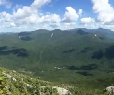
The south peak opens up considerably. The canopy gives way to broader exposure, and the views across Baxter State Park's backcountry are expansive. This is where you'll feel the wind and weather more directly, and where the payoff for the climb becomes most visible. On a clear day, the panorama across the park's wilderness is the kind of view that makes the effort feel entirely worth it.
The Memorial Tablet
Set into the rock face beneath one of the peaks is a bronze memorial tablet facing south. The plaque commemorates Fanny Hall, wife of Keppele Hall, who holds the distinction of being the first American woman to serve as foreman of a grand jury. It's an unexpected piece of history to encounter on a remote Maine summit, and it adds a layer of meaning to the hike that goes beyond the physical challenge.
Planning for the Day
With an estimated 8 hours and 30 minutes on trail and 22 kilometers of distance, this is not a hike to start late or underestimate. The combination of sustained distance, significant elevation gain, and the steep final pitch on the Foster Field route means your body will know it's been somewhere by the end of the day.
Water sources can be limited along both routes, so carry enough for the full duration. The exposed nature of the south peak means conditions can shift quickly, and what starts as a calm morning can turn windy and cold at elevation. Layers, rain gear, and extra food are worth the weight in your pack.
This hike is not suited for beginners. The very hard rating reflects both the physical demands and the remote location within Baxter State Park, where self-sufficiency matters. Come prepared with appropriate footwear, navigation tools, and the fitness to handle sustained steep terrain.
Seasonal Conditions
Baxter State Park sits in central Maine, and Doubletop Mountain sees real seasonal variation. Snow can persist well into spring at higher elevations, and the steep section on the Foster Field route becomes genuinely hazardous when icy. Early season hikers should be prepared for winter-like conditions near the summits even when the lower trails look clear.
Summer offers the most reliable access and the best chance of clear summit views. The south peak's exposure means wind is a factor even on warm days, so don't leave extra layers in the car just because it's July.
What Makes Doubletop Worth the Effort
Most peaks give you one summit experience. Doubletop gives you two that feel genuinely different from each other — the sheltered, wooded north peak and the open, view-rich south peak — within a single outing. That contrast is part of what makes the mountain interesting rather than just difficult.
The location deep within Baxter State Park also means you're not sharing the trail with the crowds that gather on more accessible peaks in the region. The remoteness is part of the experience, and reaching both summits here carries a real sense of wilderness accomplishment that's harder to find on busier mountains.
Recommended gear for this trail


Ready to go?
Everything you need to know before you goStarting Point
The Doubletop Mountain trails are located in the town of Rangeley, Maine. To get to the trails, take Route 4 from Rangeley to the village of Oquossoc. Turn onto Doubletop Mountain Road and drive to the end of the road.
When?
How much?
- Hiking shoes Essential
- → Salomon Elixir Tour Mid WP · 203.38 $
- Layered clothing Essential
- Rain jacket Essential
- Trekking poles
- → Black Diamond Trail Ergo Cork · 69.99 $
- Headlamp
- → Petzl Actik Core 625 · 103.95 $
FAQ - Frequently asked questions
Everything you need to knowThe Essential Hiking Checklist
Everything you need for your next hike. Bilingual, printable, 1 page.
Download the free checklistSimilar hikes nearby
Discover other trails you might enjoy

Chimney Peak, Maine
Maine Highlands

Katahdin
Maine Highlands
Little Spencer Mountain
Maine Highlands
barnard mountain
Maine Highlands
Pleasant Pond Mountain
Maine Highlands
Katahdin Lake
Maine Highlands
Hiking near Bangor
0 trails to explore ~128 km away
We work hard to provide the most up-to-date and error-free data possible. If something seems incorrect, let us know! Your contribution helps the whole community.
Hikers' opinions