

Ready to explore Gulf Hagas Mountain, Maine? Here's everything you need to know before you go!
Discover the trail
Trail description
Description
Gulf Hagas Mountain rises deep in the Maine Highlands, part of a wilderness area that genuinely earns its reputation as one of the most dramatic landscapes in the Northeast. The hike covers 10.3 km with 818 m of elevation gain, rated Very Hard, and most hikers should budget around 4 hours 15 minutes to complete it. This is not a casual outing — the terrain is relentless, the footing demands constant attention, and the remoteness of the area means you need to come prepared.
What draws people out here is the combination of Gulf Hagas itself — a slate gorge carved by the Pleasant River over thousands of years — and the mountain terrain that surrounds it. The gorge has been called the "Grand Canyon of the East," and while that nickname gets thrown around loosely in outdoor circles, the dark slate walls, emerald pools, and cascading waterfalls do justify the comparison in their own right. The mountain adds a physical challenge that transforms what could be a scenic stroll into a genuine backcountry experience.
The Terrain
The trail system here combines rim walking, forest hiking, and genuine mountain climbing into a single outing. You'll move through mixed hardwood and conifer forest, cross root-tangled paths, scramble over granite slabs, and navigate rocky sections along the gorge rim where drop-offs demand full attention. The elevation gain of 818 m is distributed unevenly — expect some sustained climbing that will test your legs and lungs, not just a gradual incline.
The rim sections are the most technically demanding. The rock can be slippery when wet, and the exposure along the gorge edge is real. Trekking poles are worth bringing, especially for the descent. The forest sections offer some relief from the exposure but introduce their own challenges: roots, mud, and uneven footing that slow your pace and tire your feet over the full distance.
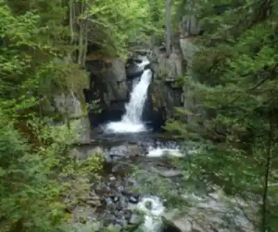
Gulf Hagas Gorge and the Waterfalls
The gorge itself is the visual centerpiece of the entire hike. The Pleasant River has cut through dark slate bedrock to create a channel of dramatic depth, with walls that shift color depending on light and moisture. The water pools below take on shades of emerald and amber that feel almost unreal against the dark stone.
Several named waterfalls punctuate the route. Screw Auger Falls drops through a narrow chute in the bedrock — the water is forced through a tight channel and spirals as it falls, creating a natural formation that's unlike anything else in the region. Buttermilk Falls spreads wider across the rock face, offering multiple angles and a good spot to stop, eat, and take in the scene before continuing. Each waterfall has its own character, and the spacing between them gives the hike a natural rhythm of effort and reward.
Wildlife and Forest
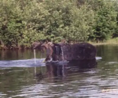
The ecosystem in this part of the Maine Highlands supports a wide range of wildlife. Moose are a genuine possibility, particularly near the wetter areas close to the river — their tracks show up regularly in muddy trail sections. White-tailed deer are common throughout, most active in early morning and late afternoon. The bird life is rich, with warblers moving through the canopy during warmer months and loons audible from nearby ponds.
The forest itself reflects Maine's logging history. Old growth sections mix with areas that have regenerated over the past century, creating a layered habitat with dense fern understory in some sections and open rocky ground in others. The diversity of the forest structure is part of what makes the hike feel varied even when you're deep in the trees.
Trail Connections
Gulf Hagas Mountain sits within reach of Katahdin Iron Works State Park, which provides the primary access point for this area and offers additional hiking options for those planning a multi-day visit. The historic iron works site near the trailhead adds an unexpected layer of context — the industrial remnants in the middle of this wilderness are a striking contrast worth a few minutes of your time.
The Appalachian Trail passes through this region as well, and connections to the AT open up possibilities for longer extensions or multi-day backpacking routes that push deeper into Maine's highland terrain. For a day hike, Gulf Hagas Mountain is already a full commitment — but the infrastructure exists to build something bigger around it if you have the time and the legs.
What to Bring and How to Prepare
The 4h15 estimated duration assumes a solid hiking pace with brief stops. Factor in time at the waterfalls and gorge viewpoints and your day will likely run longer. Start early, especially during summer and fall when the area sees more traffic.
- Footwear: Waterproof hiking boots with ankle support are strongly recommended. The rocky rim sections and potential stream crossings make trail runners a risky choice.
- Water: Carry more than you think you need. The physical demands of 818 m of elevation gain over 10.3 km will push your hydration requirements higher than a typical day hike.
- Layers: Weather in the Maine Highlands shifts quickly. Even in summer, temperatures drop noticeably in the gorge and at elevation. A packable rain layer is worth the weight.
- Navigation: The trail is marked, but the complexity of the route and the remoteness of the area make a downloaded offline map or paper topo a smart backup.
- Timing: Check trail conditions before heading out. Spring snowmelt and fall rain can make the rim sections significantly more hazardous, and the access road to Katahdin Iron Works has seasonal restrictions.
The access fee for Katahdin Iron Works State Park applies to this hike — confirm current rates and hours with Maine DACF before your visit, as these can change seasonally.
Best Seasons
Late spring through early fall covers the main hiking window here. Summer brings the warmest conditions and the fullest water flow in the gorge, making the waterfalls most impressive and the river pools most inviting. Fall is arguably the peak season visually — the hardwood canopy turns against the dark slate of the gorge walls in a contrast that makes this one of the more photogenic hikes in Maine. Winter access is limited and the terrain becomes genuinely dangerous without proper mountaineering equipment.
Whatever season you choose, Gulf Hagas Mountain rewards the effort with scenery and physical challenge that are hard to match anywhere in the Maine Highlands.
Recommended gear for this trail


Ready to go?
Everything you need to know before you goStarting Point
The start of the trails at the gulf hagas mountain, maine can be accessed by taking Route 201 north from Millinocket, Maine. The trailhead is located on the east side of the road, approximately 9 miles north of Millinocket.
When?
How much?
- Hiking shoes Essential
- → Salomon Elixir Tour Mid WP · 203.38 $
- Layered clothing Essential
- Rain jacket Essential
- Trekking poles
- → Black Diamond Trail Ergo Cork · 69.99 $
- Headlamp
- → Petzl Actik Core 625 · 103.95 $
FAQ - Frequently asked questions
Everything you need to knowThe Essential Hiking Checklist
Everything you need for your next hike. Bilingual, printable, 1 page.
Download the free checklistSimilar hikes nearby
Discover other trails you might enjoy

Chimney Peak, Maine
Maine Highlands

Katahdin
Maine Highlands
Little Spencer Mountain
Maine Highlands
barnard mountain
Maine Highlands
Pleasant Pond Mountain
Maine Highlands
Katahdin Lake
Maine Highlands
Hiking near Bangor
0 trails to explore ~93 km away
We work hard to provide the most up-to-date and error-free data possible. If something seems incorrect, let us know! Your contribution helps the whole community.
Hikers' opinions