

Ready to explore Hamlin Peak, Maine? Here's everything you need to know before you go!
Discover the trail

Trail description
Description
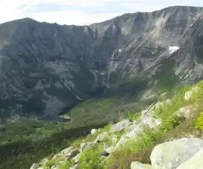
Hamlin Peak rises 4,756 feet above sea level as part of the massive Katahdin range in Maine's Baxter State Park, offering one of the state's most challenging and rewarding hiking experiences. While neighboring Baxter Peak claims the title of Maine's highest point, Hamlin Peak delivers equally spectacular wilderness views with fewer crowds and a distinctly rugged character that appeals to experienced hikers seeking a serious mountain adventure.
This 16.1-kilometer round-trip journey gains 1,450 meters of elevation and typically requires 4 to 6 hours to complete, making it a very hard hike that demands proper preparation and fitness. The route follows the Hamlin Ridge Trail, which provides the most direct access to the summit while showcasing the diverse terrain that makes the Katahdin massif so compelling.
Trail Experience and Terrain
The Hamlin Ridge Trail begins in dense Maine forest, where you'll navigate through towering spruce and fir trees that gradually thin as you gain elevation. The initial miles wind through lush woodland terrain, crossing small streams and rocky sections that hint at the more challenging terrain ahead. This lower section provides excellent opportunities to spot local wildlife, particularly moose and deer that frequent these protected woods.
As you climb higher, the trail transitions onto the exposed ridgeline that gives this route its name. Here, the hiking becomes more technical, requiring careful footing across granite slabs and boulder fields. The rocky ridges demand attention to route-finding, especially in poor weather, but reward hikers with increasingly dramatic views of the surrounding North Woods.
The upper reaches of Hamlin Ridge present true alpine conditions, with weather that can change rapidly regardless of the season. Wind exposure becomes significant as you approach the summit, and the final push involves scrambling over large granite blocks that form the peak's distinctive profile. This section separates Hamlin Peak from easier Maine hikes and contributes to its reputation as a serious mountain objective.
Summit Views and Surroundings
From Hamlin Peak's summit, the panoramic views stretch across Maine's vast North Woods, revealing an unbroken canopy of wilderness that extends to the horizon on clear days. The perspective encompasses the entire Katahdin massif, including nearby Baxter Peak and the dramatic Knife Edge ridge that connects the two summits. To the north and west, countless lakes and ponds dot the forest landscape, while the Penobscot River valley stretches southward toward more populated regions of the state.
The summit itself consists of a broad granite dome with multiple viewpoints, allowing hikers to find shelter from wind while still enjoying the expansive vistas. On exceptionally clear days, the views extend well beyond Baxter State Park's boundaries, encompassing much of northern and central Maine's mountainous terrain.
Essential Preparation and Gear
Sturdy hiking boots with good ankle support are absolutely essential for navigating the rocky terrain safely, particularly on the exposed ridge sections where loose rock and granite slabs create challenging footing. The significant elevation gain and technical terrain make this hike unsuitable for casual footwear or inexperienced hikers.
Weather protection becomes critical due to the exposed nature of the upper trail and summit. Layered clothing allows you to adjust for the dramatic temperature differences between the forested lower elevations and the windswept peak. Even on warm valley days, summit conditions can be surprisingly cold and windy, making insulating layers and wind protection necessary year-round.
Carry plenty of water for this demanding climb, as the physical challenge of gaining nearly 1,500 meters of elevation requires proper hydration. The rocky terrain offers limited natural water sources along the upper portions of the route, making it essential to pack sufficient supplies from the trailhead.
Baxter State Park Context
Hamlin Peak represents just one of many outstanding hiking opportunities within Baxter State Park's 200,000 acres of protected wilderness. The park's trail system offers everything from gentle nature walks to technical alpine routes, making it worth considering additional hikes during your visit. Each trail provides a different perspective on this remarkable landscape, from dense forest environments to exposed mountain terrain.
The park's commitment to preserving Maine's natural character means that facilities remain deliberately minimal, emphasizing the wilderness experience over convenience. This approach creates an authentic backcountry atmosphere that enhances the sense of adventure and connection with the natural environment that draws hikers to places like Hamlin Peak.
The combination of challenging terrain, spectacular views, and genuine wilderness character makes Hamlin Peak a standout destination for serious hikers exploring Maine's mountain country, offering an experience that captures the rugged essence of the state's wild heart while providing memories that extend far beyond the hiking day itself.
Recommended gear for this trail


Ready to go?
Everything you need to know before you goStarting Point
To access the hiking trails, you can start at the Roaring Brook Campground. The address is Baxter State Park, Millinocket, ME 04462. Another option is to begin at the Chimney Pond Trailhead, which is also located within Baxter State Park. Both trailheads provide parking facilities for hikers.
When?
How much?
- Hiking shoes Essential
- → Salomon Elixir Tour Mid WP · 203.38 $
- Layered clothing Essential
- Rain jacket Essential
- Trekking poles
- → Black Diamond Trail Ergo Cork · 69.99 $
- Headlamp
- → Petzl Actik Core 625 · 103.95 $
FAQ - Frequently asked questions
Everything you need to knowThe Essential Hiking Checklist
Everything you need for your next hike. Bilingual, printable, 1 page.
Download the free checklistSimilar hikes nearby
Discover other trails you might enjoy

Chimney Peak, Maine
Maine Highlands

Katahdin
Maine Highlands
Little Spencer Mountain
Maine Highlands
barnard mountain
Maine Highlands
Pleasant Pond Mountain
Maine Highlands
Katahdin Lake
Maine Highlands
Hiking near Bangor
0 trails to explore ~125 km away
We work hard to provide the most up-to-date and error-free data possible. If something seems incorrect, let us know! Your contribution helps the whole community.
Hikers' opinions