

Ready to explore Katahdin, Maine? Here's everything you need to know before you go!
Discover the trail

Trail description
Description
Mount Katahdin stands as Maine's highest peak at 5,267 feet and serves as the dramatic northern terminus of the Appalachian Trail. This massive granite monolith dominates the landscape of Baxter State Park, offering some of the most challenging and rewarding hiking in New England. The mountain features multiple routes to the summit, each presenting its own character and difficulty level, but all demanding respect for the exposed terrain above treeline.
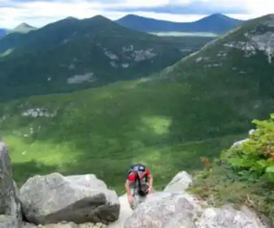
The approach to Katahdin begins at one of three campgrounds within Baxter State Park, each providing access to different trail systems. From Roaring Brook Campground, you can access both the Helon Taylor Trail and routes to Chimney Pond. The Abol Campground serves as the starting point for the Abol Trail, while Katahdin Stream Campground provides access to the Hunt Trail. Regardless of your chosen route, the character of the hike changes dramatically once you break treeline, transitioning from forest paths to rocky terrain that requires careful footing and occasional hands-and-knees scrambling.
The Helon Taylor and Knife Edge Route
The Helon Taylor Trail covers 3.2 miles with 3,413 feet of elevation gain and carries a "very strenuous" rating that should be taken seriously. This route demands excellent weather conditions due to its high exposure rate, and attempting it in poor weather can be dangerous. The trail climbs steeply through increasingly loose rocks and boulders before reaching Pamola Peak, the first major summit on your journey to Katahdin's true peak, Baxter Peak.
Pamola Peak serves as the gateway to the legendary Knife Edge Trail, a 1.1-mile traverse with 365 feet of elevation gain that ranks among the most technical hiking experiences in the eastern United States. The Knife Edge connects Pamola Peak to Baxter Peak across completely exposed terrain that requires intense concentration and agility. This narrow ridge of loose rocks challenges hikers both mentally and physically, with no option to turn back once you've committed to leaving Pamola Peak. The experience of inching across a mile of unstable granite while fully exposed to the elements creates an unforgettable adventure that many describe as one of the most intense experiences of their hiking careers.
Alternative Routes and the Hunt Trail
The Hunt Trail offers a different approach to the summit, covering 5.2 miles with substantial elevation gain. This route begins deceptively with some dirt path segments, but the final mile transforms into a pleasant, gradually sloping approach to the summit. Despite this easier finish, the majority of the ascent involves navigating rocks and boulders with occasional handholds required. A typical round trip on the Hunt Trail takes about 10 hours, including time for breaks and summit photography.
From Chimney Pond, hikers can choose between the Cathedral Trail and the Saddle Trail to reach the upper elevations. The Saddle Trail offers a longer but less steep option with loose-rock terrain, while both routes require roughly the same amount of time to connect with Chimney Pond. The Cathedral Trail provides a more direct but steeper ascent. Many experienced hikers create loop routes, such as ascending via Cathedral Trail to the summit, crossing the Knife Edge, and descending via Helon Taylor back to Roaring Brook.
Summit Experience and Appalachian Trail Connection
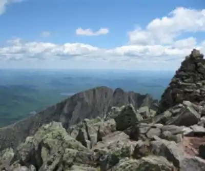
The summit of Mount Katahdin often bustles with activity, particularly during peak season, as hikers gather around the iconic 5,267-foot summit sign for photographs. The mountain holds special significance as the northern terminus of the 2,200-mile Appalachian Trail, and you may encounter thru-hikers completing their epic journey after traversing the challenging Hundred-Mile Wilderness. These encounters add a unique dimension to the summit experience, connecting your day hike to the broader hiking community and the legendary long-distance trail.
Weather conditions can vary dramatically on the exposed upper elevations. Early September climbs may encounter ice-covered rocks on the tablelands, while summer conditions can lead to intense sun exposure and dehydration. The mountain's exposure means that weather can change rapidly, making proper preparation and decision-making crucial for safety.
Planning and Logistics
Access to Katahdin requires advance planning due to Baxter State Park's conservation-focused management approach. The park limits the number of vehicles on the three roadside Katahdin trails to protect natural resources and wildlife. You can reserve parking spaces through the park's reservation system, which is strongly recommended for July and August visits as well as most weekends, when spaces fill quickly.
Reservations must be made at the entrance gate on the morning of your trip, and timing is critical. Arriving before 7:00 AM is essential, as even arriving a few minutes after 7:00 AM can mean missing out on parking. The gate opens early, and being among the first few cars in line significantly improves your chances of securing a parking spot at your desired trailhead.
For overnight stays, camping within Baxter State Park puts you closest to the trailheads for an early morning start. The New England Outdoor Center, located about 45 minutes from the park, offers various cabins and lodges along with views of Millinocket Lake and Mount Katahdin. Downtown Millinocket, approximately one hour from the park, provides additional accommodation options including inns, cottages, lodges, camping facilities, and bed-and-breakfasts.
Preparation and Equipment
Katahdin demands proper equipment, weather preparedness, and excellent decision-making regardless of your chosen route. Water becomes limited after the first mile on most routes, making adequate hydration planning essential. The exposed nature of the upper mountain requires sun protection, and the technical terrain calls for sturdy footwear with good traction. The physical and mental demands of routes like the Knife Edge can reduce your typical hiking pace significantly, from an average of 2 mph to as slow as 0.9 mph, which affects both timing and water consumption calculations.
This mountain has challenged hikers of all ages, including families with teenagers, though the very strenuous rating applies regardless of the route chosen. The combination of technical terrain, weather exposure, and significant elevation gain makes Katahdin a serious undertaking that will test your limits and provide stories you'll share for years after returning home.
Ready to go?
Everything you need to know before you goStarting Point
To access the hiking trails, you can start at the Katahdin Stream Campground, located within Baxter State Park. The address is 64 Balsam Drive, Millinocket, ME 04462. Another option is the Roaring Brook Campground, also in Baxter State Park, with the address 308 Roaring Brook Road, Millinocket, ME 04462. Both locations serve as trailheads for various routes up the mountain.
When?
How much?
- Hiking shoes Essential
- Layered clothing Essential
- Rain jacket Essential
- Trekking poles
- Headlamp
FAQ - Frequently asked questions
Everything you need to knowThe Essential Hiking Checklist
Everything you need for your next hike. Bilingual, printable, 1 page.
Download the free checklistAlternatives and suggestions
Similar hikes nearby
Discover other trails you might enjoy

Chimney Peak, Maine
Maine Highlands

Katahdin
Maine Highlands
Little Spencer Mountain
Maine Highlands
barnard mountain
Maine Highlands
Pleasant Pond Mountain
Maine Highlands
Katahdin Lake
Maine Highlands
Hiking near Bangor
0 trails to explore ~123 km away
We work hard to provide the most up-to-date and error-free data possible. If something seems incorrect, let us know! Your contribution helps the whole community.
Hikers' opinions