

Ready to explore Mount Chase, Maine? Here's everything you need to know before you go!
Discover the trail

Trail description
Description
Mount Chase rises 2,440 feet above the forests of Penobscot County, making it one of the more rewarding summit hikes in Maine's Highlands region. What makes this mountain stand out is the combination it offers: a genuine wilderness feel, a manageable 3.2-kilometer route, and panoramic views that pay off the 744-meter elevation gain in full. This isn't a crowded trailhead experience — it's the kind of hike where you're likely to have long stretches entirely to yourself.
The estimated 2.5-hour round trip makes Mount Chase a realistic half-day outing for hikers with a basic level of fitness and experience. Despite being rated easy, the elevation gain is real and steady, so don't let that label lead you to underestimate the climb. Come prepared, move at your own pace, and the summit will take care of the rest.
The Climb: What to Expect Underfoot
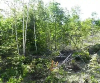
The trail starts in dense mixed forest, the kind of canopy that's characteristic of this part of Maine — a blend of hardwoods and conifers that keeps things shaded and cool in the lower sections. The grade is consistent without being punishing, and the path is generally well-marked throughout.
Underfoot, expect the standard Maine trail experience: exposed roots, rocks of varying sizes, and sections that can get muddy after rain. Good ankle support matters here. Trail runners work for experienced hikers who know their footing, but most people will be more comfortable in proper hiking boots with solid traction. The terrain isn't technical — there's no scrambling or route-finding involved — but it does demand attention, especially on the descent when tired legs are more likely to catch on a root.
As you gain elevation, the forest composition shifts noticeably. The hardwood mix gives way to more coniferous cover, and the understory opens up. You'll start catching glimpses of the terrain ahead through the trees before the trail delivers you to the summit proper. The final section steepens compared to the lower trail, but it remains well within reach for anyone who's been moving comfortably up to that point.
Wildlife and Forest Environment
The relatively light traffic on Mount Chase is one of its genuine advantages for anyone interested in wildlife. Deer are commonly spotted along the trail, particularly during early morning and late afternoon hours when they're most active. The bird life throughout the forest is consistent and varied — you'll hear species calling throughout the climb even when you can't spot them through the canopy.
Because the trail doesn't see heavy use, the ecosystem here feels largely undisturbed. That's worth appreciating, and it also means your presence has a more noticeable impact than it would on a busier mountain. Make noise in sections with limited sightlines, keep food secured, and give any wildlife you encounter plenty of space. These aren't just guidelines — they're what keeps this kind of experience available for the next person who comes through.
The Summit
The open summit of Mount Chase delivers a full 360-degree view across the rolling forested landscape of Maine's Highlands. On a clear day, other peaks are visible in the distance, and the sense of scale — just how much unbroken forest stretches out in every direction — is genuinely striking. The summit area is spacious enough to spread out, eat lunch, and take your time without feeling cramped.
For photography, the summit works best during the golden hours — early morning light or the hour before sunset — when the forested valleys below take on depth and color. That said, midday visits still offer strong views; the open exposure just means harsher light for photos.
The summit vegetation, while it may look sparse, is fragile. Alpine and sub-alpine plant communities recover slowly from foot traffic. Stick to established paths and rock surfaces when you're moving around up top, and resist the urge to wander onto vegetated areas just for a slightly better angle.
Planning Your Visit
The 2.5-hour estimate is a reasonable target for hikers moving at a moderate pace with short breaks included. Stronger hikers will likely come in under that; anyone taking extended breaks at the summit or moving cautiously on technical sections should plan for more time. Either way, this is a hike that fits comfortably into a morning or afternoon without requiring an early alpine start.
- Footwear: Hiking boots with ankle support and solid traction are the right call for Maine trail conditions.
- Water: Water sources along the trail are limited — carry enough for the full round trip.
- Layers: Weather in the Maine Highlands can shift quickly. Even on warm days, bring a layer for the summit where wind exposure is real.
- Timing: Early morning starts give you the best chance at wildlife sightings and the best light for summit photography.
Leave No Trace
Mount Chase's light trail traffic is part of what makes it worth visiting — and it's also exactly why Leave No Trace practices matter more here than on a heavily managed, high-traffic peak. Pack out everything you bring in. Stay on the designated trail to avoid erosion and vegetation damage. Keep noise levels reasonable, especially in areas where wildlife is likely present. The mountain's natural character is directly tied to how visitors treat it, and with lower foot traffic, each individual visit carries more weight.
The forest ecosystem you move through on this hike represents a complex, long-established community of plants and animals adapted to Maine's specific climate and terrain. Leave rocks, plants, and natural objects where you find them, observe wildlife from a distance, and resist feeding any animals you encounter — even the ones that seem comfortable around people.
Recommended gear for this trail


Ready to go?
Everything you need to know before you goStarting Point
To access the hiking trails, you can start at the trailhead located at the parking area on Mountain Road. The address for this trailhead is 528 Mountain Road, Patten, ME 04765. This is the primary access point for hikers.
When?
How much?
- Hiking shoes Essential
- → Salomon Elixir Tour Mid WP · 203.38 $
- Layered clothing Essential
- Rain jacket Essential
- Trekking poles
- → Black Diamond Trail Ergo Cork · 69.99 $
- Headlamp
- → Petzl Actik Core 625 · 103.95 $
FAQ - Frequently asked questions
Everything you need to knowThe Essential Hiking Checklist
Everything you need for your next hike. Bilingual, printable, 1 page.
Download the free checklistSimilar hikes nearby
Discover other trails you might enjoy

Chimney Peak, Maine
Maine Highlands

Katahdin
Maine Highlands
Little Spencer Mountain
Maine Highlands
barnard mountain
Maine Highlands
Pleasant Pond Mountain
Maine Highlands
Katahdin Lake
Maine Highlands
Hiking near Fredericton
11 trails to explore ~143 km away
We work hard to provide the most up-to-date and error-free data possible. If something seems incorrect, let us know! Your contribution helps the whole community.
Hikers' opinions