

Ready to explore Mount Coe, Maine? Here's everything you need to know before you go!
Discover the trail
Trail description
Description
Mount Coe rises 3,795 feet above sea level in the heart of Baxter State Park, and it earns its reputation as one of Maine's most demanding hikes. At 17.5 km round trip with 1,157 meters of elevation gain, this is not a trail you wander onto unprepared. The estimated 6 hours and 15 minutes reflects a solid, steady pace — and that's assuming good conditions and a confident scrambler on the technical sections.
The mountain sits within Baxter State Park's protected wilderness, where strict conservation policies keep the landscape in its natural state. It's part of the same rugged terrain that defines northern Maine's backcountry character — remote, unforgiving, and genuinely spectacular when the weather cooperates.
Trail Character and Terrain
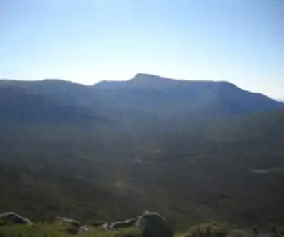
The hike starts in dense northern forest, moving through mixed stands of hardwood and conifer where the trail is well-defined and the grade is manageable. That changes as you gain elevation. The upper sections are rocky, steep, and demand your full attention. You're stepping over exposed roots, navigating around boulders, and reading the terrain constantly. This isn't a trail where you can zone out and enjoy the scenery while walking — the terrain keeps you honest.
The standout feature is the Coe Slide, a steep exposed granite face that requires hands-and-feet scrambling. It's the section that separates hikers who've done technical terrain before from those who haven't. On dry rock with good footwear, it's challenging but manageable for experienced hikers. On wet rock, it becomes genuinely dangerous. The slide also opens up your first real views of the surrounding wilderness, which makes the effort feel worthwhile even before you reach the top.
Above the slide, the trail continues through increasingly open terrain, with exposed bedrock, glacial erratics, and low-growing vegetation replacing the forest canopy. The final push to the summit involves more scrambling and some route-finding on the rocky upper slopes.
Summit Views
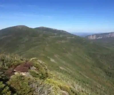
The summit delivers the kind of panoramic views that justify a very hard rating. To the south, Mount Katahdin dominates the skyline — Maine's highest peak is unmistakable from this vantage point. The rest of the view is a vast sweep of northern Maine wilderness: unbroken forest, distant ridgelines, and the lakes and streams that thread through the valleys below. The Traveler Range's other peaks are visible from here, giving you a clear sense of the terrain you're moving through.
Wind exposure at the summit is significant. Even on a warm day at the trailhead, summit conditions can be considerably colder and windier. Pack layers regardless of the forecast.
Wildlife and Natural Environment
The lower elevations of Mount Coe support the wildlife you'd expect from Maine's boreal backcountry. Moose are present in the area, particularly near wetlands and forest clearings in early morning and evening. Black bears inhabit the region. The forest transitions from northern hardwoods — maple, birch, beech — to spruce and fir as you gain elevation, with alpine vegetation appearing near the summit where soils are thin and conditions are harsh.
Bird life includes ravens, gray jays, and various woodpecker species typical of Maine's boreal forests. Hawks and eagles occasionally work the thermals above the ridgelines.
Extended Options: The Traveler Loop
Mount Coe connects to a larger multi-peak route that takes in South Brother and North Brother mountains. This extended loop is a serious undertaking that requires strong fitness, careful planning, and a realistic assessment of your pace. It's the kind of objective that experienced hikers in the area build a full day — or a multi-day trip — around. Each peak adds its own character and perspective, and the connecting ridgelines offer additional viewpoints across the wilderness.
Gear and Preparation
Sturdy hiking boots with solid ankle support and aggressive tread are essential on this terrain. The granite surfaces on the Coe Slide and upper slopes demand reliable grip, and worn-out soles are a liability. Trekking poles help significantly on the steep descents, where the rocky terrain puts real stress on knees and ankles.
Carry more water than you think you need. The physical demands of this hike are substantial, and natural water sources along the route may require significant detours to access. High-calorie snacks help sustain energy through the long ascent and the equally demanding return trip.
Weather in Baxter State Park's mountains changes quickly. Check the forecast before you go, but plan for conditions to be worse than predicted — especially at elevation. Rain gear, an insulating layer, and wind protection belong in your pack even in summer.
Be honest with yourself about the Coe Slide. If you're uncomfortable with exposed scrambling or if the rock is wet, turning back is the right call. The mountain will be there on a better day.
Access and Park Information
Mount Coe is accessed through Baxter State Park, which has its own entry requirements, reservation system, and regulations. The park operates under strict conservation guidelines that limit visitor numbers and prohibit certain activities to protect the wilderness character of the area. Check Baxter State Park's official resources for current access information, trailhead parking details, and any reservation requirements before your visit.
Recommended gear for this trail


Ready to go?
Everything you need to know before you goStarting Point
To access the hiking trails, head to the parking lot located at the end of Slide Dam Road in Baxter State Park. This is the primary trailhead for the area. Ensure you have a park pass and check any seasonal road conditions or closures before your visit.
When?
How much?
- Hiking shoes Essential
- → Salomon Elixir Tour Mid WP · 203.38 $
- Layered clothing Essential
- Rain jacket Essential
- Trekking poles
- → Black Diamond Trail Ergo Cork · 69.99 $
- Headlamp
- → Petzl Actik Core 625 · 103.95 $
FAQ - Frequently asked questions
Everything you need to knowThe Essential Hiking Checklist
Everything you need for your next hike. Bilingual, printable, 1 page.
Download the free checklistSimilar hikes nearby
Discover other trails you might enjoy

Chimney Peak, Maine
Maine Highlands

Katahdin
Maine Highlands
Little Spencer Mountain
Maine Highlands
barnard mountain
Maine Highlands
Pleasant Pond Mountain
Maine Highlands
Katahdin Lake
Maine Highlands
Hiking near Bangor
0 trails to explore ~127 km away
We work hard to provide the most up-to-date and error-free data possible. If something seems incorrect, let us know! Your contribution helps the whole community.
Hikers' opinions