
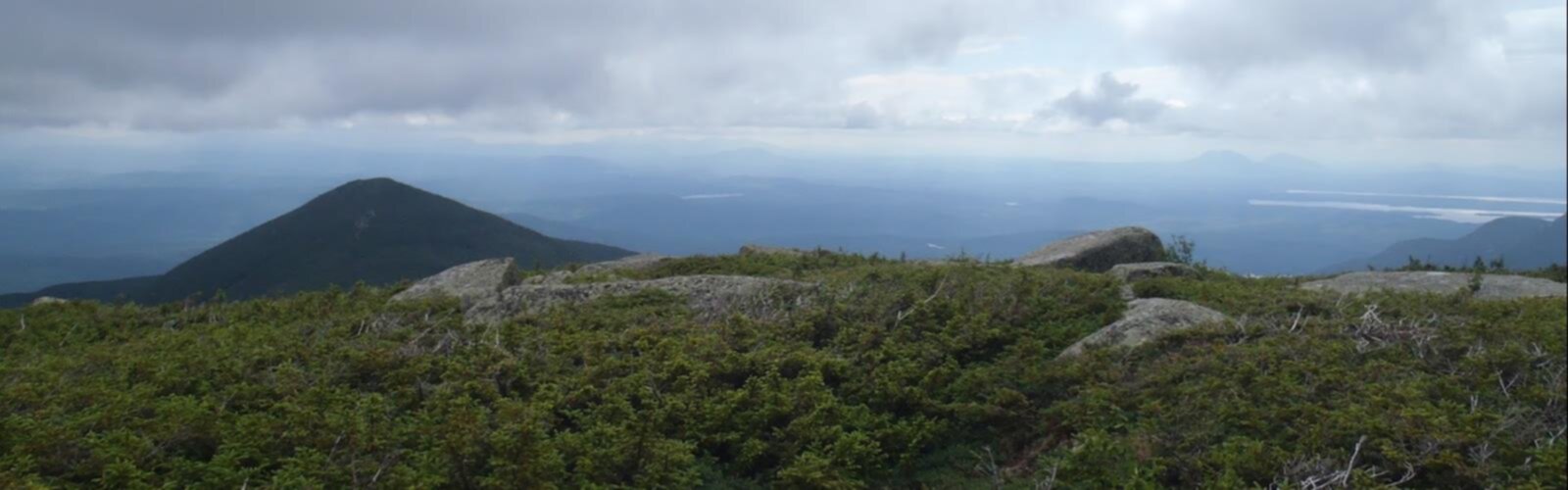

Ready to explore North Brother, Maine? Here's everything you need to know before you go!
Discover the trail


Trail description
North Brother is a rugged mountain in Baxter State Park, located in Piscataquis County in the Maine Highlands. It sits within one of the most remote and wild corners of the northeastern United States, flanked to the northeast by Fort Mountain and to the southwest by South Brother — the two peaks together known as The Brothers. This is serious backcountry terrain, and the hike reflects that.
The Trail
The route to North Brother covers 15.4 km with 1,265 m of elevation gain, and most hikers should plan for around 6 hours and 15 minutes on the trail. It's rated moderate, though that rating deserves some context: the terrain in Baxter State Park is consistently demanding, and the remoteness of North Brother means you're committing to a full day in the wilderness with limited bailout options. Come prepared.
The mountain's drainage tells you a lot about its geography. The south and east slopes shed water into a low, swampy area known as The Klondike, which drains into Wassataquoik Stream, then into the East Branch of the Penobscot River, and eventually out to Penobscot Bay. The north and west sides drain into Little Nesowadnehunk Stream, Nesowadnehunk Stream, and the West Branch of the Penobscot River. That divide — right underfoot as you climb — is a reminder of just how deep into Maine's watershed you are.
The Setting
Baxter State Park is a place that operates on its own terms. There are no crowds, no cell service, and no shortcuts. North Brother sits roughly 8 km (5 miles) northwest of Mount Katahdin, the northern terminus of the Appalachian Trail — a 3,490 km National Scenic Trail stretching all the way to Georgia. Katahdin dominates the skyline from the upper reaches of North Brother, and on a clear day the views across the park are expansive and genuinely impressive.
The Klondike, visible from the upper trail, is one of the more striking features of this corner of the park — a broad, boggy wilderness basin that sees very little foot traffic and gives the landscape a raw, untouched feel. It's the kind of view that reminds you why people make the effort to get out here.
What to Expect on the Hike
The trail gains elevation steadily, with the upper sections becoming more exposed as you approach the summit. The footing can be rocky and uneven throughout, and wet conditions — common in the Maine Highlands — make traction a real consideration. Waterproof boots and trekking poles are worth bringing.
Wildlife is part of the experience in Baxter State Park. The area supports healthy populations of white-tailed deer, black bear, and moose, along with a wide range of bird species. Keep your eyes open, especially in the early morning hours.
Practical Information
- Location: Baxter State Park, Piscataquis County, Maine Highlands, Maine
- Distance: 15.4 km
- Elevation gain: 1,265 m
- Estimated time: 6 hours 15 minutes
- Difficulty: Moderate
- Park access: Baxter State Park has its own entry requirements, reservation system, and vehicle quotas — check current conditions and book ahead before your visit, especially in peak season
- Leave No Trace: The park enforces strict wilderness ethics; pack out everything you bring in
North Brother rewards hikers who are willing to put in the distance and deal with genuine wilderness conditions — the payoff is a summit experience that feels earned, with Katahdin looming to the southeast and the vast, undeveloped landscape of Baxter State Park stretching out in every direction.
The Essential Hiking Checklist
Everything you need for your next hike. Bilingual, printable, 1 page.
Get your free hiking checklistRecommended gear for this trail
As an Amazon Associate I earn from qualifying purchases.


Ready to go?
Everything you need to know before you goStarting Point
The best way to get to the start of the trails at the north brother, maine is to drive there.
When?
How much?
As an Amazon Associate I earn from qualifying purchases.
Affiliate links — LGPO may earn a commission at no extra cost to you.
- Hiking shoes Essential
- → Salomon Elixir Tour Mid WP · 203.38 $
- Layered clothing Essential
- Rain jacket Essential
- Trekking poles
- → Black Diamond Trail Ergo Cork · 69.99 $
- Headlamp
- → Petzl Actik Core 625 · 103.95 $
FAQ - Frequently asked questions
Everything you need to knowSimilar hikes nearby
Discover other trails you might enjoy
Chimney Peak, Maine
Maine Highlands
Katahdin
Maine Highlands

Little Spencer Mountain
Maine Highlands
barnard mountain
Maine Highlands
Pleasant Pond Mountain
Maine Highlands
Katahdin Lake
Maine Highlands
Hiking near Bangor
0 trails to explore ~130 km away
We work hard to provide the most up-to-date and error-free data possible. If something seems incorrect, let us know! Your contribution helps the whole community.
Hikers' opinions
Be the first to review!
No hiker has shared their experience yet. Share your impressions and help other hikers!