

Ready to explore The Traveler, Maine? Here's everything you need to know before you go!
Discover the trail
Trail description
{
"remove_paragraph": "The Traveler stands as Maine's eighth-most prominent peak, rising dramatically from the wilderness of Baxter State Park in Piscataquis County. This distinctive mountain earned its name from 19th-century loggers who noticed how the distant summit seemed to move alongside them as they floated timber down the East Branch of the Penobscot River—a visual trick that any prominent landmark creates when viewed from a moving vantage point.",
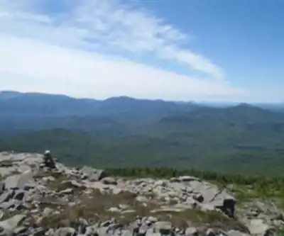
"replacement_paragraph": "The Traveler stands as Maine's eighth-most prominent peak and the state's highest volcanic mountain, rising to 3,541 feet from the wilderness of Baxter State Park in Piscataquis County. The mountain's distinctive complex ridge system and multiple summits create a substantial mountain massif rather than a single summit experience."
}
Recommended gear for this trail


Ready to go?
Everything you need to know before you goStarting Point
To access the hiking trails, you can start at the South Branch Pond Campground. The address is Baxter State Park, T6 R9 WELS, ME 04462. This location serves as a primary trailhead for the area.
When?
How much?
- Hiking shoes Essential
- → Salomon Elixir Tour Mid WP · 203.38 $
- Layered clothing Essential
- Rain jacket Essential
- Trekking poles
- → Black Diamond Trail Ergo Cork · 69.99 $
- Headlamp
- → Petzl Actik Core 625 · 103.95 $
FAQ - Frequently asked questions
Everything you need to knowThe Essential Hiking Checklist
Everything you need for your next hike. Bilingual, printable, 1 page.
Download the free checklistSimilar hikes nearby
Discover other trails you might enjoy

Chimney Peak, Maine
Maine Highlands

Katahdin
Maine Highlands
Little Spencer Mountain
Maine Highlands
barnard mountain
Maine Highlands
Pleasant Pond Mountain
Maine Highlands
Katahdin Lake
Maine Highlands
Hiking near Bangor
0 trails to explore ~141 km away
We work hard to provide the most up-to-date and error-free data possible. If something seems incorrect, let us know! Your contribution helps the whole community.
Hikers' opinions