

Ready to explore Cranberry Peak, Maine? Here's everything you need to know before you go!
Discover the trail

Trail description
Description
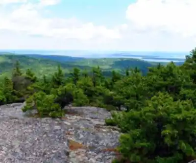
Cranberry Peak rises 3,213 feet above sea level in Maine's Bigelow Mountain Range, offering one of the most rewarding summit experiences in the western mountains. This prominent peak delivers expansive views of Flagstaff Lake and the surrounding wilderness, making it a standout destination for hikers seeking both challenge and scenic payoff.
The mountain sits within a rugged landscape that showcases Maine's diverse terrain. As you climb, you'll transition through dense hardwood and conifer forests before emerging onto exposed ridges where the real views begin. The summit provides a 360-degree panorama that takes in the rolling peaks of the Bigelow Range, the sprawling waters of Flagstaff Lake below, and miles of unbroken forest stretching to the horizon.
Trail Routes and Terrain
The primary route to Cranberry Peak follows the Appalachian Trail, beginning at the trailhead on Stratton Brook Pond Road. This approximately 5-mile round-trip hike takes you through varied terrain that keeps the ascent interesting throughout. The trail starts in lush forest where you'll navigate root-crossed paths and occasional muddy sections, particularly during spring snowmelt and after heavy rains.
As you gain elevation, the forest canopy opens up and the terrain becomes increasingly rocky. Granite slabs and boulder fields require careful foot placement, especially when wet. The final approach to the summit involves scrambling over exposed rock faces and navigating narrow ridgeline sections where the trail becomes more demanding.
For hikers wanting to extend their adventure, the Bigelow Range Trail connects Cranberry Peak to other summits in the range. This longer route adds significant mileage but rewards you with additional scenic overlooks and the chance to experience more of Maine's high country. The ridge walk between peaks offers some of the most spectacular hiking in the region, with open views and alpine-like conditions.
Wildlife and Natural Features
The diverse ecosystems along the Cranberry Peak trail support a variety of wildlife. White-tailed deer are commonly spotted in the lower elevations, while the higher reaches provide habitat for moose, black bears, and various bird species. Keep your eyes open for raptors soaring above the ridgelines and listen for the calls of loons echoing across Flagstaff Lake.
The flora changes dramatically with elevation. Lower sections feature typical Maine forest species including maple, birch, and beech trees that create stunning displays during fall foliage season. Higher up, spruce and fir dominate, and near the summit, you'll find hardy alpine plants adapted to the harsh conditions of exposed ridges.
Seasonal Considerations and Timing
Weather conditions on Cranberry Peak can change rapidly, particularly at higher elevations where temperatures drop and winds increase significantly. Even on warm valley days, the summit can be cold and windy, so layered clothing is essential regardless of season.
Starting your hike early in the day offers several advantages beyond avoiding crowds. Morning temperatures are cooler, making the ascent more comfortable, and early light often provides the clearest views from the summit. Afternoon thunderstorms are common during summer months, and you want to be off exposed ridges before they develop.
Winter hiking on Cranberry Peak requires advanced skills and equipment including snowshoes or microspikes, as the trail becomes significantly more challenging with snow and ice. The exposed sections near the summit can be particularly treacherous in winter conditions.
Essential Gear and Preparation
Sturdy hiking boots with good ankle support are crucial for the rocky terrain you'll encounter, especially in the upper sections of the trail. The uneven surfaces and potential for loose rock make proper footwear a safety necessity rather than just a comfort consideration.
Water requirements are higher than you might expect for a 5-mile hike due to the elevation gain and exposure. Pack more than you think you'll need, especially during hot weather when dehydration becomes a serious concern. Energy-rich snacks help maintain stamina during the steeper sections of the climb.
A camera is practically mandatory given the spectacular views, but consider bringing extra batteries as cold temperatures can drain them quickly. Weather protection including rain gear and warm layers should be standard equipment, as conditions can deteriorate rapidly in the mountains.
Trail Ethics and Environmental Responsibility
Cranberry Peak's pristine environment depends on hikers following Leave No Trace principles. Pack out all trash, stay on designated trails to prevent erosion, and avoid disturbing wildlife. The fragile alpine vegetation near the summit is particularly vulnerable to damage and takes years to recover from trampling.
Respect wildlife habitats by observing animals from a distance and storing food properly. Black bears are present in the area, and proper food storage protects both hikers and wildlife. Never feed wild animals, as this creates dangerous situations and disrupts their natural behavior patterns.
The popularity of Cranberry Peak means the trail sees heavy use during peak seasons. Hiking during weekdays or shoulder seasons helps reduce your impact and provides a more solitary experience. When encountering other hikers, practice trail courtesy by yielding appropriately and keeping noise levels down to preserve the natural quiet that many people seek in the wilderness.
Recommended gear for this trail


Ready to go?
Everything you need to know before you goStarting Point
To access the hiking trails, you can start at the trailhead located at the Bigelow Preserve. The primary parking area is at the Appalachian Trail crossing on Stratton Brook Pond Road. Another option is to begin from the trailhead at the end of Currie Street in Stratton, where there is also parking available.
When?
How much?
- Hiking shoes Essential
- → Salomon Elixir Tour Mid WP · 203.38 $
- Layered clothing Essential
- Rain jacket Essential
- Trekking poles
- → Black Diamond Trail Ergo Cork · 69.99 $
- Headlamp
- → Petzl Actik Core 625 · 103.95 $
FAQ - Frequently asked questions
Everything you need to knowThe Essential Hiking Checklist
Everything you need for your next hike. Bilingual, printable, 1 page.
Download the free checklistSimilar hikes nearby
Discover other trails you might enjoy

Long Mountain
Western Mountains
Pleasant Mountain
Western Mountains
Witt's End Trail
Western Mountains
Tumbledown Mountain
Western Mountains
Bear Mountain Inn + Barn Maine
Western Mountains
Bald Pate Mountain
Western Mountains
Hiking near Sherbrooke
53 trails to explore ~122 km away
We work hard to provide the most up-to-date and error-free data possible. If something seems incorrect, let us know! Your contribution helps the whole community.
Hikers' opinions