Hiking Lake Musconetcong - panoramic view  tree outdoor landscape nature mountain sky autumn plant cloud background lake painting forest surrounded distance
--°C
Loading...
See forecast →

Hiking in Lake Musconetcong: trails, map and practical info

Highlands Region • New Jersey

4.3 Appreciated by 19 hikers
François Dumaine
By François DumaineContributor since 2022Updated 23/06/2026
Difficulty
Easy
Distance
3 km
Elevation
14 ft
Duration
1h

Explore 3.2 km of lakeside trails through New Jersey's Highlands Region with minimal elevation gain—a 1-hour easy walk perfect for families. Serene woodlands and water views create an accessible escape near Netcong, ideal for birdwatching and seasonal foliage.

Recommended for :
Beginners

Ready to explore Lake Musconetcong? Here's everything you need to know before you go!

Discover the trail

Oh no! We don't have any photos 😢

This trail hasn't been captured yet. Be the first to share your adventure!

Trail description

Trail Network and Terrain

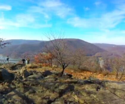
The 3.2-kilometer trail system around Lake Musconetcong follows well-maintained paths that meander through serene woodlands and along the water's edge. The terrain is relatively flat with minimal elevation changes, making the walking comfortable and accessible while still providing enough variety to keep things interesting. Most hikers complete the circuit in about an hour, though taking time for wildlife observation and photography can easily extend your visit.

The woodland paths offer an immersive forest experience where the gentle rustle of leaves and soothing sounds of water create a natural soundtrack. You'll walk on a combination of packed earth, occasional rocky sections, and some boardwalk areas near the water. Trail surfaces remain relatively stable throughout most of the year, though spring snowmelt and heavy rains can create muddy conditions in lower-lying sections.

Several trail segments bring you directly to the lake's edge, where you can pause to take in water views and watch for wildlife activity. These lakeside sections offer the best opportunities for photography and wildlife observation, particularly during early morning and late afternoon hours when animals are most active. The flat terrain makes these viewpoints easily accessible for hikers of all ages and abilities.

Recommended gear for this trail

LGPO Pick
Elixir Tour Mid WP
Salomon
Elixir Tour Mid WP
4.5 (2847 reviews)
Waterproof mid-height boot ideal for rocky terrain
203.38 $
See price
Daylite Plus 20L
Osprey
Daylite Plus 20L
4.7 (3215 reviews)
Lightweight and versatile for day hikes
109.99 $
See price
Most Popular
Wide Mouth 1L
Nalgene
Wide Mouth 1L
4.8 (12540 reviews)
Unbreakable and BPA-free — a hiking essential
23.11 $
See price
Best Value
Trail Ergo Cork
Black Diamond
Trail Ergo Cork
4.4 (1456 reviews)
Comfortable cork grip for long ascents
69.99 $
See price
Actik Core 625
Petzl
Actik Core 625
4.6 (1893 reviews)
USB rechargeable with 600 lumens for early starts
103.95 $
See price
Affiliate links — LGPO may earn a commission at no extra cost to you.

Ready to go?

Everything you need to know before you go

Where?

Address
Lake Musconetcong, New Jersey, USA
GPS coordinates
40.9068343, -74.6941988
Phone
Not available

Starting Point

The easiest way to get to the start of the trails at the lake musconetcong is to take Route 206 north to Netcong and take the first exit, which is for Route 183. Make a right onto Route 183 and follow it until you reach the lake. The trailhead is located on the east side of the lake.

When?

Opening hours
From sunrise to sunset
Varies by season
Best season
Fall
Spectacular colors
Best time
Early morning
Less crowded
Weather (next days)
Loading

How much?

Entry fees
Adult
Not available
Child
What to bring?
Gear
Download the PDF checklist
Water & food
2L minimum
No water point on the trail
Bring energy snacks for a 4h+ hike
Good to know
Park rules
No dogs
Safety
Download the GPX before you go
Limited cellular coverage on the trail
Slippery after rain
Be careful on rocky sections
In an emergency
Emergency
911
Parking GPS
40.9068343, -74.6941988
Center
Not available

Hikers' opinions

4.3
5 Reviews
M
Marcus
Nov 22, 2025
Lake Musconetcong delivers a serene walking experience perfect for those seeking a gentle outdoor adventure. The 3.2 km route with minimal elevation gain makes it ideal for families and casual hikers. The lakeside setting provides beautiful natural scenery throughout the walk, and the straightforward path keeps navigation simple for visitors of all experience levels.
R
Robert
Oct 18, 2025
This 3.2 km lakeside trail in the Highlands Region offers a peaceful escape with minimal elevation challenges. The route is well-suited for a quick outdoor break or a leisurely morning walk. The scenic water views and accessible terrain make it an excellent choice for those looking to enjoy nature without demanding physical exertion.
J
Jennifer
Aug 14, 2025
This lake trail offers a pleasant way to spend an afternoon in the Highlands Region. While the scenery is nice and the easy difficulty level is welcoming, parking arrangements require advance planning and payment. The 3.2 km distance is manageable for most visitors, though some may find the walk a bit short for a full day outing.
D
David
May 9, 2025
A wonderful spot for a relaxing lakeside stroll with minimal physical demands. The 10-meter elevation gain ensures accessibility for visitors of varying fitness levels. The natural beauty surrounding the water makes this 3.2 km route feel longer and more rewarding than the distance suggests, offering good value for a peaceful outdoor experience.
R1
Review 1
Jan 15, 2024
Lake Musconetcong offers a peaceful 2-3 hour outdoor experience in the beautiful Highlands Region. The minimal elevation gain of just 10 meters makes it accessible for most visitors. Getting there via Route 206 to Netcong and then Route 183 is straightforward, with the trailhead conveniently located on the lake's east side. A lovely spot for a relaxing day out.

FAQ - Frequently asked questions

Everything you need to know
Easy
13.70 m
1h
No
No
Yes, the Lake Musconetcong trail is rated as Easy, making it suitable for beginners and those looking for a leisurely walk. With only 10 m of elevation gain over 3.2 km, it requires minimal fitness level and is accessible to most visitors.
The Lake Musconetcong trail has an elevation gain of 10 m, making it a very flat and easy walk. This minimal elevation change makes it ideal for families and those seeking a relaxed hiking experience.
Didn't find your answer?
Free 1 pages

The Essential Hiking Checklist

Everything you need for your next hike. Bilingual, printable, 1 page.

Download the free checklist
Top 10 best hiking in Highlands Region
Our ranking based on hiker reviews

Hiking near Newark

0 trails to explore ~48 km away

View trails
Did you spot an error?

We work hard to provide the most up-to-date and error-free data possible. If something seems incorrect, let us know!

Update : June 2026