
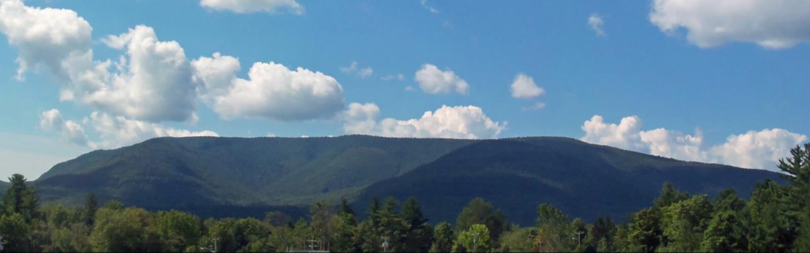

Ready to explore Plateau Mountain, New York? Here's everything you need to know before you go!
Discover the trail

Trail description
Plateau Mountain stands as one of the Catskill High Peaks at 3,840 feet, offering hikers a serious challenge through some of New York's most rugged terrain. Located in the heart of the Catskill Mountains, this peak attracts both seasoned adventurers tackling the Catskill 3500 Club list and determined hikers ready to test themselves against the notorious Devil's Path.
The Trail Experience
The primary route to Plateau Mountain follows the Devil's Path, starting from the Mink Hollow Road trailhead for a 6-mile round trip journey. This trail has earned its reputation as one of the most challenging in the Catskills, featuring steep, unrelenting ascents that will push your endurance from the start. The path winds through dense hardwood forests where towering maples and birches create a canopy overhead, while the understory reveals ferns and wildflowers during the growing season.
As you climb higher, the terrain becomes increasingly rocky, with exposed outcrops and boulders that require careful navigation. The trail's notorious steepness means you'll gain elevation quickly, but the constant upward grind demands proper pacing and frequent rest stops. The rocky sections can be particularly challenging when wet, requiring extra attention to foot placement and potentially making the ascent more technical than a typical hiking trail.
The forest ecosystem changes as you ascend, transitioning from mixed hardwoods to more coniferous species adapted to the higher elevation and harsher conditions. This shift signals your approach to the summit area, where the trees become shorter and the landscape more exposed.
Summit Views and Rewards
The primary viewpoint, Orchard Point, delivers the panoramic vistas that make the challenging climb worthwhile. On clear days, the sweeping views extend across the Hudson Valley, revealing the patchwork of farms, forests, and communities that define this region of New York. The elevated perspective allows you to appreciate the scale and beauty of the Catskill range, with neighboring peaks rolling away in all directions.
The summit area itself provides a stark contrast to the enclosed forest experience of most of the climb. Here, exposed rock and limited vegetation create an almost alpine feel, despite the relatively modest elevation. The sense of accomplishment at reaching this viewpoint is amplified by the knowledge that you've conquered one of the region's most demanding trails.
Wildlife and Natural Features
Throughout your hike, keep watch for the diverse wildlife that inhabits these forests. White-tailed deer are commonly spotted, particularly during early morning or late afternoon hikes. The varied bird life includes species adapted to different elevations, from woodland songbirds in the lower forests to raptors that soar above the ridgelines. The changing seasons bring different opportunities for wildlife observation, with spring migration and fall movements offering particularly active periods.
The trail passes through several distinct forest communities, each supporting different plant and animal species. The rocky outcrops and cliff areas provide habitat for specialized plants that have adapted to the harsh conditions of thin soil and exposure to weather.
Nearby Attractions and Extended Adventures
After completing your Plateau Mountain adventure, the Notch Lake picnic area offers an ideal spot to recover and refuel. Located within the scenic boundaries of Catskill Park, this facility provides tables and a peaceful setting surrounded by the natural beauty that defines this region. The contrast between the challenging mountain environment and the tranquil lake setting makes for a perfect end to your hiking day.
For those planning extended adventures in the area, Daley Ridge presents another challenging opportunity nearby. This peak also attracts Catskill 3500 Club members and offers its own unique terrain and viewpoints. The proximity of these challenging peaks makes the area attractive for multi-day adventures or return visits to tackle different routes.
Devils Tombstone, a historic site steeped in local folklore and mystery, adds cultural interest to your visit. This landmark provides insight into the human history of the region and the stories that have developed around these dramatic landscapes over generations.
Planning Your Visit
The 16.25-kilometer route with 1,170 meters of elevation gain typically requires 6 to 8 hours to complete, making this a full-day commitment. The "very hard" difficulty rating reflects both the steep terrain and the sustained nature of the climbing required. Proper preparation is essential for a safe and enjoyable experience.
Weather conditions can change rapidly at elevation, so check forecasts before departing and be prepared for conditions that may differ significantly from those at the trailhead. Carry a map or GPS device, as the trail can be challenging to follow in poor visibility or during leaf-off seasons when blazes may be more difficult to spot.
Essential gear includes sturdy hiking boots with good ankle support and aggressive tread for the rocky sections. Bring plenty of water—more than you think you'll need—and high-energy snacks to fuel your climb. The sustained effort required makes proper nutrition and hydration critical for both performance and safety.
The Leave No Trace principles are particularly important in this heavily used area of Catskill Park. Pack out everything you bring in, stay on designated trails to prevent erosion, and be considerate of other hikers who are also seeking to enjoy this challenging and rewarding mountain experience.
The Essential Hiking Checklist
Everything you need for your next hike. Bilingual, printable, 1 page.
Get your free hiking checklistRecommended gear for this trail
As an Amazon Associate I earn from qualifying purchases.


Ready to go?
Everything you need to know before you goStarting Point
To access the hiking trails, you can start at the Mink Hollow Road Trailhead. The trailhead is located at the end of Mink Hollow Road in Elka Park, NY. Another option is the Devil's Tombstone Campground area, which provides access to the trails from Route 214 in Hunter, NY. Both locations offer parking facilities for hikers.
When?
How much?
As an Amazon Associate I earn from qualifying purchases.
Affiliate links — LGPO may earn a commission at no extra cost to you.
- Hiking shoes Essential
- → Salomon Elixir Tour Mid WP · 203.38 $
- Layered clothing Essential
- Rain jacket Essential
- Trekking poles
- → Black Diamond Trail Ergo Cork · 69.99 $
- Headlamp
- → Petzl Actik Core 625 · 103.95 $
FAQ - Frequently asked questions
Everything you need to knowSimilar hikes nearby
Discover other trails you might enjoy

Old Mill Falls
Catskills
Catskill Scenic Trail
Catskills
Cliff Lake
Catskills
Plattekill Falls
Catskills
Ashokan Reservoir
Catskills
Devil's Path Trail
Catskills
Hiking near Poughkeepsie
0 trails to explore ~53 km away
We work hard to provide the most up-to-date and error-free data possible. If something seems incorrect, let us know! Your contribution helps the whole community.
Hikers' opinions
Be the first to review!
No hiker has shared their experience yet. Share your impressions and help other hikers!