Hiking Glastenbury Mountain, Vermont - panoramic view
--°C
Loading...
See forecast →

Hiking in Glastenbury Mountain, Vermont: trails, map and practical info

Southern Vermont • Vermont

4.0 Appreciated by 21 hikers
François Dumaine
By François DumaineContributor since 2015Updated 26/05/2026
Difficulty
Moderate
Distance
36 km
Elevation
1,142 m
Duration
11h30
Max altitude
1,047 m

Where the Long Trail and Appalachian Trail converge in Vermont's Green Mountains, this 36.4 km moderate trek climbs 1,142 m to Glastenbury Mountain's summit. Expect 6 to 8 hours on Bennington County's highest peak, steeped in mysterious local folklore.

Recommended for :
Intermediate hikers

Ready to explore Glastenbury Mountain, Vermont? Here's everything you need to know before you go!

Discover the trail

2 community photos

Trail description

Description

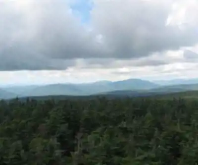
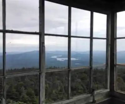
Glastenbury Mountain stands as the highest peak in Bennington County, Vermont, reaching 3,748 feet above sea level. Located within the Green Mountain National Forest, this prominent summit offers one of the most challenging and rewarding hiking experiences in southern Vermont's Green Mountains. The mountain serves as a crucial waypoint for long-distance hikers, as both the Long Trail and Appalachian Trail converge at its summit.

The 36.4-kilometer round-trip hike to Glastenbury Mountain presents a moderate challenge with 1,142 meters of elevation gain, typically requiring 6 to 8 hours to complete. This substantial distance makes it one of the longer day hikes in the region, demanding good physical conditioning and proper preparation. The trail follows the famous Long Trail, Vermont's 272-mile hiking corridor that runs the entire length of the state from Massachusetts to Canada.

Trail Experience and Terrain

The journey to Glastenbury Mountain's summit takes hikers through diverse Vermont forest ecosystems, beginning in mixed hardwood forests at lower elevations before transitioning into coniferous stands as you climb higher. The trail maintains the characteristic white blazes of the Long Trail, which coincides with the Appalachian Trail's white blazes along this section. This convergence means you'll likely encounter both section hikers tackling portions of these famous trails and through-hikers on multi-month journeys.

The ascent follows well-maintained but often rocky and root-filled trail sections typical of Vermont's Green Mountains. Expect stream crossings, particularly during spring snowmelt and after heavy rains, as the mountain's slopes feed into multiple watershed systems. The northeast slopes drain into Deer Lick Brook, eventually flowing to the Glastenbury River and continuing east to the Connecticut River and Long Island Sound. Meanwhile, water from the southwest slopes travels through Bolles Brook to the Roaring Branch of the Walloomsac River, ultimately reaching the Hudson River and New York Bay.

As you gain elevation, the forest canopy opens periodically to provide glimpses of the surrounding Green Mountain ridgelines. The final approach to the summit involves steeper terrain, but the trail remains well-marked and manageable for hikers with moderate experience.

Summit and Views

Glastenbury Mountain's summit offers expansive views across southern Vermont and into neighboring states. From this vantage point, hikers can observe the complex drainage patterns that make this peak a natural watershed divide. The northwest slopes feed the Fayville Branch of Warm Brook, which flows into Batten Kill and eventually the Hudson River system, while the southeast face contributes to Deer Cabin Brook and the Glastenbury River.

The summit area provides an excellent rest stop for the return journey and serves as a significant milestone for Appalachian Trail hikers traveling the 2,170-mile route from Georgia to Maine. The convergence of these two major trail systems adds historical and cultural significance to the hiking experience, connecting you to decades of Vermont hiking tradition and the broader long-distance hiking community.

Historical Context and Local Lore

Glastenbury Mountain carries a rich and somewhat mysterious history that adds intrigue to the hiking experience. The area has gained notoriety over the years due to several unexplained disappearances, contributing to local folklore and making it a topic of interest beyond the hiking community. While these stories shouldn't deter properly prepared hikers, they do add an element of mystique to the mountain's character and reflect the wild, remote nature of this corner of Vermont.

The mountain's location within the Green Mountain National Forest ensures protection of its natural resources while providing public access for recreation. This federal designation helps maintain the trail system and preserves the wilderness character that makes Glastenbury Mountain such a compelling destination for serious hikers.

Planning Your Hike

The substantial distance and elevation gain of this hike require careful planning and preparation. Start early in the day to ensure adequate daylight for the return journey, especially during shorter winter days. The 6 to 8-hour timeframe assumes a steady but comfortable pace with breaks for rest, food, and enjoying the summit views.

Weather conditions can change rapidly at elevation, particularly during Vermont's unpredictable shoulder seasons. The summit sits well above surrounding valleys, making it more exposed to wind and precipitation. Layer appropriately and carry rain gear regardless of the morning forecast.

Water sources exist along portions of the trail, but carrying sufficient water for the entire journey is recommended, especially during dry periods when streams may run low. The length of this hike means you'll need more food and water than typical day hikes in the region.

Navigation follows the well-marked Long Trail, but carrying a map and compass or GPS device provides additional security on this remote mountain. Cell phone coverage may be spotty or nonexistent in many areas, making self-reliance essential for safety.

The trail's moderate difficulty rating reflects both the substantial distance and the technical nature of some trail sections. While not requiring specialized mountaineering skills, this hike demands good physical fitness, proper footwear for rocky terrain, and experience with longer mountain hikes.

Ready to go?

Everything you need to know before you go

Where?

Address
Not available
GPS coordinates
42.977928, -73.071635
Phone
Not available

Starting Point

The trails at the glastenbury mountain, vermont in Vermont can be accessed from the trailhead on Route 9.

When?

Opening hours
From sunrise to sunset
Varies by season
Best season
Fall
Spectacular colors
Best time
Early morning
Less crowded
Weather (next days)
Loading

How much?

Entry fees
Adult
Not available
Child
What to bring?
Gear
  • Hiking shoes Essential
  • Layered clothing Essential
  • Rain jacket Essential
  • Trekking poles
  • Headlamp
Download the PDF checklist
Water & food
2L minimum
No water point on the trail
Bring energy snacks for a 4h+ hike
Good to know
Park rules
No dogs
Safety
Download the GPX before you go
Limited cellular coverage on the trail
Slippery after rain
Be careful on rocky sections
In an emergency
Emergency
911
Parking GPS
42.977928, -73.071635
Center
Not available

Hikers' opinions

4.0
14 Reviews
R7
Review 7
Apr 25, 2024
Amazing Vermont wilderness experience! Glastenbury Mountain's 36.4km trail showcases the state's natural beauty perfectly. The 1142m elevation gain provides steady climbing through diverse terrain. Though dogs aren't allowed and there are access fees, this moderate difficulty hike ranks among Vermont's finest outdoor adventures.
R6
Review 6
Apr 8, 2024
Pretty cool place. You will love for sure! :-) This Vermont mountain trail delivers amazing scenery across its 36.4km length. The moderate difficulty with 1142m elevation gain challenges hikers appropriately. Allow 6-8 hours for the complete experience, and access from Route 9 is straightforward despite the parking fees.
R5
Review 5
Mar 22, 2024
Very good place. I recommend this place. Glastenbury Mountain offers excellent hiking with its moderate difficulty level and substantial 1142m elevation gain. The 36.4km trail provides full-day adventure through Vermont's beautiful wilderness. Be prepared for paid parking and entrance fees, but the experience justifies the cost.
R4
Review 4
Mar 5, 2024
Mission accomplished. It's fab!! Conquered all 1142m of elevation gain on this challenging Vermont trail. The 36.4km distance tested my endurance, but the mountain views and diverse ecosystems made every step worthwhile. Started early from Route 9 trailhead and finished just within the 8-hour timeframe.
R3
Review 3
Feb 18, 2024
My favorite place. Despite the 36.4km distance and moderate difficulty, Glastenbury Mountain never disappoints. The Vermont landscape from the summit is breathtaking, and the well-maintained trails from Route 9 make navigation straightforward. This 6-8 hour adventure offers perfect solitude and natural beauty.

FAQ - Frequently asked questions

Everything you need to know
Moderate
1142.00 M
1047.00 M
11h30
No
No
The Glastenbury Mountain trail is 36.4 km long and typically takes 6 to 8 hours to complete. The duration can vary depending on your hiking pace, weather conditions, and rest stops along the way.
The Glastenbury Mountain trail has an elevation gain of 1142 m. This significant elevation change contributes to the moderate difficulty rating of the hike.
The Glastenbury Mountain hike is rated as moderate difficulty. With its 36.4 km distance and 1142 m elevation gain, it requires a good level of fitness and hiking experience.
No, dogs are not allowed on the Glastenbury Mountain trail. Plan accordingly if you typically hike with your pet, as you'll need to make alternative arrangements.
The Glastenbury Mountain trailhead can be accessed from Route 9 in Vermont. The trail is open from sunrise to sunset, so plan your start time accordingly for the 6 to 8 hour hike duration.
Didn't find your answer?
Free 1 pages

The Essential Hiking Checklist

Everything you need for your next hike. Bilingual, printable, 1 page.

Download the free checklist
Top 10 best hiking in Southern Vermont
Our ranking based on hiker reviews

Hiking near Saratoga Springs

0 trails to explore ~59 km away

View trails
Did you spot an error?

We work hard to provide the most up-to-date and error-free data possible. If something seems incorrect, let us know!

Update : June 2026