


Ready to explore Mount St. Helens? Here's everything you need to know before you go!
Discover the trail
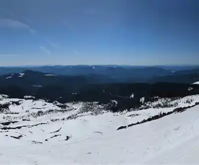
Trail description
Mount St. Helens is one of the most dramatic and geologically significant landscapes in the entire Pacific Northwest. Located in Washington State, this active stratovolcano is best known for its catastrophic eruption on May 18, 1980 — one of the most powerful volcanic events in recorded North American history. What was once a symmetrical, snow-capped peak was transformed in a matter of minutes into a landscape of raw, exposed earth, ash fields, and a massive open crater. Decades later, the mountain and its surroundings have become a living laboratory of ecological recovery, and one of the most compelling hiking destinations in the country.
A Volcano Like No Other
Hiking at Mount St. Helens isn't like hiking in a typical national forest or state park. The terrain here tells a story. You're walking through a landscape that was essentially reset — forests flattened, lakes buried, ridgelines reshaped. And yet, life has been pushing back steadily since 1980. Wildflowers colonize pumice fields. Elk herds roam the blast zone. Stands of young alder and fir are reclaiming slopes that were stripped bare. The contrast between the stark, grey volcanic terrain and the patches of returning green is something you genuinely have to see to understand.
The mountain sits within the Mount St. Helens National Volcanic Monument, managed by the USDA Forest Service. The monument was established in 1982 specifically to allow the landscape to recover naturally, with minimal human intervention. That mandate shapes the entire experience here — this isn't a manicured park, it's a place where nature is doing its own thing on its own timeline.
What to Expect on the Trails
Mount St. Helens offers a wide range of hiking experiences depending on which side of the mountain you approach from and what kind of terrain you're after. The most iconic objective is the summit climb, which takes hikers up the south flank through pumice plains, ash fields, and loose volcanic rock to the crater rim. It's a demanding route that requires a permit during the primary climbing season, and the conditions can shift quickly given the elevation and exposure.
Beyond the summit, there are trails that wind through the blast zone on the north side, giving hikers a ground-level view of the 1980 eruption's impact. Routes in this area pass through fields of downed, bleached logs — ghost forests that have barely changed since the eruption — alongside Spirit Lake, whose surface is still partially covered with floating logs displaced by the blast. It's an eerie and unforgettable scene.
On the south and east sides, the terrain shifts. You'll find lava tubes, lava canyons, and hardened lava flows that predate the 1980 eruption by centuries. Ape Cave, a lava tube that stretches for nearly two miles underground, is one of the most popular non-summit experiences at the monument. It's accessible year-round and requires a headlamp or lantern — no lighting is provided inside.
Permits and Access
Access to Mount St. Helens varies significantly depending on your objective. Climbing to the summit requires a permit, and the number of permits issued per day is limited. These permits are competitive and typically need to be reserved well in advance through the Forest Service's reservation system. There is a fee associated with the climbing permit.
For hiking below the summit — including trails in the blast zone, around Spirit Lake, and through the lava fields — a Monument Pass is generally required. Day-use fees apply at several trailheads and visitor facilities. Dogs are allowed on many trails within the monument but are restricted in certain areas, so it's worth checking current regulations before you go.
The monument has multiple entry points and visitor centers, including the Johnston Ridge Observatory on the north side, which sits directly across from the crater and offers some of the most dramatic views of the open volcanic vent. The observatory provides interpretive exhibits on the 1980 eruption and the ongoing geological activity of the mountain.
Seasons and Conditions
The monument is accessible in some form year-round, but the experience changes dramatically with the seasons. The summit climbing season typically runs from late spring through early fall, once the snowpack has receded enough to make the upper slopes manageable. Even in summer, the upper mountain can see snow, ice, and rapidly changing weather — proper gear is not optional.
Lower elevation trails and attractions like Ape Cave are accessible earlier in the season and later into the fall. Winter brings snowshoeing and cross-country skiing opportunities in certain areas, though road access to some parts of the monument may be limited or closed depending on conditions.
Spring is a particularly striking time to visit the blast zone, when wildflowers push through the volcanic soil and the contrast between new growth and the still-visible destruction is at its most vivid. Fall brings cooler temperatures and fewer crowds, which makes it a solid choice for hikers who want a quieter experience on the lower trails.
What Makes This Place Stand Out
There are plenty of volcanoes you can visit in the Cascades, but Mount St. Helens is the one that erupted within living memory. That recent history gives the landscape an immediacy that older volcanic terrain simply doesn't have. You're not looking at ancient geology — you're looking at a landscape that was fundamentally altered within the last half-century, and you can watch it change visit by visit if you come back over the years.
The scientific value of the monument is enormous, and that translates into a hiking experience that's genuinely educational without feeling like a classroom. Interpretive signs, ranger programs, and the sheer visibility of the geological processes at work make it easy to understand what you're looking at — and why it matters.
- Summit climbing permits are required and limited — book early through the Forest Service reservation system
- Monument Pass required for many trails and day-use areas
- Ape Cave requires a headlamp or lantern; no lighting provided underground
- Dogs are permitted in some areas but restricted in others — check current regulations
- Johnston Ridge Observatory offers direct views of the crater and eruption exhibits
- Weather on the upper mountain can change rapidly regardless of season — come prepared
Recommended gear for this trail
As an Amazon Associate I earn from qualifying purchases.


Ready to go?
Everything you need to know before you goWhen?
How much?
As an Amazon Associate I earn from qualifying purchases.
Affiliate links — LGPO may earn a commission at no extra cost to you.
- Hiking shoes Essential
- → Salomon Elixir Tour Mid WP · 203.38 $
- Layered clothing Essential
- Rain jacket Essential
- Trekking poles
- → Black Diamond Trail Ergo Cork · 69.99 $
- Headlamp
- → Petzl Actik Core 625 · 103.95 $
FAQ - Frequently asked questions
Everything you need to know
25 hikes under 2 hours from Montreal
Distance, elevation, parking and season for each one. The ones we go back to ourselves.
Get the guideSimilar hikes nearby
Discover other trails you might enjoy

Hiking near Victoria
93 trails to explore ~266 km away
We work hard to provide the most up-to-date and error-free data possible. If something seems incorrect, let us know! Your contribution helps the whole community.
Hikers' opinions
Be the first to review!
No hiker has shared their experience yet. Share your impressions and help other hikers!