


Ready to explore Mount St Helens? Here's everything you need to know before you go!
Discover the trail

Trail description
Mount St. Helens is one of the most dramatic and geologically significant landscapes in the entire Pacific Northwest. Located in Washington State, this active stratovolcano is best known for its catastrophic eruption on May 18, 1980 — one of the most powerful volcanic events in modern American history. What was once a symmetrical, snow-capped peak was transformed in a matter of hours into a landscape of raw, exposed earth, fallen forests, and a massive open crater. Decades later, the recovery of this landscape continues to unfold, and hiking here means walking through a living laboratory of ecological succession unlike anything else in the region.
A Volcano That Changed Everything
Before the 1980 eruption, Mount St. Helens was a popular destination for hikers and climbers. The blast — triggered by a massive landslide and lateral explosion — removed the upper portion of the mountain and flattened forests across a wide area. The eruption killed 57 people and caused widespread destruction. Today, the volcano sits within the Mount St. Helens National Volcanic Monument, managed by the USDA Forest Service, and it draws visitors from around the world who come to witness both the destruction and the remarkable resilience of nature.
What makes hiking here so compelling is the contrast. You move between zones of total devastation and areas of surprising regrowth — wildflowers pushing through volcanic ash, young alder and fir trees reclaiming the blast zone, and wildlife returning to a landscape that was essentially reset. It's humbling in a way that few hiking destinations can match.
The Terrain
The terrain around Mount St. Helens is unlike typical mountain hiking. Much of the monument features open, exposed ridgelines with sweeping views of the crater and lava dome. The ground underfoot shifts between hardened lava flows, loose pumice, and ash-covered slopes. Some trails wind through ghost forests — standing dead trees bleached silver by decades of exposure — while others cross the edges of the massive debris avalanche deposit that reshaped the entire north fork of the Toutle River valley.
The Johnston Ridge Observatory area offers some of the most direct views into the crater and is a natural starting point for many visitors. From there, the scale of the 1980 eruption becomes immediately apparent — the horseshoe-shaped crater, the lava dome slowly rebuilding inside it, and the miles of flattened terrain stretching out below.
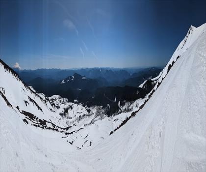
On the south side of the volcano, the character of the landscape shifts. Here, the eruption's effects were less severe, and the terrain feels more like a classic Cascade mountain environment — subalpine meadows, old-growth forest patches, and views of the surrounding peaks including Mount Rainier and Mount Adams on clear days.
What to Expect on the Trail
Trails at Mount St. Helens range from short interpretive walks to strenuous summit climbs. The summit route is a serious undertaking that requires a permit, solid fitness, and experience with steep, loose volcanic terrain. It is not a technical climb in the mountaineering sense, but the upper slopes involve significant elevation gain over unstable ground and should not be underestimated.
For hikers looking for a strong day out without the summit commitment, trails like the Boundary Trail and the Loowit Trail — which circumnavigates the entire volcano — offer extended, immersive experiences through the monument's most striking terrain. The Loowit Trail in particular is known for being rugged and poorly marked in sections, with multiple stream crossings that can be challenging depending on the season.
Shorter options exist as well, particularly near the visitor facilities on the south and west sides of the monument. These are well-suited for families or anyone wanting an introduction to the volcanic landscape without committing to a full day.
Permits and Access
Access to Mount St. Helens requires planning ahead. A Monument Pass is required to enter most areas of the national volcanic monument, and summit climbers need a separate climbing permit, which must be reserved in advance through the Forest Service. Permit quotas apply, especially during the busy summer season, so booking early is strongly recommended.
There are multiple entry points and trailheads depending on which side of the volcano you're approaching from. The Johnston Ridge Observatory on the north side and the Ape Cave and Windy Ridge areas are among the most visited. Road conditions and facility hours vary by season — many roads and trailheads are only fully accessible from late spring through early fall due to snow.
Wildlife and Ecology
The ecological recovery of Mount St. Helens has been closely studied by scientists for decades, and the results are visible on the ground. Elk herds have returned in significant numbers to the blast zone. Pocket gophers, which survived underground during the eruption, played a key role in reintroducing soil nutrients and seeds. Prairie lupine was among the first plants to colonize the bare pumice plains, and its nitrogen-fixing roots helped kick-start the broader recovery of plant communities.
Spirit Lake, which was dramatically altered by the eruption — its surface rising significantly due to the debris avalanche — has also seen the return of aquatic life. The log mat that still covers portions of the lake's surface is a lasting visual reminder of the forests that were swept into it during the blast.
Practical Tips
- Book permits early: Summit climbing permits sell out quickly, especially for weekends in July and August.
- Check road conditions: Some access roads, particularly to Windy Ridge, may have limited seasonal hours or closures.
- Bring sun protection: The blast zone offers very little shade. The open terrain means full sun exposure for much of the day.
- Carry plenty of water: Water sources in the blast zone are limited and may be silty or unreliable.
- Wear sturdy footwear: Loose pumice and volcanic rock make ankle support important on most trails.
- Visit the Johnston Ridge Observatory: The exhibits provide essential context for understanding what you're seeing on the landscape.
Mount St. Helens is a place that rewards curiosity. Whether you're here for the geology, the ecology, the history, or simply the raw visual power of an active volcano, the landscape delivers something that stays with you long after you've driven back down the mountain.
Recommended gear for this trail
As an Amazon Associate I earn from qualifying purchases.


Ready to go?
Everything you need to know before you goWhen?
How much?
As an Amazon Associate I earn from qualifying purchases.
Affiliate links — LGPO may earn a commission at no extra cost to you.
- Hiking shoes Essential
- → Salomon Elixir Tour Mid WP · 203.38 $
- Layered clothing Essential
- Rain jacket Essential
- Trekking poles
- → Black Diamond Trail Ergo Cork · 69.99 $
- Headlamp
- → Petzl Actik Core 625 · 103.95 $
FAQ - Frequently asked questions
Everything you need to know
25 hikes under 2 hours from Montreal
Distance, elevation, parking and season for each one. The ones we go back to ourselves.
Get the guideSimilar hikes nearby
Discover other trails you might enjoy

Hiking near Victoria
93 trails to explore ~266 km away
We work hard to provide the most up-to-date and error-free data possible. If something seems incorrect, let us know! Your contribution helps the whole community.
Hikers' opinions
Be the first to review!
No hiker has shared their experience yet. Share your impressions and help other hikers!