

Ready to explore Crescent Falls? Here's everything you need to know before you go!
Discover the trail
Trail description
Description
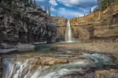
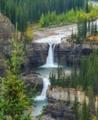
Crescent Falls stands out as one of the most accessible and rewarding waterfall destinations in David Thompson Country. The cascades tumble down a series of rocky ledges along the Bighorn River, creating a picturesque sight that you can hear long before you see it. What makes this spot special isn't just the falls themselves, but how the rushing water has carved intricate patterns into the limestone bedrock over thousands of years, forming the crescent-shaped pools that give the falls their name.
The surrounding landscape perfectly captures the essence of the Canadian Rockies without requiring the commitment of a full-day mountain expedition. Dense spruce and fir forests frame the falls, while rugged cliffs rise on either side of the river valley. On clear days, you'll catch glimpses of snow-capped peaks through the treeline, but the real show happens right in front of you as the mountain water flows down the rock face.
The Trail Experience
The main trail to Crescent Falls follows a well-maintained path that's suitable for hikers of all experience levels. Despite the 71-meter elevation change over 4.9 km, the route is classified as easy, making it an excellent choice for families or anyone looking for a rewarding outdoor experience without technical challenges. Most visitors complete the journey in about an hour and fifteen minutes, though you'll want to budget extra time to fully appreciate the multiple viewpoints and photo opportunities.
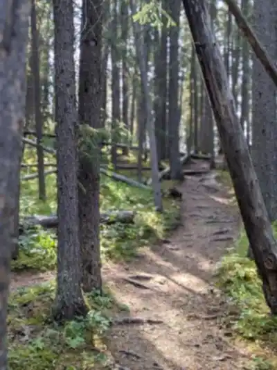
You'll start in mixed forest, walking on packed earth and occasional wooden boardwalks that help protect the more sensitive areas along the route. The trail winds gradually through the terrain, managing the elevation gain in comfortable stages rather than steep climbs. As you approach the falls, the sound of rushing water grows louder and the air becomes noticeably cooler and more humid.
The trail provides access to several distinct viewpoints, each offering a different perspective on the cascading water. The lower viewpoint puts you almost at water level, where you can feel the mist on your face and watch the water swirl through the carved rock channels. Higher up, you'll find spots that showcase the full height of the falls and the way they've shaped the surrounding landscape. The variety of vantage points means you can spend considerable time exploring different angles and finding the perfect spot for photos or simply taking in the natural spectacle.
For those wanting to extend their adventure, additional trails branch off from the main route and wind deeper into the surrounding wilderness. These paths offer opportunities to spot local wildlife including deer, various bird species, and occasionally black bears during berry season. The extended trails also provide panoramic views of the broader David Thompson Country region, with its mix of forested valleys and distant mountain ranges.
Seasonal Variations and Timing
Crescent Falls transforms dramatically with the seasons, and each time of year offers distinct advantages for visitors. The falls remain accessible year-round, though your experience will vary significantly depending on when you arrive.
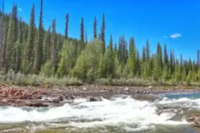
Summer brings the most dramatic water flow, as snowmelt from higher elevations feeds the Bighorn River. The trails are at their most accessible during these months, and wildflowers bloom along the forest floor and in the meadow areas near the trailhead. The lush green forest provides excellent shade on hot days, and the mist from the falls offers natural air conditioning that makes the area particularly refreshing during warm weather.
Autumn transforms the area into a showcase of color as the deciduous trees and shrubs turn brilliant shades of yellow, orange, and red. The water flow typically decreases somewhat from summer levels, but this actually makes it easier to see the intricate rock formations and carved channels that the water has created over time. The cooler temperatures make hiking more comfortable, and the reduced crowds mean you're more likely to have the viewpoints to yourself for extended periods.
Winter creates an entirely different landscape as the falls partially freeze, forming dramatic ice formations alongside the still-flowing water. The contrast between the white ice, dark rock, and moving water creates striking photographic opportunities. Snow-dusted trees complete the winter wonderland effect, though you'll need appropriate footwear and clothing for winter conditions, including ice grippers for the potentially slippery sections near the falls.
Wildlife and Natural Features
The diverse ecosystem around Crescent Falls supports a variety of wildlife that you might encounter during your visit. The mixed forest habitat attracts numerous bird species, from small songbirds to larger raptors that hunt along the river corridor. White-tailed and mule deer are commonly spotted, especially during early morning or evening visits when they come to drink from the river.
The geological features around the falls tell the story of how water and time have shaped this landscape. The limestone bedrock shows clear evidence of the erosional processes that created the falls, and you can observe different rock layers that represent millions of years of geological history. The crescent-shaped pools that give the falls their name are particularly visible during lower water periods and demonstrate the power of moving water to carve even hard rock into smooth, curved forms.
The spray zone around the falls creates a unique microclimate that supports different plant species than you'll find in the drier forest areas. Mosses and ferns thrive in the constant moisture, creating lush green patches that contrast beautifully with the surrounding rock faces. This moisture also supports a variety of insects and small creatures that form the base of the local food web.
Practical Planning and Safety
When preparing for your visit to Crescent Falls, sturdy hiking boots are essential even though the trail is rated as easy. The path can be muddy in places, especially during spring snowmelt or after rain, and the rocks near the falls can be slippery from the constant mist. The elevation gain, while manageable, does require a basic level of fitness, and the rocky terrain near the viewpoints demands attention to footing.
Weather-appropriate clothing is crucial since conditions can change quickly in the mountains, and the temperature near the falls is typically several degrees cooler than in the surrounding forest. Layered clothing works best, allowing you to adjust as you move between the warmer forest sections and the cooler areas near the water.
Bring plenty of water, especially during summer visits when the combination of hiking and the dry mountain air can lead to dehydration more quickly than you might expect. The picnic areas near the falls provide excellent spots to rest and enjoy a meal while listening to the sound of rushing water. These areas include basic facilities but no garbage collection, so plan to pack out everything you bring in.
The trail and falls area are designed to handle visitors while protecting the natural environment. Staying on designated trails helps prevent erosion and protects sensitive vegetation, while also ensuring your safety around the steep areas near the falls. The viewing areas are positioned to provide excellent photo opportunities while keeping visitors at a safe distance from the most dangerous sections near the water.
Recommended gear for this trail


Ready to go?
Everything you need to know before you goStarting Point
The crescent falls are located in the Kananaskis Country of Alberta. To get to the start of the trails, take the Trans-Canada Highway (Highway 1) to the exit for Kananaskis Country. Follow the signs for the Peter Lougheed Provincial Park. The park is about an hour's drive from Calgary. Once you are in the park, follow the signs for the crescent falls.
When?
How much?
- Hiking shoes Essential
- → Salomon Elixir Tour Mid WP · 203.38 $
- Layered clothing Essential
- Rain jacket Essential
- Trekking poles
- → Black Diamond Trail Ergo Cork · 69.99 $
- Headlamp
- → Petzl Actik Core 625 · 103.95 $
FAQ - Frequently asked questions
Everything you need to knowThe Essential Hiking Checklist
Everything you need for your next hike. Bilingual, printable, 1 page.
Download the free checklistSimilar hikes nearby
Discover other trails you might enjoy

Hiking near Jasper
82 trails to explore ~129 km away
We work hard to provide the most up-to-date and error-free data possible. If something seems incorrect, let us know! Your contribution helps the whole community.
Hikers' opinions