Hiking Rocky Mountain House - panoramic view  tree outdoor landscape nature mountain sky autumn plant cloud background lake painting forest surrounded distance
--°C
Loading...
See forecast →

Hiking in Rocky Mountain House: trails, map and practical info

David Thompson Country • Alberta

3.0 Appreciated by 38 hikers
François Dumaine
By François DumaineContributor since 2022Updated 26/05/2026
Difficulty
Moderate
Distance
2
Elevation
325 ft
Duration
1h30
Max altitude
2,012 ft

Explore 1.6 km through David Thompson Country in Alberta's foothills, where dense boreal forests lead to dramatic limestone cliffs and alpine terrain. This moderate hike gains 325 m elevation in roughly 1.5 hours, rewarding steady climbers with panoramic views across the North Saskatchewan River valley.

Recommended for :
Intermediate hikers

Ready to explore Rocky Mountain House? Here's everything you need to know before you go!

Discover the trail

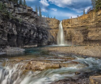
Oh no! We don't have any photos 😢

This trail hasn't been captured yet. Be the first to share your adventure!

Trail description

Description

Rocky Mountain House sits at the edge of Alberta's foothills, where the prairies give way to the towering peaks of the Canadian Rockies. This small town has earned its reputation as a launching pad for some of central Alberta's most rewarding hiking experiences, offering everything from gentle lakeside walks to demanding mountain ascents that test even experienced hikers.

The landscape here tells the story of Alberta's geological diversity. Dense boreal forests carpet the rolling hills, broken by crystal-clear lakes that reflect the sky and surrounding peaks. Rivers carve through valleys lined with aspen and spruce, while higher elevations reveal the dramatic limestone cliffs and alpine meadows that make this region so distinctive. Wildlife thrives in these varied ecosystems—black bears, elk, and moose call these forests home, while smaller creatures like pika and marmots inhabit the rockier terrain.

Trail Networks and Hiking Options

Crimson Lake Provincial Park provides the most accessible hiking from Rocky Mountain House, located just a short drive from town. The park's trail system winds through mature forests of white spruce and aspen, connecting several pristine lakes that remain refreshingly cool even during summer's peak. The Amerada Trail stands out as the park's signature route, following the shoreline where the forest opens up to reveal expansive water views. Early morning hikers often spot deer coming to drink, while the patient observer might catch glimpses of beaver activity in the quieter bays. The well-maintained paths make this an excellent choice for families or those seeking a more relaxed outdoor experience without sacrificing natural beauty.

For hikers ready to tackle more challenging terrain, the Nordegg area delivers the kind of mountain experiences that define Alberta hiking. Coliseum Mountain presents a serious ascent through changing ecosystems, beginning in dense forest before emerging onto exposed ridges where the views stretch across wave after wave of peaks. The trail demands steady climbing and sure footing, particularly in the upper sections where loose rock requires careful navigation. Baldy Fire Lookout offers a different but equally rewarding challenge, following an old access road that switchbacks up the mountainside to a historic fire tower. The panoramic views from the summit encompass the entire David Thompson Country, with the North Saskatchewan River valley spreading out far below.

David Thompson Country represents some of Alberta's most spectacular backcountry hiking. Named for the legendary explorer and mapmaker, this region preserves the wild character that Thompson himself would recognize. The Siffleur Falls Trail exemplifies what makes this area special—a moderate hike that leads through old-growth forest to a series of cascading waterfalls that thunder into a narrow canyon. The trail follows Siffleur Creek upstream, crossing wooden bridges and navigating rocky sections where the water has carved dramatic channels through the limestone bedrock. The falls themselves drop in multiple tiers, creating pools and eddies that invite longer stops for photography or simply absorbing the power of moving water.

Terrain and Trail Experience

The hiking around Rocky Mountain House showcases the dramatic transition zone between Alberta's central plains and the Rocky Mountain foothills. Lower elevation trails meander through mixed boreal forest where the understory bursts with wildflowers during peak summer months. These gentler routes follow natural contours, crossing wooden boardwalks over marshy sections and offering frequent rest spots beside beaver ponds and quiet streams.

As elevation increases, the character shifts dramatically. Trails become steeper and more technical, winding through stands of lodgepole pine and eventually breaking into alpine zones where hardy shrubs and grasses cling to rocky slopes. The limestone geology creates unique features—natural arches, deep crevices, and fossil-rich rock faces that tell the story of ancient seas. Weather can change rapidly at higher elevations, with afternoon thunderstorms rolling in quickly during summer months.

Wildlife and Natural Features

The diverse ecosystems around Rocky Mountain House support an impressive array of wildlife. Mountain goats navigate the steepest cliffs, while bighorn sheep prefer the grassy slopes and rocky outcrops. The extensive forest cover provides habitat for both black bears and the occasional grizzly, making proper food storage and bear awareness essential for all hikers. Lynx and wolves move through these forests, though sightings remain rare due to their elusive nature.

Bird life thrives in the varied habitats, from waterfowl on the numerous lakes to raptors soaring above the ridgelines. Gray jays, known locally as whiskey jacks, often become bold companions at higher elevations, while the haunting call of loons echoes across the larger lakes during evening hours. The region's rivers and streams support healthy populations of native fish species, contributing to the complex web of life that makes this ecosystem so resilient.

Seasonal Considerations and Activities

Summer hiking season typically runs from late May through early October, though higher elevation trails may retain snow well into June. July and August offer the most reliable weather, with warm days perfect for longer hikes and comfortable camping. However, these months also bring the heaviest trail traffic, particularly on weekends. Early fall provides some of the year's best hiking conditions, with cooler temperatures, fewer crowds, and the spectacular color show of changing aspen leaves.

Winter transforms the landscape into a different kind of outdoor playground. Cross-country skiing becomes the primary way to explore the trail networks, with many summer hiking routes doubling as ski trails once snow covers the ground. Snowshoeing opens up even more possibilities, allowing winter adventurers to break trail through untracked forest and experience the profound quiet of the snow-covered wilderness. The North Saskatchewan River, partially frozen but still flowing, creates dramatic ice formations that make winter photography particularly rewarding.

Beyond the Trails

The region's numerous lakes and rivers provide excellent fishing opportunities, with northern pike, walleye, and various trout species inhabiting different waters. The North Saskatchewan River offers particularly good canoeing, with sections suitable for beginners as well as more challenging runs for experienced paddlers. The river's broad valley provides a different perspective on the landscape, revealing geological formations and wildlife viewing opportunities not visible from the hiking trails.

Rocky Mountain House itself maintains the practical, unpretentious character typical of Alberta's smaller communities. Local restaurants serve substantial meals that satisfy post-hike appetites, often featuring locally sourced ingredients including game meats and regional specialties. The town's cafes provide gathering spots where hikers can compare notes on trail conditions and share recommendations for hidden gems in the surrounding backcountry. Equipment needs vary significantly depending on chosen activities and seasons, but the town's outdoor retailers can help ensure proper preparation for whatever adventure calls.

Ready to go?

Everything you need to know before you go

Where?

Address
Rocky Mountain House, AB, Canada
GPS coordinates
52.3776098, -114.9138509
Phone
Not available

Starting Point

To access the hiking trails, you can start from several trailheads in the area. Here are some options:

  1. Nordegg Trailhead: Located near Nordegg, Alberta, this trailhead provides access to various trails in the region. You can reach it by taking Highway 11 west from rocky mountain house for approximately 90 kilometers.

  2. David Thompson Resort Parking Lot: Situated along Highway 11, this parking lot offers another starting point for exploring nearby trails. It is about 45 kilometers west of Nordegg.

  3. Cline River Trailhead: This trailhead is accessible via Highway 11 and is located near the Cline River bridge, approximately 60 kilometers west of Nordegg.

  4. Siffleur Falls Staging Area: Found along Highway 11, this staging area provides access to the Siffleur Falls trail and other routes. It is roughly 65 kilometers west of Nordegg.

Ensure you check local maps and trail conditions before heading out, as distances and accessibility may vary depending on weather and road conditions.

When?

Opening hours
From sunrise to sunset
Varies by season
Best season
Fall
Spectacular colors
Best time
Early morning
Less crowded
Weather (next days)
Loading

How much?

Entry fees
Adult
Not available
Child
What to bring?
Gear
  • Hiking shoes Essential
  • Layered clothing Essential
  • Rain jacket Essential
  • Trekking poles
  • Headlamp
Download the PDF checklist
Water & food
2L minimum
No water point on the trail
Bring energy snacks for a 4h+ hike
Good to know
Park rules
No dogs
Safety
Download the GPX before you go
Limited cellular coverage on the trail
Slippery after rain
Be careful on rocky sections
In an emergency
Emergency
911
Parking GPS
52.3776098, -114.9138509
Center
Not available

Hikers' opinions

3.0
18 Reviews
S
Sarah
Oct 22, 2025
Fantastic autumn hike with beautiful fall colors lighting up the forest canopy. The steep grade makes every step count, and I definitely felt the burn in my legs by the top. Despite being short, this trail packs a real punch and offers excellent training value. The consistent uphill grade and well-established path make it perfect for building endurance for longer mountain adventures.
M
Marcus
Oct 15, 2025
This steep climb delivers impressive results for its short distance. The well-maintained trail with clear markings makes navigation straightforward, and the consistent uphill grade provides an excellent cardiovascular workout. I regularly use this route to build endurance for longer mountain expeditions. The steady terrain throughout keeps your heart rate elevated, making it ideal for interval training sessions.
S
Sarah
Sep 22, 2025
Beautiful fall foliage made this compact hike particularly enjoyable. Despite the short distance, the elevation gain packs a real punch and left my legs feeling the effort. Trail conditions were excellent with good signage throughout. The manageable length makes it perfect for an after-work adventure when daylight is limited, though budget for parking and access fees beforehand.
M
Marcus
Sep 15, 2025
This trail delivers a solid workout in a compact package. The 325m elevation gain over just 1.6km creates a challenging ascent that really gets your heart pumping. Trail maintenance is excellent with clear signage throughout. The fees for parking and access are a bit steep for such a short hike, but the trail quality justifies the cost. Perfect when you want a quick cardio session without committing to a full day adventure.
J
Jennifer
Jul 8, 2025
Excellent training hike that I use regularly for fitness preparation. The steady grade and manageable distance make it ideal for interval training and building stamina. Early morning starts help avoid crowds and provide the best experience. The forest provides good shade on hot summer days, and I've spotted various wildlife including ground squirrels and different bird species during my visits.

FAQ - Frequently asked questions

Everything you need to know
Moderate
325.00
2012.00
1h30
No
No
Yes, the Rocky Mountain House trail is rated as Easy difficulty, making it very suitable for beginners and those new to hiking. The 1.6 km distance and 1-hour duration also make it manageable for most fitness levels.
The Rocky Mountain House trail typically takes about 1 hour to complete and covers a distance of 1.6 km. The actual time may vary depending on your pace and how often you stop to enjoy the scenery.
The Rocky Mountain House trail has an elevation gain of 325 meters. Despite this moderate elevation change, the trail maintains an Easy difficulty rating.
No, dogs are not permitted on the Rocky Mountain House trail. Please plan accordingly and make alternative arrangements for your pets when visiting this trail.
The Rocky Mountain House trail is accessible from sunrise to sunset. Plan your hike accordingly to ensure you complete the trail before dark, especially during shorter winter days.
Didn't find your answer?
Free 1 pages

The Essential Hiking Checklist

Everything you need for your next hike. Bilingual, printable, 1 page.

Download the free checklist
Top 10 best hiking in David Thompson Country
Our ranking based on hiker reviews

Hiking near Airdrie

90 trails to explore ~136 km away

View trails
Did you spot an error?

We work hard to provide the most up-to-date and error-free data possible. If something seems incorrect, let us know!

Update : June 2026