

Ready to explore Saskatoon Island Provincial Park? Here's everything you need to know before you go!
Discover the trail
Oh no! We don't have any photos 😢
This trail hasn't been captured yet. Be the first to share your adventure!Trail description
Description
Saskatoon Island Provincial Park sits about 20 kilometers west of Grande Prairie, making it one of the more accessible serious hiking destinations in Alberta's Peace Country. Don't let that proximity to the city fool you — the 22-kilometer trail system with 1,310 meters of elevation gain is a genuine full-day commitment that earns its hard rating.
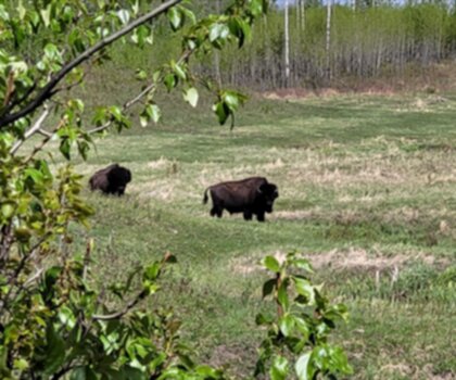
The park is probably best known regionally as a trumpeter swan sanctuary, and that reputation is well deserved. The mix of open lake, wetland, and boreal forest creates layered habitat that supports over 150 bird species. Whether you're a dedicated birder or just someone who appreciates seeing wildlife on a hike, the chances of meaningful encounters here are consistently high throughout the day.
What the Trail Actually Feels Like
Nine hours is the realistic estimate for this route, and that assumes you're moving at a steady pace without lingering too long at viewpoints or wildlife stops. The elevation gain — 1,310 meters over 22 kilometers — isn't concentrated in one brutal climb. Instead, it accumulates through a series of sustained ascents and descents that keep your legs working throughout the day. That pattern is actually harder to manage mentally than a single big push, so pacing yourself early matters.
The terrain shifts noticeably as you move through the park. Forest sections tend to be rooted and occasionally rocky underfoot, requiring attention to foot placement rather than just grinding out kilometers. When the trail opens up along Lake Saskatoon's shoreline, the walking eases but the ground can be soft and muddy depending on recent weather and the season. Those lakeside stretches are where you'll want to slow down anyway — the views across the water and the wildlife activity make them natural stopping points.
Higher sections of the trail reward the effort with panoramic views that extend well beyond the park's boundaries, giving you a real sense of the Peace Country landscape. These vantage points are worth the climb and make good targets for short breaks before continuing.
Wildlife and Ecosystem
Beaver activity has genuinely shaped the park's landscape in visible ways. You'll pass gnawed stumps, active dams, and the wetland areas that beaver engineering has created over time. These modified areas aren't just interesting to look at — they're directly responsible for much of the habitat diversity that makes the park such a productive spot for birds and other wildlife.
Deer are commonly seen moving through forest clearings, particularly in the early morning hours when wildlife activity is highest across the park. The intersection of boreal forest, wetland, and open water creates the kind of edge habitat that concentrates animal movement, so keeping your eyes up and your pace quiet pays off.
The trumpeter swans are the signature wildlife experience here. Lake Saskatoon provides critical habitat for these birds, and the park functions as an important sanctuary for the species in the region. Spotting them on the water during a lakeside section of the trail is one of those moments that sticks with you.
Seasonal Notes
Winter changes the character of the park significantly. The trail system transitions into cross-country skiing and snowshoeing territory, and snow cover makes animal tracking far easier than during other seasons. That said, the same route that takes 9 hours in summer will take considerably longer in winter conditions, and the more remote sections of the trail demand extra preparation and safety awareness.
Shoulder seasons bring their own considerations. Spring snowmelt and fall rain can make the lakeside sections particularly muddy, and stream crossings may be higher than expected. Checking conditions before heading out is worth the effort for a route this long.
Planning and Logistics
An early start is important for a 9-hour trail. Even in summer, you want enough daylight buffer to handle unexpected delays without rushing the back half of the route. Weather in Peace Country can shift quickly, and a route this long exposes you to changing conditions for an extended period — layering and rain gear belong in your pack regardless of the morning forecast.
Water management deserves real attention here. The lakeside sections offer resupply opportunities, but you'll need filtration equipment to use them safely. Carrying enough water for the full day adds meaningful pack weight, so planning your resupply points in advance helps balance the load.
Parking is available at the park and can fill on busy summer weekends when hikers share the lot with other park users. Arriving early solves that problem and gets you on trail during the best wildlife hours anyway.
Other Activities in the Park
The main trail is firmly in advanced territory, but Saskatoon Island Provincial Park accommodates a wider range of visitors. Lakeside picnic areas offer scenic spots for those not tackling the full route, and fishing on Lake Saskatoon is a popular alternative. Campground facilities support multi-day stays, which opens up the possibility of exploring the park across different conditions and times of day rather than trying to fit everything into a single visit.
For groups with mixed experience levels, the park works well as a base — serious hikers can take on the main trail while others enjoy the lake and shorter accessible areas near the park facilities.
Recommended gear for this trail


Ready to go?
Everything you need to know before you goStarting Point
The saskatoon island provincial park is located in Alberta. To get to the start of the trails, take Highway 2 to Boyle and then take Highway 63 north for about 15 km. The park is located on the east side of the highway.
When?
How much?
- Hiking shoes Essential
- → Salomon Elixir Tour Mid WP · 203.38 $
- Layered clothing Essential
- Rain jacket Essential
- Trekking poles
- → Black Diamond Trail Ergo Cork · 69.99 $
- Headlamp
- → Petzl Actik Core 625 · 103.95 $
FAQ - Frequently asked questions
Everything you need to knowThe Essential Hiking Checklist
Everything you need for your next hike. Bilingual, printable, 1 page.
Download the free checklistSimilar hikes nearby
Discover other trails you might enjoy

Kakwa Falls
Peace Country
Wood Bison Trail
Peace Country
Folding Mountain Trail Start
Peace Country
Misery Mountain Ski Area
Peace Country
Winagami Lake
Peace Country
Muskoseepi Park
Peace Country
Hiking near Jasper
82 trails to explore ~267 km away
We work hard to provide the most up-to-date and error-free data possible. If something seems incorrect, let us know! Your contribution helps the whole community.
Hikers' opinions