

Ready to explore Bruce Peninsula National Park? Here's everything you need to know before you go!
Discover the trail
Trail description
Description
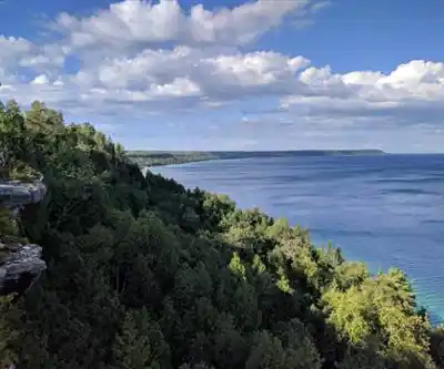
Bruce Peninsula National Park sits at the northern tip of the Bruce Peninsula in Ontario, where the land narrows between Georgian Bay and Lake Huron before giving way to open water. The park's high point — at 271 metres elevation — anchors a landscape defined by ancient limestone escarpment, old-growth forest, and some of the most dramatic coastal scenery in the province. This is the kind of place that earns its reputation honestly: the geology is genuinely striking, the trails are varied, and the views over Georgian Bay are hard to forget.
Geological Foundations
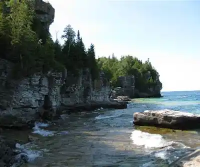
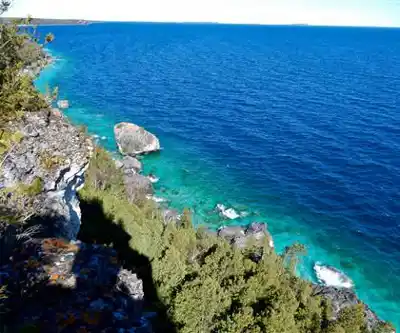
The Bruce Peninsula is essentially the exposed edge of the Niagara Escarpment, a massive ridge of sedimentary rock that once formed the floor of a shallow tropical sea. What you're walking on here — limestone, dolomite, fossilized coral — is hundreds of millions of years old. Wave action, freeze-thaw cycles, and centuries of weathering have carved this rock into caves, overhangs, and cliff faces that drop straight into Georgian Bay's turquoise water.
The limestone bedrock shapes everything about the hiking experience in this park. It creates the dramatic coastal formations, the cave systems, and the uneven, sometimes slippery terrain underfoot. It also explains why ancient cedars — some over 1,000 years old — grow sideways out of cliff cracks, their roots finding purchase where almost nothing else can survive. These trees are among the oldest living organisms in eastern North America, and they're easy to walk past without realizing what you're looking at.
Key Trails and Destinations
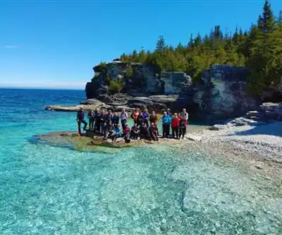
Cyprus Lake serves as the main trailhead and hub for the park's most-visited routes. From here, you can reach the Grotto, Indian Head Cove, and Overhanging Point — the three destinations that draw the bulk of the park's visitors. The trail to the Grotto and Indian Head Cove is one of the most popular hikes in Ontario, and for good reason: the combination of sea caves, clear water, and cliff scenery is genuinely spectacular. The route is accessible to most hikers, though the rocky coastal section demands solid footwear. Wet limestone is extremely slippery, and hiking boots with good grip are not optional here — they're necessary.
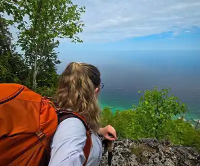
Overhanging Point delivers one of the park's most memorable viewpoints. The formation is a massive bowl carved into the cliff face, and standing at its edge gives you an unobstructed look over Georgian Bay. It's one of the most photographed spots in the park, and the short approach from Cyprus Lake makes it easy to include in a day hike without committing to a long route.
For a different character entirely, the eastern shore trail around Horse Lake takes you away from the coastal drama and into the peninsula's inland ecosystems. The terrain is quieter here, the forest denser, and the experience more contemplative. It's a good option for hikers who want to see the park's ecological diversity beyond the cliff-and-bay scenery that dominates the western shore.
The Bruce Trail runs through the park as well, connecting it to a broader 840-kilometre trail system that stretches across Ontario. The park section represents some of the finest hiking on the entire trail, and many hikers choose to focus specifically on this stretch rather than attempting longer multi-week sections.
Wildlife and Ecosystems
The park's position between Georgian Bay and Lake Huron creates microclimates that support an unusual mix of northern and southern species. The exposed cliff edges host plants more typical of boreal environments, while the sheltered inland areas support species you'd expect further south. This ecological overlap is part of what earned the Bruce Peninsula its designation as a UNESCO World Biosphere Reserve in 1990 — one of twelve such reserves in Canada.
The mixed forests, wetlands, and coastal habitats support a wide range of wildlife. The park is particularly well known among birders, and the limestone terrain supports a number of rare plant species adapted to the thin, alkaline soils. The ancient cliff-face cedars are perhaps the most visually striking element of the park's natural heritage, but the biodiversity extends well beyond what's immediately visible from the trail.
Practical Considerations
The park attracts over 400,000 visitors annually, and the most popular trails — particularly the route to the Grotto — can get genuinely crowded during summer weekends. Arriving early in the morning makes a real difference, both for parking and for experiencing the coastal sections without heavy foot traffic.
Weather along the exposed Georgian Bay shoreline can shift quickly. The open water generates its own conditions, and what starts as a clear morning can turn overcast and windy by afternoon. Layers are worth carrying regardless of the forecast, and the limestone surfaces become significantly more hazardous when wet — this is worth keeping in mind if rain is in the picture.
Cyprus Lake provides parking and basic facilities for day hikers. The park also offers camping for those wanting to extend their stay and explore beyond the most accessible trails. Reservations are strongly recommended during peak season, as the park fills up quickly and walk-in availability is limited.
The Bruce Trail Conservancy maintains the trail corridor in partnership with the park, and the route crosses a mix of public land and private property in places. Staying on marked trails and respecting Leave No Trace principles is both a practical and ethical requirement here — the park's ecological integrity depends on it.
Recommended gear for this trail


Ready to go?
Everything you need to know before you goStarting Point
To access the hiking trails in this area, you can start at several trailheads. One primary starting point is the Cyprus Lake Campground, located at 469 Cyprus Lake Road, Tobermory, Ontario. This location offers parking facilities and serves as a gateway to various trails within the park. Another option is the Halfway Log Dump Trailhead, which can be found at 7200 Highway 6, Tobermory, Ontario. Both locations provide convenient access to explore the natural beauty of the region's trails.
When?
How much?
- Hiking shoes Essential
- → Salomon Elixir Tour Mid WP · 203.38 $
- Layered clothing Essential
- Rain jacket Essential
- Trekking poles
- → Black Diamond Trail Ergo Cork · 69.99 $
- Headlamp
- → Petzl Actik Core 625 · 103.95 $
FAQ - Frequently asked questions
Everything you need to knowThe Essential Hiking Checklist
Everything you need for your next hike. Bilingual, printable, 1 page.
Download the free checklistSimilar hikes nearby
Discover other trails you might enjoy

Cabot Head Provincial Park
Bruce Peninsula, Southern Georgian Bay and Lake Simcoe
Head of Trails, Flowerpot Island
Bruce Peninsula, Southern Georgian Bay and Lake Simcoe
Hoggs Falls
Bruce Peninsula, Southern Georgian Bay and Lake Simcoe
The Grotto, Bruce Peninsula National Park
Bruce Peninsula, Southern Georgian Bay and Lake Simcoe
Lion’s Head Lookout Trail
Bruce Peninsula, Southern Georgian Bay and Lake Simcoe
Pretty River Valley Provincial Park
Bruce Peninsula, Southern Georgian Bay and Lake Simcoe
Hiking near Barrie
146 trails to explore ~161 km away
We work hard to provide the most up-to-date and error-free data possible. If something seems incorrect, let us know! Your contribution helps the whole community.
Hikers' opinions