

Ready to explore Sleeping Giant Provincial Park? Here's everything you need to know before you go!
Discover the trail
Trail description
Description
The Kabeyun Trail is one of the most rewarding long-distance hikes in Northwestern Ontario, winding through the rugged backcountry of Sleeping Giant Provincial Park on the Sibley Peninsula, which juts dramatically into Lake Superior northeast of Thunder Bay. This is big wilderness — exposed ridgelines, dense boreal forest, and the kind of silence that reminds you just how far you are from anything urban.
The Trail
Stretching approximately 80 kilometres, the Kabeyun Trail forms the backbone of Sleeping Giant Provincial Park's backcountry trail network. It runs along the western and southern edges of the peninsula, connecting a series of backcountry campsites and offering access to some of the park's most dramatic terrain. The elevation gain along the route is around 240 metres, which keeps it in the moderate difficulty range overall — but don't let that fool you. The cumulative distance means this trail is best approached as a multi-day backpacking trip rather than a day hike. Hikers who attempt the full route typically plan for several days on the trail, pacing themselves between the designated backcountry campsites spaced along the way.
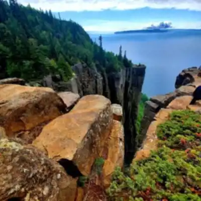
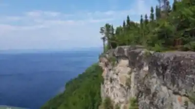
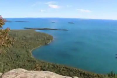
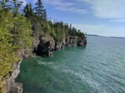
The terrain shifts as you move through the park. You'll cross open rocky headlands with sweeping views over Lake Superior, drop into sheltered valleys thick with spruce and birch, and pick your way along shoreline sections where the lake feels enormous and close at the same time. The Sleeping Giant formation itself — the mesa-like silhouette visible from Thunder Bay — takes on a completely different character when you're hiking through it rather than looking at it from a distance.
What to Expect on the Ground
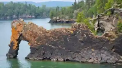
The trail is well-established but genuinely backcountry in character. Expect rooted and rocky sections, some wet areas depending on the season, and stretches where you'll want to pay attention to trail markers. The western shoreline sections along Lake Superior are among the most memorable parts of the route — the lake's scale is hard to fully appreciate until you're standing at the water's edge with nothing but open water in front of you.
Backcountry campsites along the Kabeyun Trail require a permit, which you'll need to arrange through Ontario Parks before heading out. Sites are spaced to allow reasonable daily distances, but planning your itinerary in advance is important, especially during peak summer weekends when permits can fill up.
Access and Logistics
Sleeping Giant Provincial Park is accessible via Highway 587 off the Trans-Canada Highway (Highway 11/17), roughly an hour's drive east of Thunder Bay. The park charges a daily vehicle permit fee for entry. There are multiple trailheads within the park depending on which section of the Kabeyun Trail you're targeting — the main park office can provide current maps and trail conditions.
Water sources exist along the route, but all backcountry water should be treated before drinking. Bear canisters or proper food storage are strongly recommended given the active wildlife in the park. Black bears are present throughout the peninsula.
Best Seasons
The Kabeyun Trail is typically accessible from late spring through early fall. Late June through September tends to offer the most reliable conditions, though Lake Superior's influence keeps temperatures cooler than you might expect even in midsummer — bring layers regardless of the forecast. Early season hikers should be prepared for muddy sections and potentially high water crossings. Fall brings exceptional colour to the boreal forest and fewer people on the trail.
Who This Trail Is For
The Kabeyun Trail is best suited to hikers who are comfortable with multi-day backcountry travel and self-sufficient in the wilderness. The moderate difficulty rating reflects the terrain rather than the overall commitment — completing the full 80 kilometres requires solid fitness, proper gear, and good trip planning. That said, it's also possible to access shorter sections of the trail for day hikes or overnight trips, making parts of the route accessible to a wider range of experience levels.
If you're looking for a long-distance trail in Ontario that delivers genuine wilderness character, serious Lake Superior scenery, and the satisfaction of earning your views, the Kabeyun Trail in Sleeping Giant Provincial Park is one of the best options in the province.
Recommended gear for this trail


Ready to go?
Everything you need to know before you goStarting Point
To access the hiking trails, you can start at the Kabeyun Trailhead located within Sleeping Giant Provincial Park. The primary trailhead is accessible from the Marie Louise Lake Campground area. You can reach this area by driving along Highway 587 until you enter the park. Follow signs to the Marie Louise Lake Campground, where parking is available for hikers. This is the main starting point for accessing the trail network in the park.
When?
How much?
- Hiking shoes Essential
- → Salomon Elixir Tour Mid WP · 203.38 $
- Layered clothing Essential
- Rain jacket Essential
- Trekking poles
- → Black Diamond Trail Ergo Cork · 69.99 $
- Headlamp
- → Petzl Actik Core 625 · 103.95 $
FAQ - Frequently asked questions
Everything you need to knowThe Essential Hiking Checklist
Everything you need for your next hike. Bilingual, printable, 1 page.
Download the free checklistSimilar hikes nearby
Discover other trails you might enjoy

Quetico Provincial Park
Northwestern Ontario
Ouimet Canyon Provincial Park
Northwestern Ontario
Rushing River Provincial Park
Northwestern Ontario
Kakabeka Falls Provincial Park
Northwestern Ontario
Rainbow Falls Provincial Park, Rossport Campground
Northwestern Ontario
Nagagamisis Provincial Park
Northwestern Ontario
Hiking near Winnipeg
17 trails to explore ~631 km away
We work hard to provide the most up-to-date and error-free data possible. If something seems incorrect, let us know! Your contribution helps the whole community.
Hikers' opinions