

Ready to explore Charleston Lake Provincial Park? Here's everything you need to know before you go!
Discover the trail
Oh no! We don't have any photos 😢
This trail hasn't been captured yet. Be the first to share your adventure!Trail description
Description
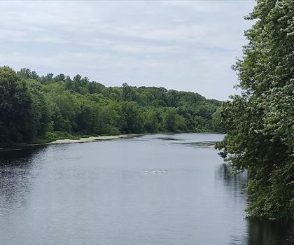
Charleston Lake Provincial Park sits in the heart of South Eastern Ontario, where Canadian Shield granite, mixed forest, and clear lake water come together in a way that's hard to find anywhere else in the region. The park covers 2,400 hectares and offers a trail system spanning over 26 kilometers, giving hikers everything from easy shoreline walks to routes that demand a bit more from your legs and lungs.
What sets Charleston Lake apart is the variety packed into a relatively compact area. Within a single outing, you can move through mature hardwood forest, scramble over open granite ridges, and arrive at a quiet bay where the water is clear enough to see the rocky bottom. That kind of landscape diversity keeps the experience interesting from start to finish.
The Trails
The Tallow Rock Bay Trail is the park's flagship route—a 10-kilometer loop that covers the full range of what Charleston Lake has to offer. The trail starts in mixed forest where sugar maple, oak, and pine share the canopy, then climbs onto rocky Canadian Shield terrain where you get your best elevated views of the lake's island-dotted surface. The descent brings you back into softer forest floor and eventually to the quiet shoreline of the bay itself.
The granite sections of Tallow Rock Bay involve some light scrambling—nothing technical, but enough to keep you paying attention. Wet rock can be slippery, so boots with solid tread are worth wearing. The payoff for the effort is real: the views from the ridges are among the best in the park, and the transition from open rock back into shaded forest has a satisfying rhythm to it.
For a shorter outing, the Sandstone Island Trail covers 2.6 kilometers along the shoreline through mixed forest. It's well-graded and stays close to the water, with multiple spots to stop and watch for wildlife. This is a good option for families, newer hikers, or anyone who wants to spend more time looking around than covering ground.
Terrain and What to Expect
The park's terrain reflects its position on the Canadian Shield. Exposed granite outcrops appear throughout, sometimes as open ridges with wide views, sometimes as slabs that slope directly into the lake. The forest composition shifts as you move through different sections—dense hardwood stands give way to areas where white pine and hemlock dominate, creating noticeably different light and atmosphere underfoot.
Elevation changes are present throughout the park. Even on shorter routes, you'll encounter enough up-and-down to feel it by the end of the day. The 100-meter elevation gain on the trails is modest but consistent, and the uneven granite surfaces mean your ankles and knees are working even when the grade is gentle.
Wildlife and the Lake
Charleston Lake itself is the defining feature of the park. It stretches across a significant portion of the park's area, dotted with small islands and edged by shoreline that alternates between sandy beaches and granite slabs. The water quality is excellent, and the lake's clarity makes it easy to spot the rocky bottom in shallower areas near the shore.
Wildlife viewing is consistently good here. White-tailed deer are common, especially in the early morning and late afternoon near open areas close to the water. The mixed forest habitat draws a wide range of bird species—pileated woodpeckers are a regular presence, and during migration periods the warbler activity can be impressive. Loons are a fixture on the lake, and great blue herons are frequently spotted fishing in the shallows along the trail corridors.
The lake also supports canoeing and kayaking, and several hiking trails connect directly to launch points. Combining a morning hike with an afternoon paddle is a natural way to structure a full day in the park. Designated swimming areas are available, and the water stays cool enough in summer to make a post-hike swim genuinely refreshing.
Camping and Multi-Day Visits
The park operates several campgrounds that are well-integrated into the natural setting—sites are tucked among the trees rather than arranged in open rows. Both tent and RV sites are available, with washrooms, showers, and potable water on site. Campgrounds connect directly to the trail system, which makes early morning starts easy and gives you access to the quieter hours when wildlife activity is highest.
If you're planning to tackle the longer trails or want to explore different sections of the park without rushing, staying overnight is worth it. The difference between arriving at the trailhead at 7 a.m. as a camper versus driving in mid-morning as a day visitor is noticeable, both in terms of wildlife encounters and trail congestion.
Planning Your Visit
Charleston Lake Provincial Park operates seasonally, generally from late spring through early fall. The trails are in their best condition during this window, and the park's maintenance schedule aligns with it. Peak summer weekends—particularly in July and August—bring heavier use to the campgrounds and the Tallow Rock Bay Trail. Getting an early start on those days makes a real difference for parking and for the quality of your time on the trail.
The park suits most hikers, but the longer routes require reasonable fitness and footwear with good grip. Wet conditions make the granite sections more demanding, and the cumulative elevation changes across a full day of hiking add up more than the numbers might suggest on paper.
Recommended gear for this trail


Ready to go?
Everything you need to know before you goStarting Point
The start of the trails at the charleston lake provincial park can be accessed by travelling east on Highway 6 from Kingston, Ontario. The park is located approximately 60 kilometres from Kingston.
When?
How much?
- Hiking shoes Essential
- → Salomon Elixir Tour Mid WP · 203.38 $
- Layered clothing Essential
- Rain jacket Essential
- Trekking poles
- → Black Diamond Trail Ergo Cork · 69.99 $
- Headlamp
- → Petzl Actik Core 625 · 103.95 $
FAQ - Frequently asked questions
Everything you need to knowThe Essential Hiking Checklist
Everything you need for your next hike. Bilingual, printable, 1 page.
Download the free checklistSimilar hikes nearby
Discover other trails you might enjoy

Mountain Orchards
South Eastern Ontario
Thousand Islands National Park
South Eastern Ontario
Sandbanks Provincial Park.
South Eastern Ontario
Jones Creek Trails - Thousand Islands National Park
South Eastern Ontario
North Grenville Rail Trail
South Eastern Ontario
Marble Rock
South Eastern Ontario
Hiking near Ottawa
47 trails to explore ~106 km away
We work hard to provide the most up-to-date and error-free data possible. If something seems incorrect, let us know! Your contribution helps the whole community.
Hikers' opinions