

Ready to explore Marble Rock Conservation Area? Here's everything you need to know before you go!
Discover the trail

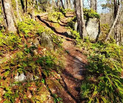
Trail description
Description
Marble Rock Conservation Area sits quietly in the rolling landscape of South Eastern Ontario, just a short drive from Kingston. This 12-kilometer network of well-maintained trails cuts through some of the region's most varied terrain, making it a solid choice whether you're breaking in new hiking boots or looking for a familiar loop close to the city.
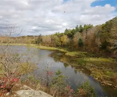
The trail system here feels more substantial than many conservation areas in the region. You're not just walking through one type of landscape—the paths wind from dense hardwood forests into rocky Canadian Shield outcroppings, then drop down into wetland areas where the footing changes and the sounds shift from rustling leaves to the calls of red-winged blackbirds. This variety keeps the hiking interesting and gives you a genuine sense of exploring rather than just following a predictable loop.
Trail Experience and Terrain
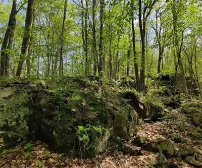
The trails at Marble Rock are well-marked and maintained, but they're not manicured. You'll encounter root systems crossing the path, occasional muddy sections near the wetlands, and some rocky scrambles that require attention to foot placement. The rocky outcrops that give the area its name create natural staircases and viewing platforms, though the rock can be slippery when wet.
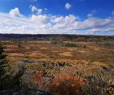
Several lookout points along the trail system offer panoramic views across the surrounding countryside. These aren't dramatic cliff-edge vistas, but rather elevated perspectives that let you see how the conservation area fits into the broader landscape of southeastern Ontario. The viewpoints make natural rest stops and photo opportunities, particularly during fall when the hardwood canopy creates layers of color stretching to the horizon.
The wetland sections provide a different hiking experience entirely. Here, the trail often follows boardwalks or raised paths that keep you dry while giving you close access to marsh environments. The contrast between walking through dense forest and emerging into open wetland areas creates a sense of discovery that many hikers find rewarding.
Wildlife and Natural Features
Marble Rock supports a healthy population of white-tailed deer and wild turkeys, both of which you're likely to encounter if you hike quietly, especially in early morning or late afternoon. The varied habitats—forest, wetland, and rocky areas—attract different bird species throughout the seasons. Spring and summer bring vibrant wildflowers along many trail sections, particularly in clearings and along wetland edges.
The geological features here tell the story of this region's ancient past. The rock formations represent millions of years of geological activity, creating interesting textures and patterns that geology enthusiasts will appreciate. Even if rocks aren't your primary interest, the way these formations shape the landscape and create microclimates adds character to the hiking experience.
Planning Your Visit
The trail network accommodates different hiking preferences and time constraints. You can design shorter loops if you're hiking with children or want a quick nature break, or link sections together for a longer day on the trails. The well-maintained condition means the trails are accessible to hikers with basic fitness levels, though the rocky sections and elevation changes provide enough challenge to keep experienced hikers engaged.
Sturdy footwear is essential here. The combination of rocky terrain, root systems, and potentially muddy wetland approaches means ankle support and good traction will make your hike more enjoyable and safer. The trails can be slippery when wet, particularly on the rock surfaces, so plan accordingly if rain is in the forecast.
Bring plenty of water, especially during warmer months. While the forest canopy provides shade on much of the trail system, the rocky areas and lookout points offer little protection from sun, and the varied terrain can be more demanding than it initially appears. A map or GPS device adds confidence, though the trail marking system is reliable.
The conservation area's location near Kingston makes it accessible for day trips from the city, but it feels genuinely removed from urban environments once you're on the trails. This balance between accessibility and natural immersion makes Marble Rock particularly valuable for people seeking regular outdoor experiences without lengthy travel times.
Recommended gear for this trail


Ready to go?
Everything you need to know before you goStarting Point
The Marble Rock is located in the town of Marble Rock, which is in the province of Ontario. To get to the start of the trails at the Marble Rock, you would need to drive to Marble Rock and then park in the town's parking lot. From there, you would need to walk to the start of the trails.
When?
How much?
- Hiking shoes Essential
- → Salomon Elixir Tour Mid WP · 203.38 $
- Layered clothing Essential
- Rain jacket Essential
- Trekking poles
- → Black Diamond Trail Ergo Cork · 69.99 $
- Headlamp
- → Petzl Actik Core 625 · 103.95 $
FAQ - Frequently asked questions
Everything you need to knowThe Essential Hiking Checklist
Everything you need for your next hike. Bilingual, printable, 1 page.
Download the free checklistSimilar hikes nearby
Discover other trails you might enjoy

Mountain Orchards
South Eastern Ontario
Thousand Islands National Park
South Eastern Ontario
Sandbanks Provincial Park.
South Eastern Ontario
Jones Creek Trails - Thousand Islands National Park
South Eastern Ontario
Charleston Lake Provincial Park
South Eastern Ontario
North Grenville Rail Trail
South Eastern Ontario
Hiking near Ottawa
47 trails to explore ~120 km away
We work hard to provide the most up-to-date and error-free data possible. If something seems incorrect, let us know! Your contribution helps the whole community.
Hikers' opinions