

Ready to explore Fanshawe Park Rd E? Here's everything you need to know before you go!
Discover the trail
Oh no! We don't have any photos 😢
This trail hasn't been captured yet. Be the first to share your adventure!Trail description
Description
Fanshawe Park Rd E is a long, multi-use trail corridor running through the heart of Southwest Ontario, near London. With a total distance of 104 km and a very gentle elevation gain of just 30 m, this is an easy route that's well-suited for walkers, cyclists, and hikers who want to cover ground without dealing with significant climbs. The flat, accessible nature of the trail makes it a go-to option for people of all fitness levels — whether you're out for a casual morning walk or looking to log serious kilometres over multiple sessions.
The Terrain and Surroundings
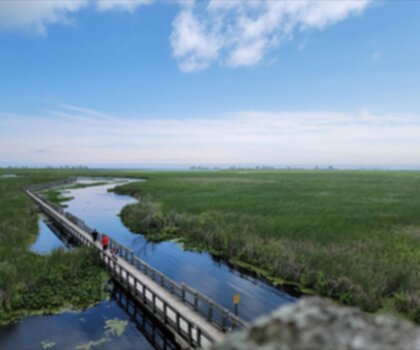
The trail passes through a mix of natural environments typical of Southwest Ontario — open meadows, wooded stretches, and areas that border the Fanshawe Conservation Area. The conservation area itself spans over 3,000 acres and includes Fanshawe Lake, so portions of the route offer views of open water and the quieter, more natural edges of the lake. The landscape here is gentle and pastoral, with the kind of scenery that rewards a slow pace — you're not chasing a summit, you're moving through a living, breathing slice of Ontario countryside.
The forested sections provide shade and a sense of seclusion even when you're not far from the city. Wildlife sightings are common along this corridor — deer, foxes, and a solid variety of bird species are regularly spotted by people who take the time to look. If you're into birdwatching, the areas near the lake and wetland edges are particularly productive.
Fanshawe Lake Trail
One of the standout features accessible from this corridor is the Fanshawe Lake Trail, a 20-kilometre loop that circles the lake. This loop is a favourite for hikers who want a more defined, immersive experience — it combines forested paths with open meadow sections and delivers consistent views of the water throughout. The loop is manageable for beginners while still offering enough variety to keep experienced hikers engaged.
Pioneer Village
If you want to add some context to your outing, the nearby Fanshawe Pioneer Village is worth a stop. It's a living history museum that recreates 19th-century Ontario life through authentic heritage buildings and hands-on demonstrations. It's a genuinely interesting complement to a day spent outdoors — especially if you're bringing kids or have an interest in local history.
Planning Your Visit
Because the trail stretches 104 km, most people don't tackle it in a single outing. The flat terrain and easy difficulty rating make it ideal for breaking into sections — you can pick an access point, head out for a few hours, and come back another day to explore a different stretch. There's no need to rush through it, and the variable duration reflects that flexibility.
- Distance: 104 km total
- Elevation gain: 30 m
- Difficulty: Easy
- Duration: Variable depending on section chosen
- Location: Southwest Ontario, near London, Ontario
The low elevation change means the trail is accessible to a wide range of people, including those who are newer to hiking or prefer a more relaxed pace. Bring water, wear comfortable footwear, and take your time — this is the kind of trail that rewards people who aren't in a hurry.
Recommended gear for this trail


Ready to go?
Everything you need to know before you goStarting Point
The easiest way to get to the start of the trails at the fanshawe park rd e in Ontario is to drive there.
When?
How much?
- Hiking shoes Essential
- → Salomon Elixir Tour Mid WP · 203.38 $
- Layered clothing Essential
- Rain jacket Essential
- Trekking poles
- → Black Diamond Trail Ergo Cork · 69.99 $
- Headlamp
- → Petzl Actik Core 625 · 103.95 $
FAQ - Frequently asked questions
Everything you need to knowThe Essential Hiking Checklist
Everything you need for your next hike. Bilingual, printable, 1 page.
Download the free checklistSimilar hikes nearby
Discover other trails you might enjoy

Lynn Valley Trails
Southwest Ontario
Point Pelee National Park High Point, Ontario
Southwest Ontario
Oxford Thames River Trail
Southwest Ontario
Pinery Provincial Park
Southwest Ontario
Ojibway Prairie Provincial Nature Reserve
Southwest Ontario
Springbank Park
Southwest Ontario
Hiking near Kitchener
142 trails to explore ~75 km away
We work hard to provide the most up-to-date and error-free data possible. If something seems incorrect, let us know! Your contribution helps the whole community.
Hikers' opinions