

Ready to explore Gypsum Mine Tract Trailhead? Here's everything you need to know before you go!
Discover the trail
Oh no! We don't have any photos 😢
This trail hasn't been captured yet. Be the first to share your adventure!Trail description
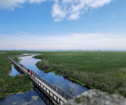
The Gypsum Mine Tract Trailhead is the main entry point into a trail network shaped by Southwest Ontario's industrial past and natural recovery. Located near Caledonia in Haldimand County, the trailhead is easy to find and straightforward to reach by vehicle, which makes it a practical choice for both local regulars and first-time visitors to the area.
The parking area is large enough to handle a solid turnout on busy weekends, and a trail map posted at the trailhead gives you a clear picture of the full network before you head out. Taking a few minutes to study it is worth the effort — the system offers multiple route options, and knowing what's available helps you pick the right one for your group and your available time.
The Trail Experience
The featured route here covers 2.5 kilometres with about 50 metres of elevation gain, rated Easy and typically completed in around one hour. That profile makes it genuinely accessible — families with kids, casual hikers, and people easing back into outdoor activity will all find it manageable without feeling like it's too flat to be interesting. The modest elevation change gives the route just enough variety to keep things engaging without pushing anyone into uncomfortable territory.
What makes the Gypsum Mine Tract stand out from a typical easy trail is the landscape itself. The terrain here was shaped by historical mining activity, and the land has been reclaiming itself ever since. That process creates a patchwork of environments — recovering open areas, maturing forest sections, and the kind of varied ground cover that comes from different soil conditions left behind by past disturbance. It's not a manicured park trail, and that's part of the appeal.
Trail Marking and Navigation
The trail marking throughout the tract is consistent and well-maintained. Blazes and signage are clear enough that you can move through the network without constantly second-guessing your route, which is especially helpful if you're exploring the area for the first time. The trailhead map identifies connections between routes, difficulty levels, and key landmarks, so you can plan a loop or extend your outing if the shorter route leaves you wanting more.
That said, carrying a backup — whether that's a downloaded map on your phone or a paper copy — is always a reasonable habit regardless of how well-marked a trail system is.
Wildlife and Natural Features
The mix of recovering habitat and established forest supports a range of wildlife, and the varied plant communities that come with different soil types and light conditions add genuine interest to the walk. The tract's history of industrial use followed by natural recovery means you're moving through a landscape that's still actively changing, which gives observant hikers something to notice beyond just the physical exercise.
Early morning starts tend to offer the best conditions for spotting wildlife, and they also mean you'll have the trails largely to yourself during busier periods.
Getting There and Practical Notes
Access to the Gypsum Mine Tract near Caledonia is straightforward, and road signage makes the area easy to identify. The large parking area means you're unlikely to arrive and find yourself circling for a spot, though earlier in the day is always the better bet during peak seasons.
The trail system works well for mixed-ability groups. The easy route described here gives less experienced hikers a comfortable and rewarding outing, while the broader network within the tract includes more challenging options for anyone looking to push further. That range makes the Gypsum Mine Tract Trailhead a flexible destination — useful whether you're introducing someone to hiking for the first time or looking for a quick, satisfying outing close to home in Southwest Ontario.
Recommended gear for this trail


Ready to go?
Everything you need to know before you goStarting Point
The gypsum mine tract trailhead is located in Ontario, California. To get there, take the I-15 freeway to the Jurupa Street exit and go east. Turn left on Mission Boulevard and drive north for about 1.5 miles. Turn right on Etiwanda Avenue and drive east for about 0.5 mile. The trailhead will be on your left.
When?
How much?
- Hiking shoes Essential
- → Salomon Elixir Tour Mid WP · 203.38 $
- Layered clothing Essential
- Rain jacket Essential
- Trekking poles
- → Black Diamond Trail Ergo Cork · 69.99 $
- Headlamp
- → Petzl Actik Core 625 · 103.95 $
FAQ - Frequently asked questions
Everything you need to knowThe Essential Hiking Checklist
Everything you need for your next hike. Bilingual, printable, 1 page.
Download the free checklistSimilar hikes nearby
Discover other trails you might enjoy

Lynn Valley Trails
Southwest Ontario
Point Pelee National Park High Point, Ontario
Southwest Ontario
Oxford Thames River Trail
Southwest Ontario
Pinery Provincial Park
Southwest Ontario
Ojibway Prairie Provincial Nature Reserve
Southwest Ontario
Springbank Park
Southwest Ontario
Hiking near Hamilton
162 trails to explore ~21 km away
We work hard to provide the most up-to-date and error-free data possible. If something seems incorrect, let us know! Your contribution helps the whole community.
Hikers' opinions