

Ready to explore Lake Whitaker? Here's everything you need to know before you go!
Discover the trail
Oh no! We don't have any photos 😢
This trail hasn't been captured yet. Be the first to share your adventure!Trail description
Description
Lake Whitaker sits quietly in Southwest Ontario's countryside, offering a refreshing alternative to the region's busier conservation areas. This peaceful lake draws hikers and outdoor enthusiasts with its combination of accessible trails, clear waters, and the kind of unhurried atmosphere that's increasingly hard to find close to urban centers.
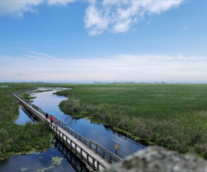
The landscape feels distinctly southwestern Ontario — rolling terrain covered in mixed hardwood forests that transition to open meadows and wetland edges near the water. The lake itself serves as the centerpiece, its clear surface reflecting the surrounding greenery and creating those picture-perfect moments that make you pause mid-stride.
The Hike
The main loop at Lake Whitaker covers 2.5 km with just 20 m of elevation gain, making it a genuinely easy outing that most people can complete comfortably in around 1 hour 15 minutes. That low elevation change means the trail never feels like a workout — the gentle undulations are enough to keep things interesting without pushing anyone into uncomfortable territory.
The Lake Whitaker Loop is the signature route, taking you around the water's perimeter with consistently good views throughout. The format works well: you're always moving toward new scenery rather than retracing your steps, and the combination of shoreline walking and light woodland climbing gives the hike a natural rhythm. The lakeshore sections stay close enough to the water that you can hear it and spot fish moving in the shallows, while the wooded stretches pull you into dense stands of maple, oak, and birch where the canopy closes overhead.
The woodland portions involve the modest elevation changes that account for most of that 20 m gain — nothing strenuous, but enough to earn you slightly elevated perspectives over the lake and the countryside beyond before the trail drops back down to the water's edge.
Terrain and Trail Conditions
The trail surface varies between the shoreline and forest sections. Along the water, the path is relatively flat and easy underfoot. The woodland stretches are more typical forest trail — rooted in places, with the kind of natural surface that rewards paying attention to where you step. Standard hiking footwear handles everything here without issue, though waterproof boots are worth considering after rain or during spring when the lakeshore sections can hold moisture and turn muddy.
The easy difficulty rating makes this a solid choice for families with younger kids, anyone returning to hiking after a break, or visitors who want a peaceful nature walk without committing to a demanding route. The short distance also means you can take your time — stop at the water's edge, watch for wildlife, eat lunch on a log — without worrying about finishing before dark.
Wildlife and Natural Features
Lake Whitaker's mix of habitats — open water, wetland edges, meadows, and mature forest — creates good conditions for wildlife watching. Deer are commonly spotted, particularly during early morning or evening visits when they come to the water to drink. Moving quietly through the area significantly improves your chances of seeing them before they notice you.
Rabbits move through the underbrush along the trail edges, and the bird life reflects the habitat variety. Waterfowl use the lake through the warmer months, while the forested sections support woodpeckers, nuthatches, and a range of songbirds. Spring and fall migration periods bring additional species through, making those seasons particularly worthwhile for anyone who pays attention to birds.
The lake's water quality supports a healthy fish population — you'll often see fish rising to feed near the surface, especially during the calmer periods around dawn and dusk when the water is at its most still.
Beyond the Trail
Hiking is the main draw, but Lake Whitaker lends itself to a fuller outdoor day. The fishing is genuinely worthwhile, and the lake's size makes it well-suited to kayaking and canoeing — manageable for paddlers of different skill levels, with the protected location keeping wind and wave conditions reasonable. Combining a paddle with the loop hike gives you two very different perspectives on the same place: the intimate shoreline view from water level, and the broader landscape from the elevated trail sections.
Several designated picnic areas are positioned to take advantage of lake views, making it easy to extend your visit beyond just hiking time. The setting is calm enough that these spots work well for a proper sit-down meal rather than just a quick snack break.
Getting the Most Out of Your Visit
Lake Whitaker's location in Southwest Ontario makes it accessible for a day trip without requiring much advance planning — the kind of place you can decide to visit on a Saturday morning and be on the trail within a reasonable drive. Early morning visits tend to offer the best wildlife activity and the calmest water conditions, with the lake surface often going mirror-flat before any wind picks up. Photographers will find the combination of water reflections, forest light, and wildlife provides varied subject matter, particularly during the golden hours when the light hits the lake at a low angle.
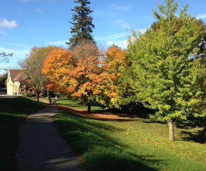
Fall is especially rewarding here — the mixed hardwood forest puts on a strong color display, and the cooler temperatures make the short loop feel brisk and energizing rather than leisurely.
Recommended gear for this trail


Ready to go?
Everything you need to know before you goStarting Point
To access the hiking trails, head to the main trailhead located at 5840 Elgin Road, Belmont, Ontario. This is the primary parking area for visitors. If you're coming from London, Ontario, take Highway 401 eastbound and exit at Dorchester Road (Exit 203). Follow Dorchester Road south until you reach Elgin Road, then turn left and continue until you arrive at the parking lot.
When?
How much?
- Hiking shoes Essential
- → Salomon Elixir Tour Mid WP · 203.38 $
- Layered clothing Essential
- Rain jacket Essential
- Trekking poles
- → Black Diamond Trail Ergo Cork · 69.99 $
- Headlamp
- → Petzl Actik Core 625 · 103.95 $
FAQ - Frequently asked questions
Everything you need to knowThe Essential Hiking Checklist
Everything you need for your next hike. Bilingual, printable, 1 page.
Download the free checklistSimilar hikes nearby
Discover other trails you might enjoy

Lynn Valley Trails
Southwest Ontario
Point Pelee National Park High Point, Ontario
Southwest Ontario
Oxford Thames River Trail
Southwest Ontario
Pinery Provincial Park
Southwest Ontario
Ojibway Prairie Provincial Nature Reserve
Southwest Ontario
Springbank Park
Southwest Ontario
Hiking near Kitchener
142 trails to explore ~71 km away
We work hard to provide the most up-to-date and error-free data possible. If something seems incorrect, let us know! Your contribution helps the whole community.
Hikers' opinions