

Ready to explore Orchard Park? Here's everything you need to know before you go!
Discover the trail
Oh no! We don't have any photos 😢
This trail hasn't been captured yet. Be the first to share your adventure!Trail description
Description
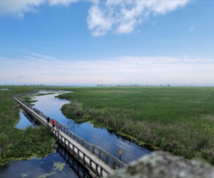
Orchard Trail is a classic Rouge Valley hike located in Scarborough within Rouge National Park. This 5.1-kilometer loop combines moderate terrain with rich environmental and historical features. The trail weaves between sections of the Cedar Trail and the primary Orchard Trail, gradually climbing the escarpment and offering encounters with wetlands, creek crossings, and remnants of early European settlement.
Trail Character and Terrain
The route gains 84 meters of elevation as it gradually climbs the escarpment, with the terrain presenting moderate challenges rather than being flat and easy. The loop follows along Little Rouge Creek for much of its length, with sections that transition from low-lying wetland areas to higher escarpment edges. The trail surface can be muddy, particularly in areas near wetlands and after rainfall, so appropriate footwear is essential. Offline maps are recommended once you depart the main Orchard Trail, as navigation becomes more complex in those sections.
The diverse landscape includes young forests mixed seamlessly with open wetland areas. The orchard sections reflect the park's historical heritage, with remnant fruit trees, old residences, and traces of an historic mill visible along the route. These cultural elements provide visual interest and context to the walk, offering glimpses into the area's early European settlement patterns.
What to Expect Along the Way
The woodland sections offer shade beneath the canopy of young forest growth. The wetland areas contrast with these forested stretches, opening the landscape and revealing the aquatic habitat that supports diverse wildlife. Little Rouge Creek accompanies much of the journey, providing a constant natural feature to follow and listen to as you walk.
The escarpment climb is gradual but noticeable, with the return route following the escarpment's edge back toward the starting point. The elevated sections provide different perspectives on the valley landscape below. Wildlife activity is notable throughout the year, with the mix of forest, wetland, and creek habitat supporting birds, amphibians, and other species.
Seasonal and Weather Considerations
Expect muddy sections and bug activity most of the year, especially when close to the low-lying areas with wetlands. Spring and early summer can be particularly buggy, so insect protection is advisable. The trail is accessible year-round, though wet conditions are common in shoulder seasons. After significant rainfall, sections near the creek and wetlands become noticeably muddier, so check conditions before visiting.
Access and Facilities
The trailhead is accessed from the parking lot off Twyne Rivers Drive. The loop can be completed in either direction, and the route benefits from being hiked in the quieter hours to maximize wildlife viewing opportunities and avoid crowds.
Recommended gear for this trail


Ready to go?
Everything you need to know before you goStarting Point
The orchard park trails are located in the town of orchard park, Ontario. To get to the start of the trails, take Highway 401 to exit 282 (County Road 2). Head north on County Road 2 for about 5 km until you reach the town of orchard park. The trailhead is located at the intersection of County Road 2 and Concession Road 10.
When?
How much?
- Hiking shoes Essential
- → Salomon Elixir Tour Mid WP · 203.38 $
- Layered clothing Essential
- Rain jacket Essential
- Trekking poles
- → Black Diamond Trail Ergo Cork · 69.99 $
- Headlamp
- → Petzl Actik Core 625 · 103.95 $
FAQ - Frequently asked questions
Everything you need to knowThe Essential Hiking Checklist
Everything you need for your next hike. Bilingual, printable, 1 page.
Download the free checklistSimilar hikes nearby
Discover other trails you might enjoy

Lynn Valley Trails
Southwest Ontario
Point Pelee National Park High Point, Ontario
Southwest Ontario
Oxford Thames River Trail
Southwest Ontario
Pinery Provincial Park
Southwest Ontario
Ojibway Prairie Provincial Nature Reserve
Southwest Ontario
Springbank Park
Southwest Ontario
Hiking near Kitchener
142 trails to explore ~83 km away
We work hard to provide the most up-to-date and error-free data possible. If something seems incorrect, let us know! Your contribution helps the whole community.
Hikers' opinions