

Ready to explore Port Burwell Provincial Park? Here's everything you need to know before you go!
Discover the trail
Oh no! We don't have any photos 😢
This trail hasn't been captured yet. Be the first to share your adventure!Trail description
Description
Port Burwell Provincial Park sits along Lake Erie's north shore in Southwest Ontario, and it delivers something genuinely uncommon for a park of its size: two completely different environments packed into a single outing. The 3.2-kilometer trail system moves between open sandy beach and dense Carolinian forest, and that contrast is what makes this place worth the trip.
Trail Experience and Terrain
The trails gain 120 meters of elevation over their length, which earns the moderate difficulty rating without ever feeling punishing. The climbs are gradual enough that hikers with basic experience will handle them comfortably, but noticeable enough that you'll feel the workout. Budget around 1 hour and 30 minutes for the full loop at a relaxed pace — though most people end up spending longer once they hit the beach.
The experience shifts noticeably as you move through the park. Near the lake, the trail runs close to one of the more substantial sandy beaches on Lake Erie's north shore — this isn't a narrow strip of shoreline but a wide, open stretch that creates a genuinely coastal feel. The wind off the water, the open sky, and the fine sand underfoot make this section feel nothing like a typical Ontario forest hike.
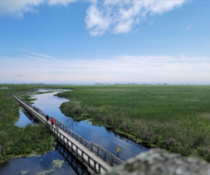
Push inland and the character changes completely. The forest closes in, the wind drops, and you're walking under a Carolinian canopy that feels almost subtropical compared to the boreal forests most Ontario hikers are used to. The understory shifts between dense fern carpets in the shadier sections and more open areas where wildflowers take over in spring. Some wetter sections are bridged with wooden boardwalks, which keeps the trail accessible without tearing up the ground.
As the trail climbs away from lake level, you'll catch occasional views back toward Lake Erie through gaps in the canopy. These aren't dramatic overlooks, but they're a good reminder of how much ground you've covered and how close the water still is.
Carolinian Forest
The forest at Port Burwell is worth understanding before you arrive, because it's genuinely different from what you'll find in most Ontario parks. Carolinian forests represent the northernmost extension of a forest type that's far more common hundreds of kilometers to the south. The species mix here — both trees and understory plants — reflects that southern influence, and the biodiversity is noticeably higher than in the mixed or boreal forests that dominate most of the province.
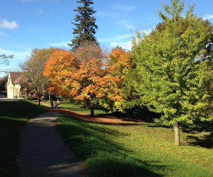
Spring is when this becomes most obvious. Wildflowers bloom in succession through April and May, and the variety of species is something that botanically-minded hikers specifically seek out. Fall brings its own payoff: the leaf color combinations here include species that don't appear in more northern forests, which gives the autumn palette a different character than what you'd see at, say, a Shield-country park.
Wildlife
Port Burwell's location on Lake Erie puts it directly in the path of migratory bird movements, and the park's mix of habitats concentrates that diversity into a small area. The forest sections hold woodland species — warblers, woodpeckers, nuthatches — while the open beach and meadow areas attract entirely different communities. The transition zones between habitats tend to be the most productive spots for birdwatchers, and the park's compact size makes it easy to work through several of those zones in a single morning.
Deer are a regular presence throughout the park. Early morning and late afternoon are the best windows for sightings, particularly in the meadow areas where they come out to graze. They're habituated enough to the park environment that patient hikers often get decent views without much effort.
Practical Information
The trail system connects directly with the park's picnic areas and campground facilities, which makes it easy to build a longer day around the hike rather than treating it as a standalone activity. Several picnic areas are positioned near the trails — some with beach access, others oriented toward the forest — so you have flexibility in how you structure your time.
For those wanting to extend the visit into an overnight or weekend trip, Port Burwell's campground offers modern amenities while keeping you close to both the trails and the beach. The setup works well as a base for multiple days of varied activity rather than just a single hike.
Historical Context
The Port Burwell Lighthouse and Marine Museum sits near the park and adds a layer to the visit that's worth factoring into your plans. The lighthouse is visible from sections of the trail, and understanding the area's history as a Lake Erie port gives some context to the landscape you're moving through. The marine museum covers the region's relationship with the lake in more depth if that history interests you.
Port Burwell Provincial Park works well as a half-day destination on its own, but the combination of beach, Carolinian forest, wildlife, and nearby historical sites gives it enough range to justify a full day or a weekend stay.
Recommended gear for this trail


Ready to go?
Everything you need to know before you goStarting Point
The start of the trails at the port burwell provincial park can be accessed by travelling east on Highway 19 from Highway 401. The park is located approximately 10 kilometres east of Highway 401.
When?
How much?
- Hiking shoes Essential
- → Salomon Elixir Tour Mid WP · 203.38 $
- Layered clothing Essential
- Rain jacket Essential
- Trekking poles
- → Black Diamond Trail Ergo Cork · 69.99 $
- Headlamp
- → Petzl Actik Core 625 · 103.95 $
FAQ - Frequently asked questions
Everything you need to knowThe Essential Hiking Checklist
Everything you need for your next hike. Bilingual, printable, 1 page.
Download the free checklistSimilar hikes nearby
Discover other trails you might enjoy

Lynn Valley Trails
Southwest Ontario
Point Pelee National Park High Point, Ontario
Southwest Ontario
Oxford Thames River Trail
Southwest Ontario
Pinery Provincial Park
Southwest Ontario
Ojibway Prairie Provincial Nature Reserve
Southwest Ontario
Springbank Park
Southwest Ontario
Hiking near Kitchener
142 trails to explore ~94 km away
We work hard to provide the most up-to-date and error-free data possible. If something seems incorrect, let us know! Your contribution helps the whole community.
Hikers' opinions