

Ready to explore Turkey Point Provincial Park? Here's everything you need to know before you go!
Discover the trail
Oh no! We don't have any photos 😢
This trail hasn't been captured yet. Be the first to share your adventure!Trail description
Description
Turkey Point Provincial Park sits along the north shore of Lake Erie in Southwest Ontario, where Carolinian forest meets one of the Great Lakes' most dramatic shorelines. This 270-hectare park delivers a rare combination: genuine forest hiking with bluff-top lake views, followed by easy access to a sandy beach. It's the kind of place where you can spend a full day and feel like you've done two completely different trips.
The park's position on the Long Point peninsula puts it in one of Ontario's most ecologically significant corners. Sandy soils, a lake-moderated climate, and the northernmost reach of the Carolinian forest zone create growing conditions unlike anywhere else in the province. The species you'll encounter here — both plant and animal — reflect a southern influence that makes Turkey Point feel distinctly different from most Ontario parks.
Trail System
The trail network at Turkey Point is well-maintained and clearly signed, making navigation easy whether you're here for a quick walk or a longer outing. Trails range from flat, easy loops through the park's interior forest to more engaging routes that climb toward the bluffs above Lake Erie.
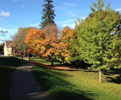
The Lookout Bluff Trail is the park's signature route and the one most worth prioritizing. It moves through mature Carolinian forest — towering oaks, maples, and hickories — before opening up at panoramic viewpoints high above the lake. The elevation gain of approximately 40 meters is enough to make the climb feel meaningful without being difficult. At the top, you get sweeping views across Lake Erie that stretch to the horizon on clear days. The western exposure also makes this a strong spot for late-afternoon light.
The park's additional trails loop through quieter interior sections, passing through different forest communities. Spring brings wildflowers carpeting the forest floor before the canopy fills in. Later in the season, the dense understory provides shade and a sense of enclosure that feels genuinely wild despite the park's relatively compact size. Trail surfaces are generally firm and well-drained, though wet weather can leave some sections muddy.
The Carolinian Forest
What sets Turkey Point apart from most Ontario parks is the forest itself. The Carolinian zone — named for the Carolinas, where this type of forest is more common — reaches its northern limit in Southwest Ontario, and Turkey Point sits right in the heart of it. The tree species here, including hickory and tulip tree alongside the more familiar maples and oaks, support a layered ecosystem that's unusually rich for this latitude.
The sandy soils that characterize the Long Point area also shape the forest character. They drain quickly, warm up fast in spring, and create conditions that favor species adapted to drier, warmer environments. Walking through this forest, you get a real sense of being somewhere ecologically distinct — not just another mixed hardwood stand, but a community of plants and animals that exists in a narrow band along Lake Erie's north shore.
Wildlife
White-tailed deer are a regular presence throughout the park, most reliably spotted during early morning and evening hours near forest clearings and trail edges. The mix of forest interior, forest edge, and shoreline habitat makes Turkey Point productive for bird watching as well. The Long Point area sits along major migratory flyways, and the park benefits from that geography — spring and fall migrations bring a wide variety of species through, and the combination of woodland and waterfront environments attracts both forest birds and waterfowl year-round.
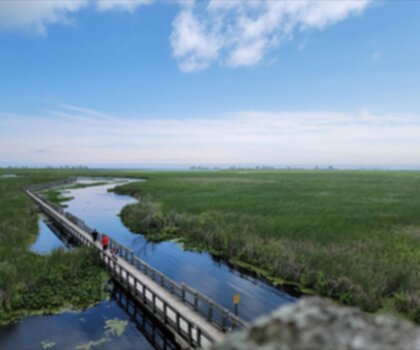
Beach and Waterfront
After the trails, Turkey Point's sandy beach along Lake Erie gives you a completely different way to spend time in the park. The beach is family-friendly, with a sandy bottom and generally accessible swimming conditions, though Lake Erie's temperature and surface conditions shift noticeably with weather and season. Picnic areas near the waterfront are well-positioned to catch lake breezes and views, making them a practical spot to eat after a morning on the trails.
The beach access is one of Turkey Point's genuine strengths as a destination. For groups where not everyone wants to hike, or for families with younger kids, having a quality swimming beach within the same park removes the usual trade-off between forest hiking and waterfront time.
Camping
Turkey Point's campground accommodates both tent campers and RVs, with facilities that support comfortable multi-night stays. The campground's proximity to both the trail system and the beach means you can structure your days around early morning hikes — when the trails are quieter and wildlife is more active — and afternoon time at the water. Evening walks along the bluff trails offer a different perspective on the lake views, particularly around sunset when the western exposure works in your favor.
Getting There and Planning Your Visit
Turkey Point Provincial Park is accessible from major Southwest Ontario urban centers including Toronto, Hamilton, and London, making it a viable day trip destination as well as a base for longer stays. That said, the combination of hiking and beach access tends to encourage people to stay longer than planned.
Trail conditions vary by season. Spring can bring muddy sections and higher water levels near the shoreline. Summer offers the best overlap of good hiking weather and swimming conditions. Fall is an excellent time to hike — the Carolinian forest produces strong fall color, and the trails are less crowded than in peak summer. Before visiting, it's worth checking Ontario Parks for current conditions, any seasonal restrictions, and campsite availability if you're planning to stay overnight.
Recommended gear for this trail


Ready to go?
Everything you need to know before you goStarting Point
The start of the trails at the turkey point provincial park in Ontario can be accessed by travelling east on Highway 3 from Woodstock. The park is located approximately 15 kilometres from Highway 3.
When?
How much?
- Hiking shoes Essential
- → Salomon Elixir Tour Mid WP · 203.38 $
- Layered clothing Essential
- Rain jacket Essential
- Trekking poles
- → Black Diamond Trail Ergo Cork · 69.99 $
- Headlamp
- → Petzl Actik Core 625 · 103.95 $
FAQ - Frequently asked questions
Everything you need to knowThe Essential Hiking Checklist
Everything you need for your next hike. Bilingual, printable, 1 page.
Download the free checklistSimilar hikes nearby
Discover other trails you might enjoy

Lynn Valley Trails
Southwest Ontario
Point Pelee National Park High Point, Ontario
Southwest Ontario
Oxford Thames River Trail
Southwest Ontario
Pinery Provincial Park
Southwest Ontario
Ojibway Prairie Provincial Nature Reserve
Southwest Ontario
Springbank Park
Southwest Ontario
Hiking near Hamilton
162 trails to explore ~72 km away
We work hard to provide the most up-to-date and error-free data possible. If something seems incorrect, let us know! Your contribution helps the whole community.
Hikers' opinions