

Ready to explore Hockley Valley? Here's everything you need to know before you go!
Discover the trail


Available trails
| Trails | Distance | Elevation | Duration | Difficulty | GPX |
|---|---|---|---|---|---|
| 14.12 km | 481 m | 4h | GPX |
Trail description
Description
Hockley Valley Provincial Park sits just outside Orangeville, about 45 minutes north of Toronto, offering hikers a chance to explore one of Ontario's most ecologically diverse areas. This 375-hectare park forms part of the Niagara Escarpment, a UNESCO World Biosphere Reserve that stretches across southern Ontario.
What makes Hockley Valley special is its incredible plant diversity. The park hosts approximately 400 vascular plant species, many of which are uncommon in Ontario. You'll find unique species like the cuckoo flower, sand violet, and butternut tree scattered throughout the landscape. The park also serves as critical habitat for several endangered species, including the northern long-eared bat, northern brook lamprey, and Jefferson salamander.
Trail Network and Hiking Experience
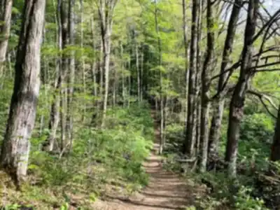
The Bruce Trail forms the backbone of Hockley Valley's trail system, winding through the park alongside several subsidiary routes that create a network of hiking options. These trails offer a moderate challenge with varied terrain that includes rolling hills, providing hikers with a solid workout while maintaining accessibility for most skill levels.
The 15-kilometer trail system features 120 meters of elevation gain and typically takes around 4 hours and 15 minutes to complete fully. The paths range from wide, comfortable walkways where you can stretch out and enjoy the scenery to narrower forest trails that wind through dense woodland areas.
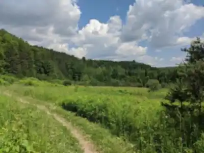
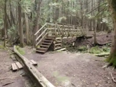
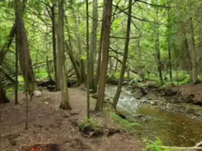
Hikers will encounter a mix of terrain as they explore the park. The trails lead through mature forests, open meadows, and alongside clear streams that cut through the landscape. The varied topography of the Niagara Escarpment creates interesting elevation changes and unique viewpoints throughout the hike.
Seasonal Highlights
Summer hiking at Hockley Valley rewards visitors with spectacular wildflower displays. The park's diverse plant communities create colorful meadows and forest understories that change throughout the growing season. The wide variety of native species means there's almost always something in bloom from late spring through early fall.
Fall transforms Hockley Valley into one of the region's premier destinations for viewing autumn colors. The mixed forest canopy creates a stunning tapestry of reds, oranges, and yellows that draws photographers and nature lovers from across the Greater Toronto Area. The combination of mature hardwoods and the park's varied elevation makes for particularly dramatic fall displays.
Wildlife and Natural Features
The park's location along the Niagara Escarpment creates diverse habitats that support an impressive array of wildlife. Beyond the endangered species that call the park home, visitors often spot various bird species, small mammals, and amphibians during their hikes. The streams and wetland areas provide excellent opportunities for wildlife observation, particularly in the early morning or late afternoon.
The geological features of the escarpment add another layer of interest to any hike. The exposed rock faces and unique landforms tell the story of ancient seas and glacial activity that shaped this landscape thousands of years ago.
Park Facilities and Access
Hockley Valley maintains its wild character by offering minimal tourist facilities. This approach preserves the natural experience while focusing resources on trail maintenance and habitat protection. The lack of developed amenities means hikers should come prepared with water, snacks, and appropriate gear for their adventure.
The park's proximity to Toronto makes it an excellent choice for day trips, while its undeveloped nature provides an authentic wilderness experience that's increasingly rare in southern Ontario. The trail system is well-marked and maintained, making navigation straightforward for hikers of various experience levels.
Conservation Context
As part of the Niagara Parks system, Hockley Valley operates under the management of a self-funded organization within Ontario's Ministry of Heritage, Sport, Tourism, and Culture Industries. This management structure ensures that conservation remains the primary focus while providing sustainable public access to this remarkable landscape.
The park's role in protecting rare and endangered species makes every visit an opportunity to experience conservation in action. The careful balance between public access and habitat protection demonstrates how provincial parks can serve both recreational and ecological functions.
Hockley Valley represents the best of what the Niagara Escarpment has to offer – diverse ecosystems, challenging terrain, and the kind of natural beauty that makes you forget you're less than an hour from Canada's largest city.
Services and amenities
This information may vary by season.
Recommended gear for this trail


Ready to go?
Everything you need to know before you goStarting Point
hockley valley Provincial Park has three loop trails and other hiking paths. You may pick how many loop paths to hike depending on your endurance and how long you want to go. hockley valley has several hills, and I'd classify this one as a moderate trek. If you're a first-time hiker, don't be discouraged. Just be aware that you'll be rising and descending often, making it more strenuous than a flat trek.
The Bruce Trail was followed for the first half of the trek. The walk runs across an open meadow and past a forestry effort on its approach to the nature reserve's northern entrance. When you reach the nature reserve, the trail takes you through a deep forest before opening up onto a meadow. They detoured at the Cam Snell Side Trail (2.2km), which runs through more open fields and meadows, as well as around two ponds, before returning to the woods. The Glen Cross Side Route (1.9km) connects with the Isabel East Side Trail to make a circle returning to the main trail. Although this portion had more undulating hills, it is undoubtedly the most gorgeous path in hockley valley. The trail descends the valley via a forested area and passes two tiny creeks. It also travels through another open area before returning to the main route through the wild land.
When?
How much?
- Hiking shoes Essential
- → Salomon Elixir Tour Mid WP · 203.38 $
- Layered clothing Essential
- Rain jacket Essential
- Trekking poles
- → Black Diamond Trail Ergo Cork · 69.99 $
- Headlamp
- → Petzl Actik Core 625 · 103.95 $
FAQ - Frequently asked questions
Everything you need to knowThe Essential Hiking Checklist
Everything you need for your next hike. Bilingual, printable, 1 page.
Download the free checklistSimilar hikes nearby
Discover other trails you might enjoy

North Maple Regional Park
York, Durham and Headwaters
Tobacco Trails
York, Durham and Headwaters
Forest Therapy Trail
York, Durham and Headwaters
Eldred King Woodlands
York, Durham and Headwaters
Vicki Barron Lakeside Trail
York, Durham and Headwaters
Wismer Park
York, Durham and Headwaters
Hiking near Guelph
166 trails to explore ~51 km away
We work hard to provide the most up-to-date and error-free data possible. If something seems incorrect, let us know! Your contribution helps the whole community.
Hikers' opinions