
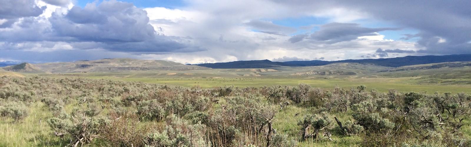

Ready to explore Rabbit Ears Pass? Here's everything you need to know before you go!
Discover the trail
Oh no! We don't have any photos 😢
This trail hasn't been captured yet. Be the first to share your adventure!Trail description
Rabbit Ears Pass is one of those places that earns its reputation the moment you arrive. Sitting along the Continental Divide in Colorado, this high-elevation corridor offers a genuine mountain experience — sweeping alpine scenery, wide open terrain, and a sense of space that's hard to find closer to the Front Range. Whether you're coming for a day hike, a snowshoe outing, or just to take in the views from the pass itself, Rabbit Ears delivers something memorable at every visit.
The Landscape
The pass takes its name from the distinctive twin rock formations that rise above the surrounding terrain — two volcanic plugs that have been landmarks for travelers crossing this stretch of the Rockies for centuries. They're visible from a good distance and serve as a natural reference point throughout your time in the area. The terrain around Rabbit Ears Pass is classic high-country Colorado: subalpine meadows, dense stands of Engelmann spruce and subalpine fir, and open ridgelines that give way to long views in multiple directions.
The elevation here means the landscape shifts noticeably with the seasons. In summer, the meadows fill in with wildflowers and the trails are generally dry and accessible. Come winter, the area transforms into one of the more popular snowshoe and cross-country ski destinations in the region, with reliable snowpack and groomed routes maintained by local organizations.
Hiking the Area
The trail network around Rabbit Ears Pass gives hikers a range of options depending on how much ground they want to cover. The most iconic objective is reaching the base of the Rabbit Ears rock formations themselves — a relatively straightforward hike that rewards you with close-up views of the volcanic spires and a broad panorama of the surrounding mountains and valleys. The trail winds through open meadows and patches of forest before opening up near the formations.
Beyond the main landmark, the area connects to a broader network of routes that explore the ridgelines and drainages of the Continental Divide. Hikers who want to push further can follow trails that trace the divide itself, with consistent views and the kind of exposed, above-treeline terrain that makes high-country hiking in Colorado so compelling. The open nature of the terrain also makes route-finding relatively intuitive once you're up on the ridge.
The pass sits at high elevation, which is worth keeping in mind if you're coming from lower ground. Give yourself time to acclimatize, stay hydrated, and keep an eye on afternoon weather — thunderstorms can build quickly over the divide during summer months, and exposed ridgeline terrain is not where you want to be when lightning rolls in.
Winter Use
Rabbit Ears Pass has a strong reputation as a winter recreation destination, and for good reason. The snowpack here is consistent and often deep, making it a reliable spot when conditions elsewhere in the region are variable. Snowshoers and cross-country skiers use the same general trail corridors as summer hikers, and the open meadow terrain is particularly well-suited to both activities. The views across snow-covered peaks and valleys in winter are genuinely striking.
If you're planning a winter visit, dress in proper layered gear, carry navigation tools, and be aware that conditions can change quickly at this elevation. The area is popular on weekends, so arriving early helps with parking and gives you more time on trail before the afternoon weather window closes.
Getting There and Practical Info
Rabbit Ears Pass is accessible via US Highway 40, which crosses the pass between Steamboat Springs to the west and Kremmling to the east. The highway is a well-traveled route and the pass itself is easy to reach by vehicle. Trailhead parking is available near the pass, and the area is generally well-signed for the main hiking and recreation routes.
The surrounding land is managed as part of the Routt National Forest, which means standard national forest rules apply. Dogs are typically welcome on trails in national forest areas, but keep them under control and be prepared to clean up after them. There are no fees specifically associated with accessing the Rabbit Ears Pass trail area, though this can vary depending on specific trailheads and any changes in forest service policy — it's always worth a quick check before you go.
What Makes It Worth the Trip
What sets Rabbit Ears Pass apart from other high-country destinations in Colorado is the combination of accessibility and genuine alpine character. You don't need a long approach or technical skills to experience real mountain terrain here — the pass itself puts you at elevation, and the trails extend that experience in a natural, unhurried way. The rock formations are a legitimate landmark, not just a name on a map, and the views from the upper terrain are the kind that remind you why people make the drive out to the mountains in the first place.
The area also has a quieter feel compared to more heavily trafficked destinations closer to major urban centers. It draws a mix of locals from Steamboat Springs, road-trippers crossing the divide, and outdoor enthusiasts who know the pass by reputation. That mix gives it a relaxed, unpretentious atmosphere that fits well with the terrain itself.
- Terrain type: Subalpine meadows, forested slopes, open ridgeline, volcanic rock formations
- Seasonal use: Hiking and trail use in summer; snowshoeing and cross-country skiing in winter
- Dogs: Generally permitted; standard national forest rules apply
- Access: Via US Highway 40 over Rabbit Ears Pass
- Land manager: Routt National Forest
- Fees: No specific trail fee; verify current forest service policy before visiting
- Key landmark: The twin volcanic rock spires known as the Rabbit Ears
Come prepared for high-elevation conditions regardless of the season, and plan your timing around the afternoon weather patterns that are a consistent feature of Colorado mountain days.
The Essential Hiking Checklist
Everything you need for your next hike. Bilingual, printable, 1 page.
Get your free hiking checklistRecommended gear for this trail
As an Amazon Associate I earn from qualifying purchases.


Ready to go?
Everything you need to know before you goWhen?
How much?
As an Amazon Associate I earn from qualifying purchases.
Affiliate links — LGPO may earn a commission at no extra cost to you.
- Hiking shoes Essential
- → Salomon Elixir Tour Mid WP · 203.38 $
- Layered clothing Essential
- Rain jacket Essential
- Trekking poles
- → Black Diamond Trail Ergo Cork · 69.99 $
- Headlamp
- → Petzl Actik Core 625 · 103.95 $
FAQ - Frequently asked questions
Everything you need to knowSimilar hikes nearby
Discover other trails you might enjoy
Hiking near Regina
4 trails to explore ~1129 km away
We work hard to provide the most up-to-date and error-free data possible. If something seems incorrect, let us know! Your contribution helps the whole community.
Hikers' opinions
Be the first to review!
No hiker has shared their experience yet. Share your impressions and help other hikers!