
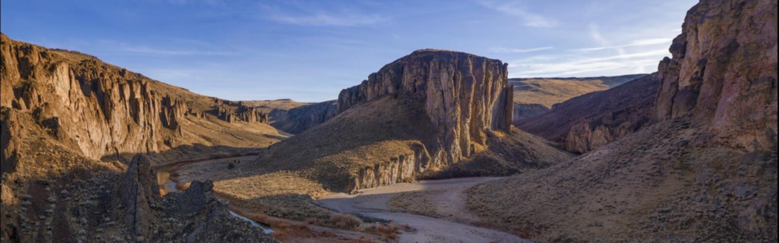
Ready to explore Ontario, Lake Owyhee, Vale Loop? Here's everything you need to know before you go!
Discover the trail
Oh no! We don't have any photos 😢
This trail hasn't been captured yet. Be the first to share your adventure!Trail description
The Ontario Lake Owyhee Vale Loop is a scenic hiking route in eastern Oregon that takes you through one of the most underrated landscapes in the Pacific Northwest. This area sits in the high desert of the Owyhee region, where the terrain opens up into wide canyon country, sagebrush flats, and the striking shores of Lake Owyhee — a reservoir formed by the Owyhee River that stretches deep into the rugged backcountry of Malheur County.
The town of Vale and the city of Ontario serve as the main gateways to this loop, making it accessible for hikers coming from the Treasure Valley area. The region doesn't get the same foot traffic as the Cascades or the coast, which is honestly part of the appeal — you're more likely to share the trail with a jackrabbit than another hiker.
The Landscape
The Owyhee country is high desert through and through. Expect wide-open skies, volcanic rock formations, rimrock cliffs, and the kind of silence that's hard to find closer to the city. Lake Owyhee itself is a dramatic feature — the water cuts through canyon walls that rise sharply on either side, and the color contrast between the blue-green reservoir and the rust-colored rock is genuinely striking.
The sagebrush steppe that surrounds much of this loop is classic eastern Oregon habitat. It looks sparse at first glance, but it supports a surprising variety of wildlife. Pronghorn antelope are commonly spotted in the open flats. Raptors — red-tailed hawks, prairie falcons, and golden eagles — are a regular sight overhead. Along the water and in the riparian corridors, you'll find a different ecosystem entirely, with cottonwoods, willows, and shorebirds that contrast sharply with the dry uplands just a short distance away.
What to Expect on the Trail
This is a loop route, which means you get a varied experience rather than retracing your steps. The terrain shifts as you move through different sections — from open desert walking to canyon edges to areas closer to the lake's shoreline. The volcanic geology of the Owyhee region means the ground underfoot can be rocky and uneven in places, so sturdy footwear is a good idea regardless of the season.
Navigation in this kind of open desert terrain requires some attention. Trails in the Owyhee region are not always heavily marked, and the landscape can look similar across large stretches. Bringing a map and knowing how to use it — or having an offline GPS track loaded — is genuinely useful here, not just a precaution for beginners.
Water is a critical consideration. The high desert environment means limited reliable water sources along the route, and temperatures in summer can be intense. Carrying more water than you think you'll need is standard practice for anyone hiking in this part of Oregon.
Best Times to Visit
Spring and fall are the sweet spots for hiking in the Owyhee region. Spring brings wildflowers to the desert floor and mild temperatures, while fall offers cooler air and the chance to see the landscape in different light. Summer is doable but demands early starts and serious heat management — midday temperatures in this part of eastern Oregon regularly climb well above what's comfortable for sustained hiking. Winter can bring snow and ice to the higher sections, and some access roads in the area may become impassable in wet conditions.
Access and Getting There
The loop is accessed from the Ontario and Vale area in Malheur County, eastern Oregon. Ontario sits along Interstate 84 near the Idaho border, making it a practical stopping point for travelers coming from Boise or Portland. Vale is a short drive from Ontario and sits closer to the Owyhee River drainage. Road conditions on the approach to Lake Owyhee State Park and the surrounding BLM lands can vary — gravel and dirt roads are common in this area, and a vehicle with reasonable clearance is helpful after wet weather.
Lake Owyhee State Park is the main managed area in this region and provides facilities including camping, boat launch access, and restrooms. Much of the surrounding land is managed by the Bureau of Land Management, which means access is generally open but infrastructure is minimal outside the state park boundaries.
Practical Notes
- Water: Carry all the water you need. Sources along the route are not reliable for drinking without treatment.
- Footwear: Rocky, uneven volcanic terrain makes sturdy hiking boots a better choice than trail runners for most hikers.
- Navigation: Trails in the Owyhee backcountry are not always well-signed. Download an offline map or GPS track before you go.
- Weather: Eastern Oregon weather can shift quickly. Check forecasts before heading out, especially in spring and fall when temperature swings are significant.
- Wildlife: This is rattlesnake country. Watch where you step and where you put your hands, particularly around rocky outcrops and in warm weather.
- Cell service: Expect limited to no cell coverage once you're away from the main highway. Let someone know your plans before you head out.
- Leave No Trace: The desert ecosystem here is fragile. Stay on established trails where they exist, pack out all waste, and avoid disturbing the biological soil crust that holds the desert floor together.
Why This Loop Stands Out
The Owyhee region is one of the least-visited corners of Oregon, and that's not because it lacks for scenery — it's simply off the radar for most hikers who default to the Cascades or the coast. The Ontario Lake Owyhee Vale Loop gives you a genuine taste of canyon country and high desert wilderness without the crowds. The combination of lake views, rimrock geology, open sagebrush flats, and diverse wildlife makes for a hiking experience that feels distinct from anything else in the state. If you're looking for solitude and a landscape that feels genuinely remote, this part of eastern Oregon delivers.
Everything you need for your next hike. Bilingual, printable, 1 page.
Get your free hiking checklistRecommended gear for this trail
As an Amazon Associate I earn from qualifying purchases.


Ready to go?
Everything you need to know before you goWhen?
As an Amazon Associate I earn from qualifying purchases.
Affiliate links — LGPO may earn a commission at no extra cost to you.
- Hiking shoes Essential
- → Salomon Elixir Tour Mid WP · 203.38 $
- Layered clothing Essential
- Rain jacket Essential
- Trekking poles
- → Black Diamond Trail Ergo Cork · 69.99 $
- Headlamp
- → Petzl Actik Core 625 · 103.95 $
FAQ - Frequently asked questions
Everything you need to knowOutings near Ontario, Lake Owyhee, Vale Loop
Discover other trails you might enjoy

Great River State Trail
Southwest Wisconsin · 1.4 km away

Central Ontario Loop Trail
Southwest Ontario · 13.7 km away
Kent Portage The Oldest Road in Ontario
31.9 km away
Eastern Ontario Bike Paths and Rail Trails
49.6 km away
Central Ontario Bike Paths and Rail Trails
59.8 km away
Paisley Trail
Southwest Ontario · 60.0 km away
Hiking near Sydney
25 trails to explore ~7556 km away
We work hard to provide the most up-to-date and error-free data possible. If something seems incorrect, let us know! Your contribution helps the whole community.
Hikers' opinions
Be the first to review!
No hiker has shared their experience yet. Share your impressions and help other hikers!