
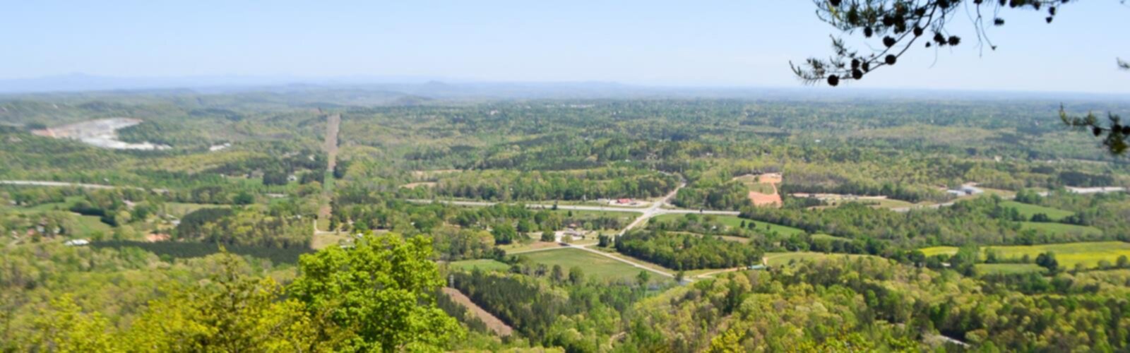

Ready to explore Currahee Mountain, Georgia? Here's everything you need to know before you go!
Discover the trail
Oh no! We don't have any photos 😢
This trail hasn't been captured yet. Be the first to share your adventure!Trail description
Currahee Mountain rises sharply from the rolling piedmont of northeast Georgia, making it one of the most recognizable landmarks in Stephens County. The name itself comes from the Cherokee word meaning "stands alone" — and once you see it, that name makes complete sense. The mountain sits in relative isolation, a solitary peak that dominates the surrounding landscape and draws hikers looking for a genuine climb with a rewarding payoff at the top.
A Mountain with History
Currahee Mountain carries a weight of history that sets it apart from most hiking destinations in Georgia. During World War II, the 506th Parachute Infantry Regiment of the 101st Airborne Division trained here at Camp Toccoa, running up and down the mountain as part of their grueling conditioning program. The phrase "Three miles up, three miles down" became a defining part of that regiment's identity — immortalized in Stephen Ambrose's book Band of Brothers and the HBO miniseries of the same name. For history buffs and veterans especially, hiking Currahee carries a meaning that goes well beyond the physical challenge.
The town of Toccoa sits at the base of the mountain, and the connection between the community and this peak runs deep. The Currahee Military Museum in Toccoa tells the full story of the 506th PIR if you want to dig into that history before or after your hike.
The Trail Experience
The trail to the summit of Currahee Mountain is a straightforward out-and-back route that follows the path those paratroopers once ran. It's not a technical hike, but don't let that fool you — the climb is consistent and the grade gets serious in sections, particularly as you approach the upper portion of the mountain. You're gaining real elevation in a relatively short horizontal distance, which means your legs will know they've worked by the time you reach the top.
The trail surface is a mix of dirt path and rocky sections. Footing is generally solid, but some areas can get slippery after rain, so trekking poles are a reasonable choice if you're planning a wet-weather visit. The route is well-worn and easy to follow — this is a popular local trail, and the path is clearly defined throughout.
As you climb, the forest transitions noticeably. Lower sections move through mixed hardwood forest typical of the Georgia piedmont, with oaks, hickories, and tulip poplars providing solid canopy cover. Higher up, the vegetation thins and the character of the trail shifts, giving you a sense of genuine ascent rather than just a walk in the woods.
Views from the Summit
The summit is the payoff, and it delivers. From the top of Currahee Mountain, you get sweeping views across the Georgia piedmont and into the Blue Ridge foothills to the north. On a clear day, the panorama is expansive — the kind of view that makes the climb feel completely worth it. There's a fire tower at the summit that has been a landmark here for decades, and it adds to the sense of arrival when you reach the top.
The summit area gives you space to rest, take in the views, and soak in the atmosphere before heading back down. The descent follows the same trail, and while it's faster than the climb, it demands attention — the steeper sections require controlled footing on the way down.
Practical Information
The trailhead is accessible from Toccoa, Georgia. Parking is available at the base of the mountain. The trail is open to the public and is a well-established part of the local outdoor scene — Toccoa residents use it regularly, and it draws visitors from across the region who come specifically for the historical connection and the views.
- Location: Toccoa, Stephens County, Georgia
- Trail type: Out-and-back
- Terrain: Dirt and rocky path, consistent climb with steeper sections near the summit
- Summit feature: Fire tower with panoramic views
- Historical significance: Training ground for the 506th PIR, 101st Airborne Division, WWII
What to Bring
Given the consistent elevation gain, solid footwear matters here — trail runners or hiking boots with decent grip are the right call. Bring enough water for the full round trip, since there are no water sources on the trail. A light layer is worth packing if you're hiking in cooler months, as the summit can be noticeably windier than the base. Sun protection is smart for the exposed upper sections and the open summit area.
Who This Hike Is For
Currahee Mountain works well for hikers who want a real workout without committing to a full-day backcountry adventure. The climb is challenging enough to feel satisfying but accessible enough that reasonably fit hikers of various experience levels can complete it. It's a popular choice for trail runners in the area, and the historical backstory makes it a meaningful destination for anyone with an interest in WWII history. Families with older kids who are comfortable on uneven terrain and sustained climbs will find it manageable, though younger children may find the grade demanding in sections.
If you're visiting Toccoa for any reason, Currahee Mountain is the kind of hike that earns its place on the itinerary — a genuine climb, a landmark summit, and a piece of American history all wrapped into one trail.
The Essential Hiking Checklist
Everything you need for your next hike. Bilingual, printable, 1 page.
Get your free hiking checklistRecommended gear for this trail
As an Amazon Associate I earn from qualifying purchases.


Ready to go?
Everything you need to know before you goWhen?
How much?
As an Amazon Associate I earn from qualifying purchases.
Affiliate links — LGPO may earn a commission at no extra cost to you.
- Hiking shoes Essential
- → Salomon Elixir Tour Mid WP · 203.38 $
- Layered clothing Essential
- Rain jacket Essential
- Trekking poles
- → Black Diamond Trail Ergo Cork · 69.99 $
- Headlamp
- → Petzl Actik Core 625 · 103.95 $
FAQ - Frequently asked questions
Everything you need to knowSimilar hikes nearby
Discover other trails you might enjoy


Hiking near Pittsburgh
0 trails to explore ~721 km away
We work hard to provide the most up-to-date and error-free data possible. If something seems incorrect, let us know! Your contribution helps the whole community.
Hikers' opinions
Be the first to review!
No hiker has shared their experience yet. Share your impressions and help other hikers!