

Ready to explore White Cap Mountain, Maine? Here's everything you need to know before you go!
Discover the trail
Trail description
Description
White Cap Mountain is one of Maine's most demanding backcountry peaks, and it earns that reputation honestly. Located in the remote interior of Piscataquis County within the Maine Highlands, this mountain sits at the center of an impressive cluster of summits — Hay Mountain to the east, Big Spruce Mountain to the south, and Little Spruce Mountain to the southeast. Together they form a rugged highland landscape that feels genuinely far from everything, because it is.
The full route covers 45.2 kilometers with 1,175 meters of elevation gain, and the estimated hiking time of 14 hours and 30 minutes reflects just how serious this undertaking is. This is rated very hard, and that rating is not conservative. You need solid fitness, good navigation skills, and the right gear before you set foot on this trail.
The Appalachian Trail Connection
One of the defining features of White Cap Mountain is its position along the Appalachian Trail. The AT doesn't just pass nearby — it traverses the mountain's four-mile ridge system and crosses directly over the summit. This means your time on the upper mountain isn't a quick push to a single high point and back down. Instead, you spend an extended stretch walking an elevated spine with multiple viewpoints, open terrain, and the kind of sustained exposure that makes this section one of the more memorable stretches of the AT in Maine.
Hikers who know the Appalachian Trail in this state understand that Maine's AT is a different beast from the trail further south. The terrain is rockier, the distances between access points are longer, and the weather can shift without much warning. White Cap fits squarely in that tradition.
What the Hike Actually Feels Like
The trail starts in dense mixed forest — spruce, fir, and hardwoods that are classic North Woods Maine. The early kilometers are about getting your legs under you and settling into the rhythm of a long day. The forest is thick and the canopy close, with the occasional sound of water from nearby drainages. It's a good warm-up, but don't let it lull you into a false sense of ease.
As elevation builds, the forest composition shifts and the terrain gets progressively more demanding. Rocky sections, rooted trail, and stretches of granite slab become more frequent. The approach to the ridgeline involves sustained climbing, and by the time you reach the main ridge, you've already put in real work. That's when the hike changes character entirely.
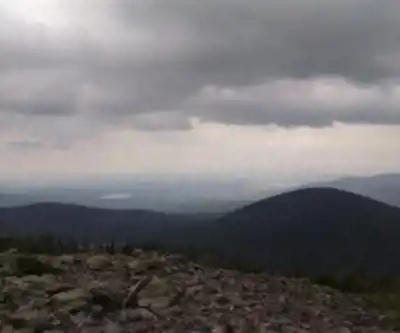
The ridge traverse is the payoff. The Appalachian Trail winds along the elevated spine, and the views open up across the Maine wilderness in a way that makes the effort feel worthwhile. The summit of White Cap Mountain delivers panoramic sightlines over the surrounding peaks and the vast forested landscape stretching in every direction. On a clear day, the scale of Maine's interior becomes genuinely apparent from up here.
Watershed and Natural Setting
White Cap Mountain sits within the Pleasant River watershed, part of the broader Penobscot River system that drains toward Penobscot Bay. The mountain's drainage patterns reflect its geography in interesting ways. The east-facing slopes send water into B Inlet Brook, which flows through B Pond before joining Guernsey Brook and eventually reaching the East Branch of the Pleasant River. The north and northwest slopes drain into the West Branch Ponds, feeding the West Branch of the Pleasant River, while the south side contributes to Greenwood Brook, another tributary of the same system.
This network of waterways creates a diverse mosaic of habitats throughout the area — streams, ponds, wetlands, and the forest ecosystems that connect them. Several small lakes dot the landscape around the mountain, adding to the wilderness character of the setting.
Trail Conditions and Terrain
Expect classic Maine mountain conditions: rocky, rooted, and unforgiving underfoot. Steep sections over granite slabs and through boulder fields are part of the deal, especially at higher elevations. Spring snowmelt and heavy rain can make the trail muddy and stream crossings more challenging, so timing and conditions matter. The trail is well-marked as part of the AT system, but the remote location means you're a long way from help if something goes wrong.
Weather on the exposed ridge can be significantly colder and windier than in the valleys below. Temperatures drop fast when clouds move in, and visibility on the ridge can deteriorate quickly. Layering appropriately and carrying rain gear isn't optional on a hike of this length and exposure.
Seasonal Notes
The main hiking season runs from late spring through fall. Spring conditions bring mud and unpredictable weather. Summer offers the longest daylight hours, which matters a great deal on a 14-plus-hour hike. Fall brings dramatic foliage across the surrounding forest, though conditions can turn wintry quickly as the season progresses. Winter travel on White Cap requires backcountry experience, appropriate equipment, and a realistic assessment of the added difficulty that snow, ice, and short daylight impose on an already demanding route.
Given the distance and the remoteness of the location, this hike is best suited to experienced hikers who are comfortable with long days in the backcountry and prepared for conditions to change. For those who fit that description, White Cap Mountain offers a genuine wilderness experience in one of Maine's most intact and impressive highland landscapes.
Recommended gear for this trail


Ready to go?
Everything you need to know before you goStarting Point
The trails at the white cap mountain, maine in Maine can be accessed from the summit of the mountain.
When?
How much?
- Hiking shoes Essential
- → Salomon Elixir Tour Mid WP · 203.38 $
- Layered clothing Essential
- Rain jacket Essential
- Trekking poles
- → Black Diamond Trail Ergo Cork · 69.99 $
- Headlamp
- → Petzl Actik Core 625 · 103.95 $
FAQ - Frequently asked questions
Everything you need to knowThe Essential Hiking Checklist
Everything you need for your next hike. Bilingual, printable, 1 page.
Download the free checklistSimilar hikes nearby
Discover other trails you might enjoy

Chimney Peak, Maine
Maine Highlands

Katahdin
Maine Highlands
Little Spencer Mountain
Maine Highlands
barnard mountain
Maine Highlands
Pleasant Pond Mountain
Maine Highlands
Katahdin Lake
Maine Highlands
Hiking near Sherbrooke
53 trails to explore ~86 km away
We work hard to provide the most up-to-date and error-free data possible. If something seems incorrect, let us know! Your contribution helps the whole community.
Hikers' opinions