PDF guide: Winter Hiking, the Method
FR EN
Let's Go Play Outside
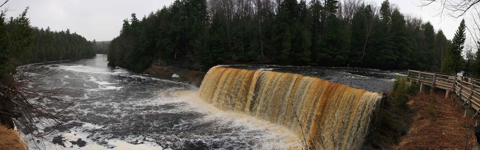
Hiking Tahquamenon Falls - panoramic view
--°C
Loading...
See forecast →

Hiking in the Tahquamenon Falls: trails, map and practical info

Eastern Upper Peninsula • Michigan

Photo: Bhasker Garudadri, CC BY-SA 3.0, via Wikimedia Commons

Tahquamenon Falls (Eastern Upper Peninsula, Michigan) : easy hike, 2.4 km, 30 m of elevation gain, about 0h36.

2.4 km
Distance
0h36
Duration
30 m
Elevation
Difficulty
Easy
Recommended for :
Beginners

Ready to explore Tahquamenon Falls? Here's everything you need to know before you go!

Discover the trail

Oh no! We don't have any photos 😢

This trail hasn't been captured yet. Be the first to share your adventure!

Trail description

The Tahquamenon Falls are two different waterfalls on the Tahquamenon River. Both sets are located near Lake Superior in the eastern Upper Peninsula of Michigan. The water is notably brown in color from the tannins leached from the cedar swamps which the river drains. The upper falls are more than 200 feet (60 m) across and with a drop of approximately 48 feet (14 m) During the late spring runoff, the river drains as much as 50,000 US gallons (190,000 L) of water per second, making the upper falls the third most voluminous vertical waterfall east of the Mississippi River, after Niagara Falls and Cohoes Falls, both in New York State. The lower falls, located four miles (6.5 km) downstream, are a series of five smaller falls cascading around an island which can be reached by rowboat. A hiking trail runs between the falls along the riverside, and visitors often play in the lower falls during the summer heat. The falls are within Tahquamenon Falls State Park, between Newberry, Michigan, and Paradise, Michigan. They are a popular tourist destination in the Upper Peninsula during all seasons. Snowmobile trails lead almost to the falls, and walkways are kept clear for most of the winter. The Tahquamenon is noted as being the land of Longfellow's The Song of Hiawatha - "by the rushing Tahquamenaw" where Hiawatha built his canoe. "Tahquamenon Falls" is also a song from Sufjan Stevens's album Michigan. While the name Tahquamenon is now primarily associated with the falls, it appears to have originally designated an island in Whitefish Bay: Tahquamenon Island. The first written record of the name appears as "Outakouaminan" in a 1671 French map.[1] The upper falls are located at 46°34′29″N 85°15′23″W and the lower falls are at 46°36′12″N 85°12′25″W
Free 1 page
The Essential Hiking Checklist

Everything you need for your next hike. Bilingual, printable, 1 page.

Get your free hiking checklist

Recommended gear for this trail

Affiliate links — LGPO may earn a commission at no extra cost to you. Disclosure
As an Amazon Associate I earn from qualifying purchases.

LGPO Pick
Elixir Tour Mid WP
Salomon
Elixir Tour Mid WP
Waterproof mid-height boot ideal for rocky terrain
See price
Daylite Plus 20L
Osprey
Daylite Plus 20L
Lightweight and versatile for day hikes
See price
Wide Mouth 1L
Nalgene
Wide Mouth 1L
Unbreakable and BPA-free — a hiking essential
See price
Best Value
Trail Ergo Cork
Black Diamond
Trail Ergo Cork
Comfortable cork grip for long ascents
See price
Actik Core 625
Petzl
Actik Core 625
USB rechargeable with 600 lumens for early starts
See price

Ready to go?

Everything you need to know before you go

Where?

Address
Not available
GPS coordinates
46.5781, -85.2068649
Phone
Not available

When?

Opening hours
No information
Weather (next days)
Loading
What to bring?

Affiliate links — LGPO may earn a commission at no extra cost to you. Disclosure
As an Amazon Associate I earn from qualifying purchases.

General hiking tips, to adapt to your outing.
Gear
Download the PDF checklist
Water & food
Tip: bring water
Good to know
In an emergency
Emergency
911
GPS coordinates
46.5781, -85.2068649

Hikers' opinions

Be the first to review!

No hiker has shared their experience yet. Share your impressions and help other hikers!

FAQ - Frequently asked questions

Everything you need to know
Tahquamenon Falls is rated easy.
The elevation gain of Tahquamenon Falls is 30 m.
Allow about 0h36 for Tahquamenon Falls (2.4 km).
Didn't find your answer?
Top 10 best hiking in Eastern Upper Peninsula
Our ranking based on hiker reviews

Hiking near Barrie

145 trails to explore ~495 km away

View trails near Barrie
Did you spot an error?

We work hard to provide the most up-to-date and error-free data possible. If something seems incorrect, let us know!

Update : November 2026