

Ready to explore Bondcliffs, New Hampshire? Here's everything you need to know before you go!
Discover the trail
Trail description
Description
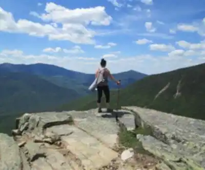
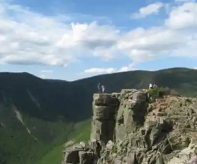
Bondcliffs is one of those hikes that earns its reputation. Located deep in the Pemigewasset Wilderness of the White Mountains, this is a long, committing day out — 17.7 km with 1,067 m of elevation gain and a realistic time commitment of around 6.5 hours. It's rated hard, and that rating is honest. But for hikers who are ready for it, the payoff is a dramatic open ridgeline with some of the best views in all of New Hampshire.
What Makes Bondcliffs Stand Out
The defining feature of this hike is the cliff-edge ridgeline that gives it its name. Once you reach the top, you're walking along an exposed rocky spine with sweeping views in every direction — the Pemigewasset Wilderness stretching out below, the Franconia Ridge to the west, and the Bond range continuing to the north. It's the kind of terrain that feels genuinely remote, because it is. You're well inside the wilderness boundary by the time you get there, and the crowds thin out considerably compared to more accessible White Mountain summits.
The approach itself is part of the experience. The trail follows the Lincoln Brook corridor for a significant stretch before climbing, which means you're moving through dense boreal forest, crossing streams, and gradually gaining elevation before the terrain opens up. It's not a hike where the reward comes quickly — you earn the views over several hours of steady effort.
The Terrain
Expect a mix of terrain throughout the day. The lower sections follow well-worn forest trail with some rooty and rocky stretches typical of White Mountain hiking. As you gain elevation, the trail steepens and the footing becomes more technical — loose rock, exposed roots, and sections that require hands-on scrambling in places. The upper ridgeline is open and rocky, which is spectacular in good conditions but can be slippery and exposed in wet or windy weather.
Stream crossings are part of the route, and depending on the season and recent rainfall, water levels can vary significantly. Early season crossings can be challenging. Trekking poles are genuinely useful here, both for the stream crossings and for managing the descent on tired legs after a long day.
Difficulty and Fitness Level
This hike is best suited to experienced hikers who are comfortable with long days in the backcountry. The combination of distance, elevation gain, and remote location means that if something goes wrong — a twisted ankle, a sudden weather change — you're a long way from the trailhead. That's not a reason to avoid it, but it is a reason to go prepared.
Strong intermediate hikers who have completed other hard-rated White Mountain trails will find this challenging but manageable. First-time White Mountain hikers or those who haven't done significant elevation gain recently should build up to this one.
Planning Your Day
With an estimated 6.5 hours on trail, an early start is strongly recommended. The White Mountains are known for afternoon thunderstorms, especially in summer, and being on an exposed ridgeline when weather rolls in is not where you want to be. Aim to be on the summit or past the exposed sections before early afternoon.
- Distance: 17.7 km
- Elevation gain: 1,067 m
- Estimated time: 6.5 hours
- Difficulty: Hard
Carry more water than you think you need. The approach is long and the climbing is sustained — dehydration sneaks up on people on this kind of route. A water filter or purification tablets are worth bringing given the stream access along the way.
The Pemigewasset Wilderness Context
Bondcliffs sits within the Pemigewasset Wilderness, a federally designated wilderness area managed by the White Mountain National Forest. This designation means no motorized or mechanized equipment, and the trails are maintained to a wilderness standard — which in practice means less infrastructure and more raw trail than you'd find on some of the more developed White Mountain routes. That's part of the appeal. The wilderness designation also means group size limits apply, so if you're going with a larger group, check current regulations before heading out.
The area has a rich history tied to the logging era of the late 19th and early 20th centuries, when much of this forest was heavily cut. The recovery of the forest since then is remarkable, and hiking through it today gives little indication of how dramatically the landscape was altered a century ago.
What to Bring
The White Mountains have a well-deserved reputation for fast-changing weather, and Bondcliffs is no exception. Even on a clear summer day, conditions on the exposed ridgeline can be significantly different from the trailhead. Pack layers, a rain shell, and don't rely solely on a weather forecast from the morning.
- Sturdy hiking boots with good ankle support
- Trekking poles (highly recommended)
- Rain gear and an extra layer
- Plenty of food and water
- Map and compass or downloaded offline map — cell service is unreliable in the wilderness
- Headlamp in case your day runs long
Getting There
The most common approach to Bondcliffs starts from the Lincoln Woods trailhead off the Kancamagus Highway (Route 112) in Lincoln, New Hampshire. A White Mountain National Forest parking pass is required at this trailhead. The Lincoln Woods trailhead is a busy starting point for multiple wilderness routes, so arriving early also helps with parking.
From the trailhead, the route follows the Wilderness Trail before branching onto the Bondcliff Trail for the climb to the ridgeline. Trail signage in the White Mountain National Forest is generally reliable, but carrying a map of the Pemi Wilderness is still good practice given the network of intersecting trails in the area.
Recommended gear for this trail


Ready to go?
Everything you need to know before you goStarting Point
To access the hiking trails, you can start at the Lincoln Woods Trailhead. The parking lot is located on the Kancamagus Highway (Route 112), approximately 5 miles east of Lincoln, NH. The address for GPS navigation is 112 Kancamagus Hwy, Lincoln, NH 03251.
When?
How much?
- Hiking shoes Essential
- → Salomon Elixir Tour Mid WP · 203.38 $
- Layered clothing Essential
- Rain jacket Essential
- Trekking poles
- → Black Diamond Trail Ergo Cork · 69.99 $
- Headlamp
- → Petzl Actik Core 625 · 103.95 $
FAQ - Frequently asked questions
Everything you need to knowThe Essential Hiking Checklist
Everything you need for your next hike. Bilingual, printable, 1 page.
Download the free checklistSimilar hikes nearby
Discover other trails you might enjoy

Crawford
White Mountains
Welch-Dickey Trailhead
White Mountains
White Mountain National Forest
White Mountains
Presidential Range Rail Trail
White Mountains
Sabbaday Falls
White Mountains
Swift River
White Mountains
Hiking near North Conway
0 trails to explore ~34 km away
We work hard to provide the most up-to-date and error-free data possible. If something seems incorrect, let us know! Your contribution helps the whole community.
Hikers' opinions