

Ready to explore Mount Adams, New Hampshire? Here's everything you need to know before you go!
Discover the trail
Trail description
Description
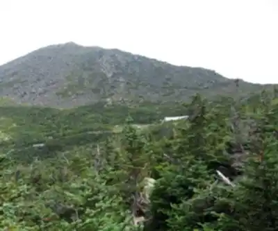
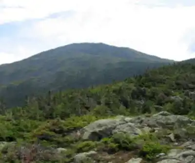
Mount Adams stands as New Hampshire's second-highest peak at 5,774 feet, offering one of the most challenging and rewarding hikes in the White Mountains. Named after America's second president, John Adams, this formidable mountain attracts experienced hikers seeking a serious physical test paired with spectacular alpine views. The standard route via Air Line Trail is notorious for its relentless steepness and technical rock scrambles, making it a rite of passage for White Mountain enthusiasts.
What sets Mount Adams apart from other presidential peaks is its wild, exposed character. Unlike the more developed Mount Washington, Adams maintains a raw alpine environment where hikers face genuine mountain conditions. The summit cone rises dramatically above treeline, creating an imposing profile visible from throughout the region. Weather can change rapidly at this elevation, and the exposed ridges offer little protection from wind and storms.
The Trail Experience
Your adventure begins at the Appalachia parking area, where multiple trail signs point toward various routes up the northern presidentials. Follow the signs for Air Line Trail, which wastes no time in announcing its intentions. The trail immediately begins climbing at a punishing grade that rarely lets up for the next several miles.
The initial forest section provides some relief from what's to come, winding through dense spruce and fir. But as you gain elevation, the trail becomes increasingly steep and rocky. The first major landmark comes as you approach the ridge, where stunning views open up toward King Ravine—a dramatic glacial cirque that showcases the raw geological forces that shaped these mountains.
The real challenge begins as you push above treeline. Here, Air Line Trail lives up to its reputation as one of the steepest maintained trails in the White Mountains. You'll encounter extensive rock fields that require careful navigation, especially during wet conditions when the granite becomes slippery and potentially dangerous. These boulder scrambles demand both physical strength and mental focus, as a misstep could result in serious injury.
The exposed ridge section offers breathtaking but demanding hiking. Strong winds are common, and weather protection becomes essential. As you approach the summit, the views expand dramatically. To the south, Mount Washington dominates the skyline, while Jefferson and Madison complete the presidential ridge. Looking east, the Carter Range stretches toward the horizon, with Mount Wildcat ski area visible in the distance.
The summit itself provides a 360-degree panorama that justifies every challenging step. On clear days, you can see deep into Vermont's Green Mountains to the west and catch glimpses of Maine's peaks to the east. The sense of accomplishment here is profound—you've conquered one of New England's most demanding day hikes.
The Descent Route
For safety reasons, avoid descending the steep Air Line Trail. Instead, continue from the summit following Air Line Trail briefly until you reach the intersection with Gulfside Trail. Turn right toward Madison Spring Hut, a welcome sight that marks your transition to easier terrain.
From Madison Spring Hut, take Valley Way Trail on your left for the descent back to Appalachia. This route, while longer, provides much safer footing and a more gradual descent through beautiful forest sections. Valley Way offers a completely different perspective on the mountain, passing through varied ecosystems as you descend from alpine zone back to northern hardwood forest.
The descent route includes multiple trail intersections, making navigation more complex than the straightforward ascent. A topographic map and compass are essential gear for this hike, as weather can reduce visibility quickly above treeline. Pay careful attention to trail blazes and signs, particularly in the upper sections where trails can be less obvious.
Planning Your Hike
This loop covers approximately 12 kilometers with 1,766 meters of elevation gain, requiring 6 to 8 hours for most hikers. The physical demands cannot be overstated—this ranks among the most strenuous day hikes in the Northeast. Proper conditioning is essential, as the steep grades and technical terrain will test your limits.
The Appalachia parking area provides free parking, though spaces fill quickly during peak season and on weekends. Arrive early, especially during fall foliage season when the White Mountains see heavy visitation. The lot serves multiple popular trails, so competition for spaces is fierce.
Weather considerations are critical for Mount Adams. The exposed summit and ridges create dangerous conditions during storms, high winds, or low visibility. Check forecasts carefully and be prepared to turn back if conditions deteriorate. Lightning poses a serious threat on the exposed upper sections, and hypothermia remains a risk even during summer months.
What to Expect
Mount Adams demands respect and preparation. The trail's reputation for difficulty is well-earned, with sections that will challenge even experienced hikers. Rock scrambles require good upper body strength and confidence on steep terrain. The sustained steep grades test cardiovascular fitness and leg strength throughout the ascent.
Dogs are welcome on leash, though owners should carefully consider their pet's fitness level and ability to handle steep rock sections. The technical terrain and long distance make this unsuitable for most dogs, and the exposed conditions can be dangerous for animals unprepared for alpine environments.
The trails remain open year-round, but winter conditions transform this into a serious mountaineering objective requiring specialized equipment and experience. Summer and early fall provide the most reasonable conditions for hiking, though even then, proper gear and preparation remain essential for a safe and enjoyable experience on this magnificent but demanding peak.
Recommended gear for this trail


Ready to go?
Everything you need to know before you goStarting Point
To access the hiking trails, you can start at several trailheads. One option is the Appalachia Trailhead, located on U.S. Route 2 in Randolph, NH. Another starting point is the Lowe's Path Trailhead, which can be found at Lowe's Store on Route 2 in Randolph, NH. Both locations provide parking facilities for hikers.
When?
How much?
- Hiking shoes Essential
- → Salomon Elixir Tour Mid WP · 203.38 $
- Layered clothing Essential
- Rain jacket Essential
- Trekking poles
- → Black Diamond Trail Ergo Cork · 69.99 $
- Headlamp
- → Petzl Actik Core 625 · 103.95 $
FAQ - Frequently asked questions
Everything you need to knowThe Essential Hiking Checklist
Everything you need for your next hike. Bilingual, printable, 1 page.
Download the free checklistSimilar hikes nearby
Discover other trails you might enjoy

Crawford
White Mountains
White Mountain National Forest
White Mountains
Presidential Range Rail Trail
White Mountains
Welch-Dickey Trailhead
White Mountains
Sabbaday Falls
White Mountains
Swift River
White Mountains
Hiking near North Conway
0 trails to explore ~32 km away
We work hard to provide the most up-to-date and error-free data possible. If something seems incorrect, let us know! Your contribution helps the whole community.
Hikers' opinions