

Ready to explore Mount Eisenhower, New Hampshire? Here's everything you need to know before you go!
Discover the trail
Trail description
Description
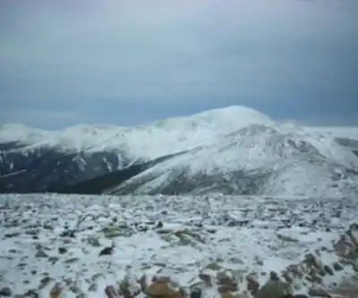
Mount Eisenhower is one of the most satisfying peaks in New Hampshire's Presidential Range — and one of the few where the summit actually delivers on its promise. At 4,760 feet, the mountain's open, dome-shaped top gives you a full 360-degree panorama with nothing blocking the view in any direction. Originally called Mount Pleasant, it was renamed to honor President Dwight D. Eisenhower, and it's since become a go-to destination for peak-baggers working through New Hampshire's 48 four-thousand footers as well as day hikers who want a genuine alpine experience without committing to a full Presidential traverse.
What makes Eisenhower stand out among its Presidential neighbors is that exposed summit dome. A lot of peaks in this range keep you guessing until the very last steps — not here. You break out of the trees well below the top, and the views open up progressively as you climb the final stretch of open rock. By the time you're standing on the summit slabs, you've got the entire Presidential Range laid out in front of you, with Mount Monroe and the hulking mass of Mount Washington to the northeast, Mount Pierce to the southwest, and ridge after ridge of New Hampshire high country filling every other direction.
Trail Routes and Access
Two main routes lead to the summit, both starting from parking areas on Mount Clinton Road. The Edmands Path departs from a lot to the west-northwest of the peak and is generally considered the most direct approach. It's well-maintained throughout, climbing steadily through mixed northern forest before the trees thin out and the upper slopes open up. Most hikers heading specifically for Eisenhower's summit choose this route.
The second option is the Crawford Path, which is also the route of the Appalachian Trail through this section of the Presidentials. The trailhead sits on Mount Clinton Road very close to Route 302, just north of the Highland Center in Crawford Notch. If you've ever wanted to walk a stretch of America's most famous long-distance trail, this is a solid opportunity to do it on a day hike.
One thing worth knowing about the Crawford Path: it doesn't go directly over Eisenhower's summit. At around 4,400 feet — roughly 0.3 miles south of the top — the main trail splits off onto a bypass that skirts the high point, topping out at about 4,520 feet before rejoining the summit loop 0.3 miles to the northeast. If you're following the AT and want to actually tag the summit, you'll need to take the short detour. It's worth it.
The Highland Center near the Crawford Path trailhead is a useful resource before or after your hike, offering information and facilities in a convenient location relative to the trailhead.
What to Expect on the Trail
The round trip covers 10.5 kilometers with 762 meters of elevation gain, and most hikers should budget around 6 hours for the full outing. The difficulty is rated hard — the elevation gain is sustained, and the exposed upper mountain adds a layer of commitment that lighter trails don't have.
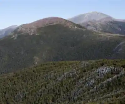
The lower sections of both routes move through the dense northern hardwood and coniferous forest that defines the White Mountains at mid-elevation. As you gain height, the trees get shorter and more gnarled — classic krummholz territory — before giving way entirely to alpine vegetation and open rock on the upper cone. That transition from closed forest to open ridge is one of the more satisfying moments on any Presidential hike, and Eisenhower delivers it earlier than most.
The summit itself is a broad expanse of rock slabs and low alpine growth. It feels genuinely remote up there, even on a busy weekend, because the terrain demands your full attention and the scale of the surrounding landscape puts everything in perspective. On a clear day you can trace the entire Presidential ridge, pick out the summit cone of Mount Washington, and watch weather systems moving across the valleys far below.
That exposure is also the main thing to plan around. The summit has zero wind protection, and conditions can shift fast. Even on a warm summer day, temperatures at 4,760 feet can be significantly cooler than at the trailhead, and afternoon thunderstorms are a real consideration in the warmer months. Bring layers, rain gear, and don't count on the forecast holding all day.
Peak-Bagging Context
Eisenhower sits on the official New Hampshire four-thousand footer list, which makes it a required summit for anyone working toward completing all 48. Its position on the Presidential ridge also makes it a natural candidate for combination days. Mount Pierce to the southwest and Mount Monroe to the northeast are both within reasonable range for strong hikers looking to link peaks. Between Eisenhower and Monroe lies Mount Franklin, an unofficial summit that doesn't qualify for the four-thousand footer list due to insufficient prominence, but still offers good views and serves as a natural waypoint on the ridge traverse.
The mountain is only accessible on foot — there's no road to the top — which keeps the summit feeling earned regardless of how busy the trailhead gets. That's part of what makes the Presidential Range worth the effort, and Eisenhower is one of the better entry points into it.
Recommended gear for this trail


Ready to go?
Everything you need to know before you goStarting Point
To access the hiking trails, you can start at the Crawford Path trailhead. The parking lot is located at the AMC Highland Center, 6 AMC Highland Center Road, Bretton Woods, NH 03575. Another option is to begin at the Edmands Path trailhead, with parking available on Mount Clinton Road off Route 302.
When?
How much?
- Hiking shoes Essential
- → Salomon Elixir Tour Mid WP · 203.38 $
- Layered clothing Essential
- Rain jacket Essential
- Trekking poles
- → Black Diamond Trail Ergo Cork · 69.99 $
- Headlamp
- → Petzl Actik Core 625 · 103.95 $
FAQ - Frequently asked questions
Everything you need to knowThe Essential Hiking Checklist
Everything you need for your next hike. Bilingual, printable, 1 page.
Download the free checklistSimilar hikes nearby
Discover other trails you might enjoy

Crawford
White Mountains
Presidential Range Rail Trail
White Mountains
Welch-Dickey Trailhead
White Mountains
Sabbaday Falls
White Mountains
Swift River
White Mountains
Mt Bond
White Mountains
Hiking near North Conway
0 trails to explore ~27 km away
We work hard to provide the most up-to-date and error-free data possible. If something seems incorrect, let us know! Your contribution helps the whole community.
Hikers' opinions