

Ready to explore Mount Jefferson, New Hampshire? Here's everything you need to know before you go!
Discover the trail
Trail description
Description
Mount Jefferson stands as the third-highest peak in New Hampshire's Presidential Range at 1,741 meters, offering one of the most challenging and rewarding hiking experiences in the White Mountains. Named after America's third president, Thomas Jefferson, this imposing mountain delivers steep, technical terrain that demands respect and proper preparation. The summit rewards those who make the climb with sweeping panoramic views of neighboring peaks Mount Washington and Adams, along with the rugged landscape that defines this iconic mountain range.
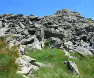
What sets Mount Jefferson apart from other Presidential Range peaks is its notably rocky and exposed character. The mountain's upper reaches feature extensive areas of bare granite and challenging scrambles that require hikers to use their hands as much as their feet. This technical terrain, combined with the peak's exposure to rapidly changing weather conditions, creates an alpine environment that feels more remote and wild than many other New Hampshire summits of similar elevation.
The Caps Ridge Trail Approach
The most direct route to Mount Jefferson's summit begins at the parking area on Jefferson Notch Road and follows the Caps Ridge Trail. This 8-kilometer round-trip hike involves 825 meters of elevation gain and typically requires about 5 hours to complete. While it's the shortest path to the top, the Caps Ridge Trail is also one of the most technically demanding routes in the Presidential Range.
The trail's defining characteristic is its series of rocky caps—exposed granite outcroppings that require careful scrambling. These sections transform the hike from a simple walk in the woods into a genuine mountaineering experience. Hikers will find themselves navigating steep rock faces where handholds become more important than trekking poles. The granite can become treacherously slippery when wet, making this route particularly hazardous during rainy or windy conditions.
As you ascend, the forest gradually gives way to increasingly exposed terrain. The upper portions of the trail offer little protection from wind and weather, and temperatures can drop dramatically with elevation gain and wind exposure. The final approach to the summit involves navigating through a landscape of weathered granite and hardy alpine vegetation, where the trail becomes less defined and route-finding skills prove valuable.
Summit Experience and Views
Mount Jefferson's summit presents a stark, beautiful landscape of exposed rock and 360-degree views across the White Mountains. The peak's rugged character is immediately apparent—this isn't a gentle, forested mountaintop but rather an alpine environment that showcases the raw power of New England's mountain weather. On clear days, the views extend across the Presidential Range, with Mount Washington's distinctive profile dominating the southern horizon and Mount Adams rising prominently to the northeast.
The summit area itself requires careful navigation, as the actual high point sits among a collection of rocky outcroppings. The exposed nature of the peak means weather conditions can change rapidly, and what begins as a pleasant hiking day can quickly turn challenging as clouds move in and winds pick up. This dramatic weather variability is part of what makes Mount Jefferson such a compelling destination for experienced hikers seeking a true mountain experience.
Seasonal Access and Planning
While the trails on Mount Jefferson remain open year-round, access via Jefferson Notch Road is seasonal. The road closes from November through May, requiring winter hikers to choose alternative, longer approaches during the colder months. This seasonal closure significantly increases the difficulty and commitment required for winter ascents, making Mount Jefferson primarily a spring-through-fall destination for most hikers.
During the accessible months, hikers should still prepare for alpine conditions regardless of the season. The mountain's elevation and exposure mean that weather on the summit can be dramatically different from conditions at the trailhead. Proper layering systems, wind protection, and emergency gear are essential, even on seemingly pleasant days.
Practical Information
Parking at the Jefferson Notch Road trailhead requires a fee, which can be paid on-site or through the purchase of a parking sticker. These stickers are available at the AMC Visitor Centers at Crawford Notch on Route 302 and Pinkham Notch on Route 16. The parking area serves multiple trails, so arriving early during peak hiking seasons is advisable to secure a spot.
Dogs are welcome on Mount Jefferson's trails but must remain on leash throughout the hike. Given the technical nature of the Caps Ridge Trail's scrambling sections, hikers should carefully consider their pet's climbing abilities and comfort level with exposed terrain before bringing them along.
The technical demands of the Caps Ridge Trail make proper equipment essential. Sturdy hiking boots with good traction are crucial for the rocky scrambles, and many hikers find gloves helpful for the extensive hand-over-hand climbing sections. Trekking poles, while useful for the initial forest sections, become less practical and may need to be stowed during the technical scrambling portions of the route.
Recommended gear for this trail


Ready to go?
Everything you need to know before you goStarting Point
To access the hiking trails, you can start at several trailheads:
Caps Ridge Trailhead: Located on Jefferson Notch Road. This is a popular starting point due to its high elevation and shorter distance to the summit.
Castle Trailhead: Found off Route 2, near Bowman, NH. This trail offers a more challenging ascent with scenic views.
Jewell Trailhead: Accessible from the Base Station Road parking area, which also serves the Cog Railway. This trail provides a longer but gradual climb.
Ensure to check road conditions and accessibility, especially during winter months, as some roads may be closed or require four-wheel drive vehicles.
When?
How much?
- Hiking shoes Essential
- → Salomon Elixir Tour Mid WP · 203.38 $
- Layered clothing Essential
- Rain jacket Essential
- Trekking poles
- → Black Diamond Trail Ergo Cork · 69.99 $
- Headlamp
- → Petzl Actik Core 625 · 103.95 $
FAQ - Frequently asked questions
Everything you need to knowThe Essential Hiking Checklist
Everything you need for your next hike. Bilingual, printable, 1 page.
Download the free checklistSimilar hikes nearby
Discover other trails you might enjoy

Crawford
White Mountains
White Mountain National Forest
White Mountains
Presidential Range Rail Trail
White Mountains
Welch-Dickey Trailhead
White Mountains
Sabbaday Falls
White Mountains
Swift River
White Mountains
Hiking near North Conway
0 trails to explore ~32 km away
We work hard to provide the most up-to-date and error-free data possible. If something seems incorrect, let us know! Your contribution helps the whole community.
Hikers' opinions