Hiking Mount Lafayette, New Hampshire - panoramic view
--°C
Loading...
See forecast →

Hiking in Mount Lafayette, New Hampshire: trails, map and practical info

White Mountains • New Hampshire

4.8 Appreciated by 50 hikers
François Dumaine
By François DumaineContributor since 2015Updated 03/04/2026
Difficulty
Very hard
Distance
13 km
Elevation
1,600 m
Duration
6h30
Max altitude
1,603 m

A very hard 12.87 km trek through New Hampshire's White Mountains, conquering three 4,000-foot peaks including Mount Lafayette — the highest summit outside the Presidential Range. This 6 to 8-hour adventure features an exposed knife-edge ridge traverse with unmatched New England views.

Recommended for :
Intermediate hikers

Ready to explore Mount Lafayette, New Hampshire? Here's everything you need to know before you go!

Discover the trail

6 community photos

Available trails

Trails Distance Elevation Duration Difficulty GPX
129 km 1124 m 30h30 Advanced GPX
118 km 1124 m 28h Advanced GPX
Click a trail to see it on the map

Trail description

Description

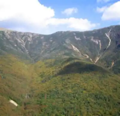
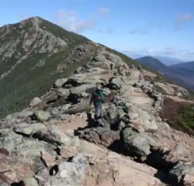
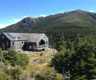
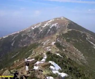
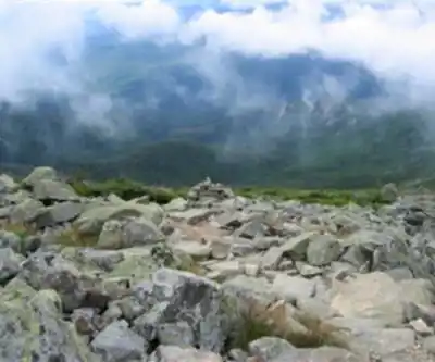
The Mount Lafayette loop via Falling Waters and Old Bridle Path ranks among New England's most spectacular day hikes, combining three 4,000-foot summits with the famous knife-edge traverse of Franconia Ridge. This 12.87-kilometer loop gains 1,600 meters of elevation over 6 to 8 hours, making it a very hard but incredibly rewarding challenge that's best tackled from April through October.

Mount Lafayette stands as the highest peak outside New Hampshire's Presidential Range at 5,242 feet, and the fourth most prominent peak in New England according to the New England Fifty Finest List. The loop takes you over three peaks—Little Haystack, Lincoln, and Lafayette—with the highlight being the exposed 2-mile ridge walk that connects them. On clear days, you'll have stunning views of Mount Washington and the Presidential Range to the east, and you can even spot peaks in the Adirondacks.

Getting There and Parking

The trailhead is located right off I-93 at the southern end of Franconia Notch State Park. Take exit 34B for Lafayette Place Campground Trail Head Parking. Parking costs $3 per day, but spaces are limited and the trail gets busy on weekends and holidays, so arrive early. If the main lot is full, you can park on either side of I-93 since there's a foot tunnel connecting both sides, or across the highway at Lafayette Campground. Restrooms are located right after the trailhead.

The Falling Waters Trail Ascent

Most hikers start with the Falling Waters Trail, which climbs fairly quickly and rewards you with several beautiful waterfalls along the way. This trail is part of the Appalachian Trail and provides the more direct but steeper route to the ridge. The path is quite steep and rocky, but the waterfalls and relatively fast elevation gain make it rewarding. After 3 miles of steady climbing, you'll break out of the treeline and reach the summit of Little Haystack Mountain, where the real adventure begins.

Franconia Ridge Traverse

From Little Haystack, turn left onto the Franconia Ridge Trail for one of the most spectacular ridge walks in the Northeast. This exposed 2-mile knife-edge traverse connects Little Haystack to Mount Lincoln (0.7 miles) and then to Mount Lafayette (another 1.3 miles). The ridge is completely above treeline, offering 360-degree views but also full exposure to weather. Check conditions carefully before committing to this section—75 mph winds and whiteout conditions can turn this beautiful walk into a dangerous situation, as evidenced by past accidents on the ridge.

The traverse involves some strenuous and nerve-wracking hiking, especially in poor weather. You'll gain and lose elevation as you cross each summit, with Mount Lincoln marking the midpoint of the ridge walk. The rocky terrain can be challenging, particularly when wet or icy.

Mount Lafayette Summit

After climbing 3,800 feet over approximately 5 miles, you'll reach Mount Lafayette's summit, the highest point of the day and the sixth highest peak on New Hampshire's 4,000-footer list. On clear days, the views are wonderful in all directions. If weather turns bad or winds pick up, you can take shelter behind the old stone walls on the west side of the summit before beginning your descent.

Descent via Old Bridle Path

The return route follows the Old Bridle Path, which provides a more gradual descent and different scenery. About a mile down from Lafayette's summit, you'll reach the AMC Greenleaf Hut and Eagle Lake. This hut is notably clean and well-maintained compared to other AT huts in New Hampshire, and offers water, restrooms, and a place to rest. The first mile of the Bridle Path from the hut is relatively easy with little elevation change, but after that, you'll descend through tree-covered terrain that becomes increasingly steep and rocky, which can be stressful on the knees.

What to Bring

This is a long and strenuous hike requiring plenty of preparation. Bring ample food and water—some hikers carry a gallon plus additional bottles for the full loop. Pack a warm top layer as temperatures drop significantly on the exposed ridge, even in summer. The rocky terrain is tough on feet, so sturdy hiking boots are essential. If bringing dogs, consider paw protection like wax or booties since the rocks can be hard on their pads.

Family Considerations

While challenging, this hike has been completed by families with young children using hiking carriers. Some hikers have successfully brought 3 and 6-year-olds, though this requires careful planning and strong adults willing to carry extra weight. The rocky terrain and exposure make this unsuitable for inexperienced young hikers walking on their own.

Alternative Routes

Besides the popular Falling Waters/Old Bridle Path loop, alternative approaches include the Skookumchuck Trail and Walker Brook Ravine. Some hikers prefer ascending via the Old Bridle Path and descending Falling Waters to tackle the steeper sections while fresh, though the standard loop direction is more common.

Seasonal Considerations

While this peak can be climbed year-round, winter conditions require mountaineering experience and equipment. The exposed ridge becomes particularly dangerous in winter weather. Summer months see heavy crowds, especially weekends and holidays. Spring and fall offer the best combination of good weather and fewer crowds, though weather can change rapidly any time of year.

Camping Options

For those wanting to extend the adventure, several camping options exist in the area. The AMC runs Liberty Springs Tentsite to the south and Garfield Ridge Tentsite to the north, both offering wooden tent platforms, springs, and composting toilets for a fee. These sites operate on a first-come, first-served basis and fill up quickly on summer weekends. The Greenleaf Hut area is also popular for winter camping when the hut itself is closed. Dogs are welcome on all trails in this area.

Ready to go?

Everything you need to know before you go

Where?

Address
Mount Lafayette, Franconia, NH 03251, USA
GPS coordinates
44.16066199999999, -71.6445066
Phone
Not available

Starting Point

To access the hiking trails, you can start at the main trailhead located at the Lafayette Place Campground. The address is Franconia Notch State Park, I-93 Exit 34B, Lincoln, NH 03251. There is a parking lot available for hikers. Another option is to begin at the Falling Waters Trailhead, which shares the same parking area as the Old Bridle Path Trailhead at Lafayette Place.

When?

Opening hours
Varies by season
Best season
Fall
Spectacular colors
Best time
Early morning
Less crowded
Weather (next days)
Loading

How much?

Entry fees
Adult
Not available
Child
What to bring?
Gear
  • Hiking shoes Essential
  • Layered clothing Essential
  • Rain jacket Essential
  • Trekking poles
  • Headlamp
Download the PDF checklist
Water & food
2L minimum
No water point on the trail
Bring energy snacks for a 4h+ hike
Good to know
Park rules
No dogs
Safety
Download the GPX before you go
Limited cellular coverage on the trail
Slippery after rain
Be careful on rocky sections
In an emergency
Emergency
911
Parking GPS
44.16066199999999, -71.6445066
Center
Not available

Hikers' opinions

4.8
30 Reviews
R1
Review 10
Mar 25, 2024
Beautiful White Mountains scenery throughout this challenging hike. Mount Lafayette's 1600m ascent over 12.87km showcases New Hampshire's stunning wilderness at its finest. The demanding trail rewards hikers with spectacular summit views, making this very hard but beautiful hiking experience truly memorable.
R9
Review 9
Mar 20, 2024
It's a real pleasure to go there. Mount Lafayette provides an exceptional White Mountains hiking experience with its demanding 12.87km trail and 1600m elevation gain. Despite the very hard difficulty rating, the stunning summit views and pristine wilderness make this 6-8 hour adventure a true pleasure for dedicated hikers.
R8
Review 8
Mar 12, 2024
Mission accomplished. It's fab!! Conquering Mount Lafayette's challenging 1600m elevation gain over 12.87km feels like a real achievement. The White Mountains summit views are absolutely fabulous, making every step of this very hard 6-8 hour journey completely worthwhile. A truly rewarding New Hampshire hiking experience.
R7
Review 7
Mar 5, 2024
Another beautiful White Mountains peak experience. Mount Lafayette's 1600m ascent through varied terrain offers stunning vistas throughout the journey. The challenging 12.87km trail showcases the best of New Hampshire's wilderness, making it a must-do hike for serious outdoor enthusiasts seeking spectacular mountain scenery.
R6
Review 6
Feb 25, 2024
You need to try this place. Mount Lafayette offers one of the most spectacular hiking experiences in the White Mountains. The challenging 12.87km trail with 1600m elevation gain rewards hikers with incredible summit views. Plan for 6-8 hours and prepare for a very hard but unforgettable adventure in New Hampshire's premier hiking destination.

FAQ - Frequently asked questions

Everything you need to know
Very hard
1600.00 M
1603.00 M
6h30
No
No
The Mount Lafayette trail is rated as very hard, making it one of the most challenging hikes in the White Mountains. This difficulty level requires excellent physical fitness, proper hiking experience, and appropriate gear.
The Mount Lafayette hike covers 12.87 km and typically takes 6 to 8 hours to complete. The actual duration will depend on your fitness level, weather conditions, and rest stops.
The Mount Lafayette trail features 1600 m of elevation gain, which contributes significantly to its very hard difficulty rating. This substantial elevation change requires proper preparation and pacing.
No, dogs are not allowed on the Mount Lafayette trail. Plan accordingly if you typically hike with your canine companion.
No, Mount Lafayette is not suitable for beginners or children due to its very hard difficulty rating. This trail requires significant hiking experience and excellent physical conditioning.
Didn't find your answer?
Free 1 pages

The Essential Hiking Checklist

Everything you need for your next hike. Bilingual, printable, 1 page.

Download the free checklist

Alternatives and suggestions

These suggestions are based on similar criteria: difficulty, distance, region.
Top 10 best hiking in White Mountains
Our ranking based on hiker reviews

Hiking near North Conway

0 trails to explore ~43 km away

View trails
Did you spot an error?

We work hard to provide the most up-to-date and error-free data possible. If something seems incorrect, let us know!

Update : June 2026