

Ready to explore Mount Monroe, New Hampshire? Here's everything you need to know before you go!
Discover the trail
Trail description
Description
Mount Monroe stands as the fourth highest peak on New Hampshire's coveted 4000-footers list, rising 5,372 feet above sea level in the heart of the Presidential Range. Named for President James Monroe, this imposing summit sits southwest of Mount Washington, separated by the famous Lakes of the Clouds col where the Appalachian Mountain Club maintains one of its most popular high-mountain huts.
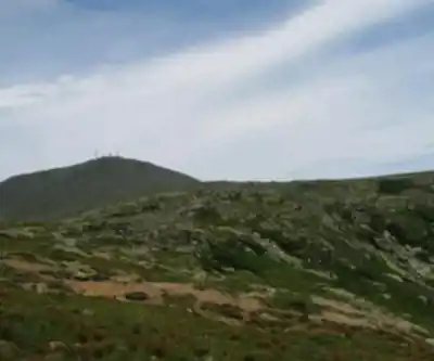
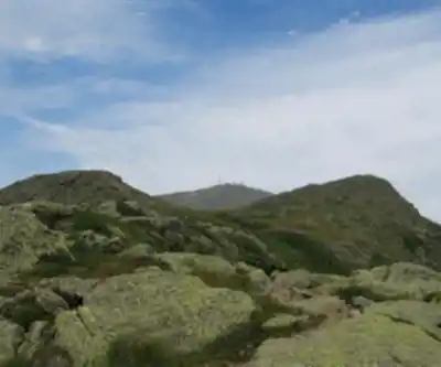
What sets Mount Monroe apart from other White Mountain peaks is its position above treeline in a genuine sub-arctic environment. The upper reaches exist in a tundra climate zone where weather can shift from pleasant to life-threatening within minutes, especially from late fall through early spring. This harsh environment creates one of the mountain's most distinctive features: Monroe Lawn, a largely flat expanse south of the summit that supports rare alpine vegetation, including the endangered Robbins Cinquefoil. The Crawford Path traverses this delicate ecosystem, and hikers must stay strictly on trail to protect the fragile flora that somehow thrives in this unforgiving landscape.
Trail Routes and Access
Mount Monroe offers no road access, making it a true hiking destination with several route options depending on your experience level and objectives. The most direct approach starts via the Ammonoosuc Ravine Trail, beginning near the Mount Washington Cog Railway base station to the northwest. This route takes you through a dramatic ravine characterized by numerous waterfalls and steep terrain scarred by occasional landslides. After the strenuous climb to Lakes of the Clouds Hut, you'll join the Crawford Path briefly before taking the Monroe Loop trail to the summit.
From the south, hikers can access Monroe via the Crawford Path starting at Crawford Notch, either as a standalone route or combined with the Edmands Path from Mount Clinton Road. Both approaches converge on the Monroe Loop for the final summit push. Eastern approaches offer more variety but require longer distances, utilizing combinations of the Boott Spur, Tuckerman Ravine, or Lion Head trails with connecting routes across the alpine zone.
Many hikers treat Mount Monroe as part of a larger Presidential Range traverse, commonly pairing it with Mount Washington, Mount Eisenhower, or both. The proximity to Mount Washington makes it particularly attractive for those who've reached the Northeast's highest peak by car or cog railway and want to add another 4000-footer to their day.
Terrain and Hiking Experience
The character of Mount Monroe changes dramatically with elevation. Lower sections follow typical White Mountain patterns with dense forest and rocky, root-filled trails. As you climb higher, the forest thins and eventually disappears entirely, leaving you exposed on the alpine zone where weather becomes the primary concern.
The mountain's steep walls on both the northwest and southeast sides create challenging ascents from valley floors, with elevation gains that will test your endurance. The Ammonoosuc Ravine route, while most direct, involves scrambling over wet rocks near waterfalls and navigating terrain that can be treacherous when icy.
Once above treeline, the landscape transforms into something more reminiscent of Alaska or northern Canada than New England. The Monroe Loop trail circles the summit, providing different perspectives and helping distribute foot traffic across this sensitive environment. The actual summit offers a relatively small area for groups, so timing your arrival during peak season requires patience.
Views and Notable Features
Mount Monroe's summit rewards hikers with some of the finest views in the Presidential Range. The perspective across Lakes of the Clouds to Mount Washington, towering over 900 feet higher to the northeast, provides one of the most photographed vistas in New England. To the north, Mount Jefferson and Mount Clay create an impressive skyline, while Boott Spur and Mount Isolation frame the view to the south.
The western views extend along the southern spine of the Presidential Range, down through the Dry River valley, and out to the broader White Mountains and distant Vermont peaks. On clear days, the 360-degree panorama justifies every challenging step of the ascent.
Beyond the main summit, Monroe includes several notable subsidiary peaks. Little Monroe sits about 175 feet lower to the west of the main peak, while Mount Franklin rises to nearly 5,000 feet southwest of the summit. These features add complexity to the mountain's profile and provide additional objectives for peak-baggers.
Weather and Safety Considerations
Mount Monroe's elevation and exposure create weather conditions that can be severe any time of year, but become particularly dangerous from late fall through early spring. The sub-arctic climate means temperatures can drop rapidly, winds can exceed hurricane force, and visibility can disappear in minutes. Even summer hikers should carry full winter gear including insulating layers, waterproof clothing, hat, gloves, and emergency shelter.
The combination of elevation, exposure, and technical terrain makes this a very challenging hike requiring solid fitness and mountain experience. Weather monitoring becomes critical for safe travel, and many experienced hikers turn back when conditions deteriorate rather than risk the exposed alpine sections.
The proximity to Lakes of the Clouds Hut provides some emergency shelter options, but the hut operates seasonally and may be full during peak periods. Self-sufficiency in gear and navigation skills remains essential for safe travel in this environment.
Recommended gear for this trail


Ready to go?
Everything you need to know before you goStarting Point
To access the hiking trails, you can start from several trailheads:
Ammonoosuc Ravine Trailhead: Located at the end of Base Station Road, near the Mount Washington Cog Railway. The address is 3168 Base Station Rd, Bretton Woods, NH 03589.
Jewell Trailhead: Also accessible from Base Station Road. Parking is available at the same lot used for the Ammonoosuc Ravine Trail.
Both trailheads are well-marked and provide parking facilities for hikers.
When?
How much?
- Hiking shoes Essential
- → Salomon Elixir Tour Mid WP · 203.38 $
- Layered clothing Essential
- Rain jacket Essential
- Trekking poles
- → Black Diamond Trail Ergo Cork · 69.99 $
- Headlamp
- → Petzl Actik Core 625 · 103.95 $
FAQ - Frequently asked questions
Everything you need to knowThe Essential Hiking Checklist
Everything you need for your next hike. Bilingual, printable, 1 page.
Download the free checklistSimilar hikes nearby
Discover other trails you might enjoy

Crawford
White Mountains
Presidential Range Rail Trail
White Mountains
Welch-Dickey Trailhead
White Mountains
Sabbaday Falls
White Mountains
Swift River
White Mountains
Mt Bond
White Mountains
Hiking near North Conway
0 trails to explore ~27 km away
We work hard to provide the most up-to-date and error-free data possible. If something seems incorrect, let us know! Your contribution helps the whole community.
Hikers' opinions