

Ready to explore Mount Moriah, New Hampshire? Here's everything you need to know before you go!
Discover the trail
Trail description
Description
Mount Moriah stands as one of the more remote and rewarding peaks in New Hampshire's White Mountains, offering hikers a challenging 16.1-kilometer journey through diverse terrain with 914 meters of elevation gain. This demanding trail typically takes around 5.5 hours to complete and ranks as a hard-difficulty hike, making it ideal for experienced hikers seeking a substantial mountain adventure away from the crowds.
Trail Experience and Terrain
The Mount Moriah trail takes you through a variety of landscapes that showcase the best of White Mountain wilderness. Starting from the trailhead, you'll begin with a moderate ascent through dense mixed forest, where the path winds steadily upward over well-maintained but rocky terrain. The initial sections provide a good warm-up for the more challenging climbs ahead.
As you gain elevation, the forest composition shifts noticeably. The lower elevations feature typical New England hardwoods mixed with conifers, while higher up, spruce and fir become dominant. The trail becomes increasingly steep in the middle sections, with some rocky scrambles that require careful footing, especially when wet.
One of the most distinctive features of this hike is the gradual transition from protected forest hiking to more exposed ridgeline terrain. The upper portions of the trail offer glimpses of the surrounding peaks through the trees, building anticipation for the summit views.
Summit and Views
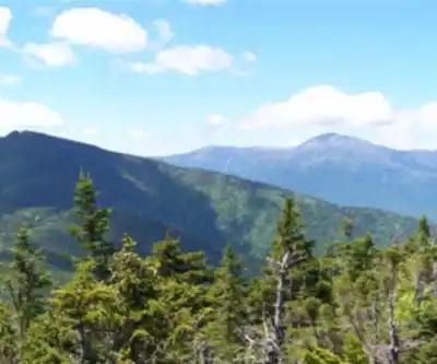
The summit of Mount Moriah rewards hikers with panoramic views that make the challenging ascent worthwhile. From the top, you can take in sweeping vistas of the surrounding White Mountain peaks and valleys. The views extend across the Presidential Range and other notable peaks in the region, providing excellent photo opportunities and a perfect spot for a well-earned rest.
The summit area itself is relatively open compared to many White Mountain peaks, offering multiple vantage points to enjoy the scenery. On clear days, the visibility extends for miles in all directions, showcasing the rugged beauty of New Hampshire's mountain landscape.
Trail Conditions and Seasonal Considerations
Mount Moriah presents different challenges throughout the hiking season. Spring conditions can include muddy sections and potential stream crossings that may be higher than usual due to snowmelt. The rocky sections of trail can be particularly slippery during wet conditions, so proper footwear with good traction is essential.
Summer hiking offers the most stable trail conditions, though the lack of significant tree cover near the summit means hikers should be prepared for potential weather changes. The exposed sections can be particularly challenging during thunderstorms, so early starts are recommended.
Fall brings spectacular foliage to the lower elevations, making this an excellent choice for leaf-peeping hikes. However, shorter daylight hours mean planning becomes even more critical given the trail's length and difficulty.
Wildlife and Natural Features
The diverse elevation range of the Mount Moriah trail supports a variety of wildlife typical of the White Mountains region. Hikers may encounter various bird species throughout the forest sections, and the changing forest composition provides habitat for different animals at various elevations.
The trail passes through several distinct ecological zones, from the mixed hardwood forests at lower elevations to the boreal forest characteristics of the higher reaches. This diversity makes the hike particularly interesting for those who enjoy observing changes in plant communities and forest structure.
Planning Your Hike
Given the trail's 16.1-kilometer length and significant elevation gain, proper preparation is crucial for a successful Mount Moriah hike. The estimated 5.5-hour duration assumes a steady pace with reasonable breaks, but hikers should plan for potentially longer times depending on conditions and fitness level.
Water is particularly important on this hike due to its length and difficulty. While there may be water sources along the route, it's safest to carry sufficient water for the entire journey. The exposed summit area offers little shelter, so layers and weather protection are essential regardless of starting conditions.
The remote nature of this trail means that hikers should be self-sufficient and prepared for changing conditions. Cell phone coverage may be spotty or nonexistent in many areas, so inform others of your hiking plans and expected return time.
What Makes Mount Moriah Special
Mount Moriah offers a quintessential White Mountains experience without the crowds found on some of the more popular peaks. The trail's length and difficulty level naturally filter out casual hikers, creating a more wilderness-like experience for those willing to take on the challenge.
The combination of diverse terrain, substantial elevation gain, and rewarding summit views makes this hike particularly satisfying for experienced hikers looking to test their endurance and skills. The sense of accomplishment upon completing this challenging trail is significant, and the memories of the varied landscapes and summit panoramas make it a hike that stays with you long after you've returned home.
Recommended gear for this trail


Ready to go?
Everything you need to know before you goStarting Point
To access the hiking trails, you can start at one of the following trailheads:
Stony Brook Trailhead: Located on Stony Brook Road in Gorham, NH. From Route 16 in Gorham, turn onto Promenade Street, which becomes Stony Brook Road. The parking area is about 2 miles down this road.
Carter-Moriah Trailhead: Situated at the end of Bangor Street in Gorham, NH. From Route 16 in Gorham, turn onto Main Street and then take a left onto Bangor Street. Follow it to the end where you'll find parking available.
Both trailheads provide access to different routes leading up to the trails.
When?
How much?
- Hiking shoes Essential
- → Salomon Elixir Tour Mid WP · 203.38 $
- Layered clothing Essential
- Rain jacket Essential
- Trekking poles
- → Black Diamond Trail Ergo Cork · 69.99 $
- Headlamp
- → Petzl Actik Core 625 · 103.95 $
FAQ - Frequently asked questions
Everything you need to knowThe Essential Hiking Checklist
Everything you need for your next hike. Bilingual, printable, 1 page.
Download the free checklistSimilar hikes nearby
Discover other trails you might enjoy

Crawford
White Mountains
Presidential Range Rail Trail
White Mountains
Welch-Dickey Trailhead
White Mountains
Sabbaday Falls
White Mountains
Swift River
White Mountains
Mt Bond
White Mountains
Hiking near North Conway
0 trails to explore ~32 km away
We work hard to provide the most up-to-date and error-free data possible. If something seems incorrect, let us know! Your contribution helps the whole community.
Hikers' opinions