

Ready to explore Owls Head, New Hampshire? Here's everything you need to know before you go!
Discover the trail
Trail description
Description
Owl's Head stands at 4,025 feet in Franconia, New Hampshire, occupying a unique position among the White Mountains' famous 48 four-thousand footers. This remote peak sits deep within the Pemigewasset Wilderness of the White Mountain National Forest, flanked by the Franconia Branch of the Pemigewasset River to the east and Lincoln Brook to the west and south. While it ranks 43rd in height among the 48 peaks, Owl's Head has earned a reputation that far exceeds its modest elevation.
What makes Owl's Head truly distinctive is what it lacks rather than what it offers. This is the only peak among the 48 four-thousand footers without an officially maintained trail to its summit. Instead, hikers must rely on an unofficial, unmaintained herd path that brings you within 0.2 miles of the top. The summit itself offers no views—thick forest canopy blocks any panoramic rewards that typically crown a mountain climb, except during rare occasions when deep snow weighs down the branches enough to create openings.
The Approach and Terrain
The journey to Owl's Head covers approximately 17.3 miles round trip with 4,025 feet of elevation gain, making it one of the longer slogs in the White Mountains. The mountain's isolation stems from natural barriers on all sides: the East Branch of the Pemigewasset River separates it from the Kancamagus Highway to the south, while Franconia Ridge's steep eastern face blocks western approaches from Interstate 93. To the north, Garfield Ridge creates another barrier from U.S. Route 3, and the Twin Range and Willey Range prevent easy access from U.S. Route 302 to the east.
Most hikers approach via the Lincoln Woods Trail, following the Franconia Brook Trail deep into the wilderness. The initial miles roll along relatively flat terrain on old railroad grades, lulling you into a false sense of the challenge ahead. The real work begins when you leave the maintained trail system and pick up the herd path. This unofficial route climbs steadily through dense forest, offering little in the way of landmarks or reassuring trail markers.
The unmaintained path can be challenging to follow, particularly during leaf-off seasons or after fresh snowfall. Hikers need solid navigation skills and should expect to do some route-finding. The trail becomes more defined as you gain elevation, worn smooth by the boots of countless peak-baggers, but it remains rough and occasionally obscure.
The Owls Head Slide
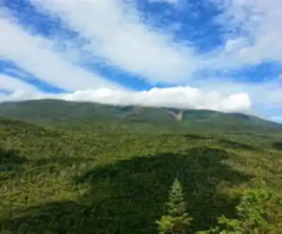
One of the few visual rewards on this hike comes from the Owls Head Slide, encountered while ascending the unmaintained path. This rocky opening provides welcome views across the wilderness—a stark contrast to the otherwise viewless summit experience. The slide offers a chance to catch your breath, take photos, and remind yourself why you're spending an entire day pursuing this remote peak.
The slide area requires some basic scrambling skills, though nothing technically difficult. Rock can be slippery when wet, and ice conditions in winter make this section particularly challenging. Many hikers find the slide views to be the highlight of their Owl's Head experience, since the summit itself offers no visual payoff.
Summit Confusion
Adding to Owl's Head's quirky character is the summit confusion discovered in fall 2005. The traditional summit reached by the beaten path turned out to be a false peak, with the true high point located approximately 0.2 miles north along the ridgeline. For practical purposes, the 4,000-footer committee continues to accept climbs to the false summit, sparing hikers the additional bushwhacking required to reach the actual highest point.
This summit mix-up perfectly captures Owl's Head's contrary nature—even when you think you've conquered it, the mountain holds back one final secret. Most hikers stick with the traditional false summit, which provides the same viewless, tree-covered experience as the true peak.
Planning Your Visit
The typical hiking time ranges from 8 to 12 hours, making this a serious full-day commitment. Start early, particularly during shorter winter days, and bring more food and water than you think you'll need. The long approach means you're committed once you start—there are no bail-out options or shortcuts.
Winter conditions add significant challenge and time to the journey. The unmaintained sections can become difficult to follow under snow, and the slide area may require microspikes or crampons. Snowshoes are essential for the final approach, and many winter hikers find this to be one of the more demanding cold-weather four-thousand footer experiences.
Because of its remote location and lack of views, Owl's Head receives disproportionately frequent honors as the final peak for hikers completing their 48 four-thousand footer list. There's something poetic about ending the quest on a mountain that embodies endurance over spectacle, effort over reward.
What to Expect
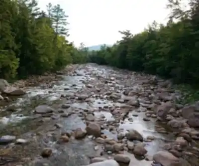
This hike is about the journey rather than the destination. You'll spend hours walking through beautiful wilderness terrain, crossing streams, and experiencing the deep quiet of the Pemigewasset Wilderness. The forest changes character as you gain elevation, from mixed hardwoods along the valley floor to the spruce and fir that dominate the higher elevations.
Wildlife sightings are possible throughout the wilderness area, including moose, black bear, and various bird species. The remote location means you're likely to encounter fewer people than on more popular White Mountain peaks, especially once you leave the maintained trail system.
Owl's Head demands respect for its length and remoteness rather than technical climbing skills. It's a test of determination and endurance, offering the satisfaction of completing a challenging wilderness journey even if the summit views don't match the effort invested.
Recommended gear for this trail


Ready to go?
Everything you need to know before you goStarting Point
To access the hiking trails, you can start at the Lincoln Woods Trailhead. The parking lot is located on the Kancamagus Highway (Route 112), about 5 miles east of Lincoln, NH. Another option is to begin at the Hancock Overlook parking area, also on the Kancamagus Highway, approximately 10 miles east of Lincoln. Both locations provide access to different trailheads leading into the area.
When?
How much?
- Hiking shoes Essential
- → Salomon Elixir Tour Mid WP · 203.38 $
- Layered clothing Essential
- Rain jacket Essential
- Trekking poles
- → Black Diamond Trail Ergo Cork · 69.99 $
- Headlamp
- → Petzl Actik Core 625 · 103.95 $
FAQ - Frequently asked questions
Everything you need to knowThe Essential Hiking Checklist
Everything you need for your next hike. Bilingual, printable, 1 page.
Download the free checklistSimilar hikes nearby
Discover other trails you might enjoy

Crawford
White Mountains
Welch-Dickey Trailhead
White Mountains
White Mountain National Forest
White Mountains
Presidential Range Rail Trail
White Mountains
Sabbaday Falls
White Mountains
Swift River
White Mountains
Hiking near North Conway
0 trails to explore ~39 km away
We work hard to provide the most up-to-date and error-free data possible. If something seems incorrect, let us know! Your contribution helps the whole community.
Hikers' opinions