

Ready to explore West Bond, New Hampshire? Here's everything you need to know before you go!
Discover the trail

Trail description
Description
West Bond Mountain stands at 4,540 feet (1,384 meters) in New Hampshire's White Mountains, forming part of an impressive trio with Mount Bond and Bondcliff. This isn't a standalone peak you can tackle quickly—reaching West Bond requires traversing all three summits in sequence, making it one of the more committing adventures in the region. The complete circuit covers approximately 22.4 miles (36 km) round trip with significant elevation gain, earning its classification as a very difficult hike that demands respect and preparation.
What sets this hike apart is the mandatory progression through three distinct summits, each offering its own character and challenges. You'll start with Bondcliff at 4,265 feet (1,300 meters), continue to Mount Bond at 4,698 feet (1,432 meters), and finally reach West Bond. This creates a unique alpine experience where you're rewarded with three separate 360-degree viewpoints instead of just one summit celebration.
The Trail Experience
Your journey begins at the spacious Lincoln Woods Visitor Center parking lot along the Kancamagus Highway. The initial approach follows a well-maintained path that crosses a 55-meter suspension bridge, leading you onto the Lincoln Woods Trail. This first 4.5-kilometer section follows an old railway grade once used for logging operations, providing relatively easy walking as you warm up for the challenges ahead.
The character of the hike changes dramatically when you transition to the Bondcliff Trail. Here, the real work begins with steep, sustained climbing punctuated by three creek crossings. The trail becomes increasingly rocky as you gain elevation, with the final approach to Bondcliff featuring exposed scrambling over granite slabs and ledges. There's even a small cliff section that becomes genuinely dangerous in wet conditions—this is where the trail earns its very difficult rating.
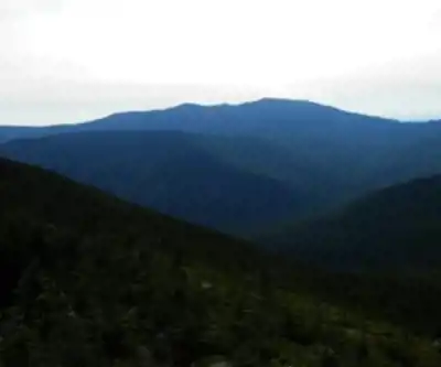
After 14 kilometers of effort, you'll reach Bondcliff's summit and its magnificent 360-degree panorama. The views stretch across the Pemigewasset Wilderness, with the presidential peaks visible on clear days. But this is just the first act of your mountain theater.
The Bond Traverse
From Bondcliff, the adventure continues along the same trail system toward Mount Bond. This 1.9-kilometer section introduces you to "The Bond's Knife Edge," a rocky ridge that provides some of the most dramatic terrain in the White Mountains. The narrow, exposed ridge demands attention and offers spectacular drop-offs on both sides, creating an alpine experience that rivals anything in New England.
Mount Bond's summit at 4,698 feet delivers another stunning viewpoint with its own distinct perspective of the surrounding wilderness. The landscape here feels surprisingly remote despite the trail's popularity, with vast stretches of unbroken forest extending in every direction.
The final push to West Bond requires following the trail to its intersection with the West Bond Spur Trail, then taking the left branch for about 800 meters. This last section often feels like the longest, as fatigue sets in and the summit seems to play hide-and-seek behind false peaks. When you finally reach West Bond's true summit, you're rewarded with exceptional views in all directions and the satisfaction of having completed one of New Hampshire's most challenging single-day hikes.
Planning Your Adventure
Allow approximately 12 hours to complete this round-trip trail, though strong hikers might finish faster and others may need more time. The distance and elevation gain make this a serious undertaking that requires good physical conditioning and mountain experience. Beginners should gain experience on shorter, less technical peaks before attempting this route.
Those with vertigo should seriously consider whether this hike is appropriate, as the exposed sections along the Knife Edge and the rocky scrambles can be intimidating. The trail's technical sections, combined with its length, create multiple opportunities for problems if you're not prepared.
Weather plays a crucial role in both safety and enjoyment. The exposed ridges become dangerous in storms, and the rocky sections can be treacherous when wet. Start early to avoid afternoon thunderstorms, and be prepared to turn back if conditions deteriorate.
Practical Information
The trail welcomes visitors year-round, though winter conditions require mountaineering skills and equipment. Snow and ice transform the already challenging terrain into expert-level territory, with the exposed ridges becoming particularly hazardous.
Parking at Lincoln Woods requires a fee, so bring cash or check current payment options. The lot fills up quickly during peak hiking season, especially on weekends, so arrive early or have backup plans.
Dogs are welcome on leash throughout the hike, though owners should carefully consider their pet's fitness level and ability to handle the rocky terrain and long distance. The creek crossings and exposed sections can be challenging for four-legged companions.
Water is available at the creek crossings along the Bondcliff Trail, but bring purification methods and carry more than you think you'll need. The long distance and physical demands increase hydration requirements significantly. Pack layers for changing weather conditions, especially above treeline where temperatures can drop quickly and wind exposure increases dramatically.
Recommended gear for this trail


Ready to go?
Everything you need to know before you goStarting Point
To access the hiking trails, you can start at the Lincoln Woods Trailhead. The parking lot is located on the Kancamagus Highway (NH-112), about 5 miles east of Lincoln, NH. Another option is the Zealand Trailhead, which can be found at the end of Zealand Road off US-302 in Bethlehem, NH. Both trailheads provide access to different routes leading to your destination.
When?
How much?
- Hiking shoes Essential
- → Salomon Elixir Tour Mid WP · 203.38 $
- Layered clothing Essential
- Rain jacket Essential
- Trekking poles
- → Black Diamond Trail Ergo Cork · 69.99 $
- Headlamp
- → Petzl Actik Core 625 · 103.95 $
FAQ - Frequently asked questions
Everything you need to knowThe Essential Hiking Checklist
Everything you need for your next hike. Bilingual, printable, 1 page.
Download the free checklistSimilar hikes nearby
Discover other trails you might enjoy

Crawford
White Mountains
Welch-Dickey Trailhead
White Mountains
White Mountain National Forest
White Mountains
Presidential Range Rail Trail
White Mountains
Sabbaday Falls
White Mountains
Swift River
White Mountains
Hiking near North Conway
0 trails to explore ~34 km away
We work hard to provide the most up-to-date and error-free data possible. If something seems incorrect, let us know! Your contribution helps the whole community.
Hikers' opinions