

Ready to explore Basin Mountain, New York? Here's everything you need to know before you go!
Discover the trail
Trail description
Description
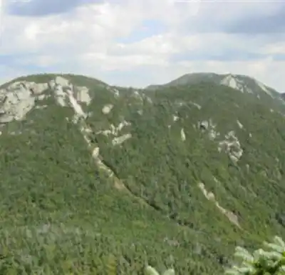
Basin Mountain stands as the ninth-highest peak in the Adirondack High Peaks Region, earning its name from Verplanck Colvin who noted the distinctive basins formed between rocky knobs scattered across its slopes. Located within the High Peaks Wilderness Area, this formidable summit anchors the eastern end of the legendary Great Range, offering hikers one of the most challenging and rewarding mountain experiences in New York State.
At 28.16 kilometers with 1,471 meters of elevation gain, Basin Mountain demands respect and thorough preparation. The difficulty rating of "very hard" reflects not just the physical demands but the technical terrain and sustained effort required over 6 to 8 hours of hiking. This isn't a casual day hike—it's a serious mountain adventure that tests endurance, navigation skills, and mental fortitude.
Route Options and Access
Basin Mountain can be approached from multiple trailheads throughout the Adirondacks, with routes passing near Upper Ausable Lake and along the State Range Trail. However, the shortest and most direct route begins at The Garden trailhead, located west of Keene Valley village. This access point serves as the gateway to some of the most spectacular alpine terrain in the Northeast.
For those seeking the ultimate Adirondack challenge, the complete Great Range traverse represents one of the most epic hikes in the region. This ambitious route starts at the Roostercomb Trailhead in Keene Valley and follows the entire spine of the Great Range. The traverse features extremely steep sections of exposed rock that demand careful foot placement and steady nerves. The combination of significant mileage and substantial vertical gain makes this best suited as an overnight expedition or an extremely demanding day trip with ultralight packs.
The Great Range Traverse Experience
The adventure begins with a climb to the junction below Roostercomb's summit, where hikers encounter a four-way intersection. This strategic location offers access to multiple peaks: a spur trail leads to Roostercomb itself, another branches toward Snow Mountain and the Ausable Valley, while the main route continues straight toward Hedgehog Mountain and the heart of the Great Range.
The side trips to Snow Mountain and Roostercomb shouldn't be missed, as both peaks feature excellent open rocky summits with panoramic views. These exposed granite slabs provide the first taste of the dramatic alpine terrain that characterizes the Great Range. The rock scrambling here serves as good preparation for the more challenging sections ahead.
After conquering Hedgehog Mountain and descending its far side, hikers reach what many consider the best camping area near Johns Brook Lodge. This historic backcountry facility serves as a crucial resupply and rest point, offering access to various trail networks including the Phelps Trail, which provides stunning vistas of Lake Placid and other iconic Adirondack landmarks.
The Technical Challenge
The second day of a Great Range traverse presents the most demanding hiking in the Adirondacks. The route ascends and crosses Lower Wolf Jaw, Upper Wolf Jaw, Armstrong, Gothics, Saddleback, and finally Basin Mountain itself. Each peak presents unique challenges, from the knife-edge ridges to the near-vertical rock faces that require scrambling skills and absolute focus.
The terrain between these summits varies dramatically, from dense boreal forest to completely exposed alpine zones. Weather can change rapidly above treeline, and the rocky surfaces become treacherous when wet. The sustained nature of this ridge walk—with multiple ascents and descents over technical terrain—creates cumulative fatigue that tests even experienced hikers.
For those continuing beyond Basin, the trail leads up and over Haystack Mountain to Panther Gorge, then climbs to Four Corners where both Skylight and Mount Marcy (New York's highest peak) become accessible. This extension adds significant time and difficulty to an already challenging route.
Extended Peak Bagging Opportunities
The Great Range's central location within the High Peaks region opens up numerous possibilities for additional summit collecting. Depending on your chosen exit trailhead and available time, accessible peaks include Gray, Redfield, Cliff, Colden, Allen, Phelps, Tabletop, Marshall, Iroquois, Algonquin, and Wright. However, attempting all these summits in addition to the complete Great Range traverse would create an expedition of extreme difficulty that only the most experienced and well-conditioned hikers should consider.
What Makes Basin Special
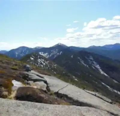
Basin Mountain's position at the eastern terminus of the Great Range provides unique perspectives on the surrounding wilderness. The summit offers commanding views back along the entire ridge system you've traversed, creating a powerful sense of accomplishment. The geological features that gave the mountain its name—those distinctive basins carved between rocky knobs—create interesting micro-environments and add visual complexity to the landscape.
The mountain's elevation and exposure mean weather conditions can be severe and change rapidly. Snow is possible even in summer months, and the exposed rock faces can become dangerously slippery. The combination of technical terrain and potential weather hazards makes Basin Mountain a serious undertaking that requires proper gear, experience, and judgment.
From Basin's summit, the view encompasses much of the High Peaks Wilderness, with the distinctive profiles of neighboring mountains creating a dramatic alpine panorama. On clear days, the vista extends far beyond the immediate peaks to include distant ranges and the patchwork of forests, lakes, and valleys that define the greater Adirondack landscape.
Recommended gear for this trail


Ready to go?
Everything you need to know before you goStarting Point
To access the hiking trails, you can start at the trailhead located at the end of Adirondack Loj Road. The parking area is at the Adirondack Mountain Club's High Peaks Information Center, with the address: 1002 Adirondack Loj Road, Lake Placid, NY 12946. Another option is to begin from the Garden Parking Lot in Keene Valley. The address for this location is: Garden Parking Lot, Johns Brook Lane, Keene Valley, NY 12943. Both trailheads provide access to different routes leading to your destination.
When?
How much?
- Hiking shoes Essential
- → Salomon Elixir Tour Mid WP · 203.38 $
- Layered clothing Essential
- Rain jacket Essential
- Trekking poles
- → Black Diamond Trail Ergo Cork · 69.99 $
- Headlamp
- → Petzl Actik Core 625 · 103.95 $
FAQ - Frequently asked questions
Everything you need to knowThe Essential Hiking Checklist
Everything you need for your next hike. Bilingual, printable, 1 page.
Download the free checklistSimilar hikes nearby
Discover other trails you might enjoy

Algonquin Peak, New York
Adirondacks

Big Slide Mountain, New York
Adirondacks

Boundary Peak, New York
Adirondacks

Crane Mountain
Adirondacks
Avalanche Pass
Adirondacks
Ampersand Mountain, New York
Adirondacks
Hiking near Lake Placid
0 trails to explore ~19 km away
We work hard to provide the most up-to-date and error-free data possible. If something seems incorrect, let us know! Your contribution helps the whole community.
Hikers' opinions