

Ready to explore Giant Mountain, New York? Here's everything you need to know before you go!
Discover the trail
Trail description
Description
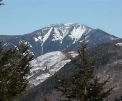
Giant Mountain is the twelfth-highest peak in the Adirondack High Peaks region of New York, standing as one of the most recognizable summits in the park. Known locally as the "Giant of the Valley," the mountain earns its nickname from the commanding presence it holds over Keene Valley and St. Huberts to the west. Its steep western face, marked by prominent rock slides, and its somewhat isolated position away from the main cluster of High Peaks give it a bold, imposing silhouette that's hard to miss from the valley floor.
This is a serious mountain. With 1,410 meters of elevation gain packed into 5.2 kilometers, Giant Mountain demands respect and solid preparation. The estimated 4.5-hour round trip is a realistic target for fit hikers moving at a steady pace, but the relentless grade — especially on the steeper western approaches — means this trail earns its "very hard" rating. Don't let the relatively short distance fool you.
Trail Options
There are three main routes up Giant Mountain, each offering a different experience depending on where you're starting from and what you want to see along the way.
The two most popular approaches begin off New York State Route 73 on the western side of the mountain:
- Roaring Brook Trail — Starting near St. Huberts, this is the longer of the two western routes but slightly more gradual in its early sections. It climbs the southern ridge of the mountain.
- Zander Scott Trail — Beginning near Chapel Pond, this route is shorter but noticeably steeper. It also climbs the southern ridge and meets up with the Roaring Brook Trail roughly a mile south of the summit.
Both western trails converge before the final push to the top, so you can mix and match for a loop if you have a shuttle or a willing hiking partner to spot a car at each trailhead.
The North Trail offers a less-traveled alternative through dense forest and rugged terrain. This route connects with the Ridge Trail and passes near Roaring Brook Falls, giving hikers a different perspective on the mountain's character. It's a solid option for those who want to link up with other trails in the area and explore more of the surrounding terrain.
The Eastern Approach: Rocky Peak Ridge Route
The third option comes from the east, starting near the town of New Russia. This is a longer, less-traveled route that sees fewer hikers, partly because of the added distance and partly because it requires more planning. The trail climbs Bald Peak first — a smaller summit notable for its unusual krummholz vegetation, predominantly Northern White Cedar (Thuja occidentalis) — before continuing up to Rocky Peak Ridge. From there, hikers descend a small col before making the final ascent to Giant's summit.
This eastern route is particularly popular among hikers working toward the Adirondack Forty-Sixers designation, since Rocky Peak Ridge is one of the required peaks on that list. If you're chasing the 46, this route lets you knock off two summits in a single outing.
What to Expect on the Climb
Regardless of which route you choose, Giant Mountain is a physically demanding day. The western trails in particular throw sustained steep sections at you early and don't let up much until you're near the top. The terrain is rocky and rooted throughout, with some sections requiring hands-on scrambling as you gain elevation.
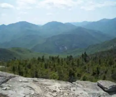
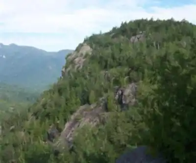
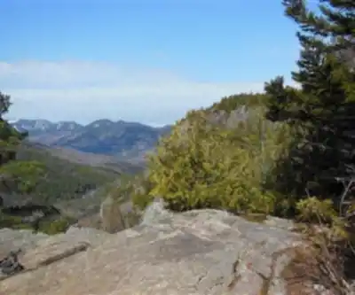
The rock slides on the western face are a defining feature of this mountain — you'll likely see them from the valley before you even start hiking, and you'll get a much closer look as you climb. Above treeline, the views open up significantly, and the summit offers wide-ranging panoramas across the Adirondack High Peaks and down into the valleys below.
The eastern route via Rocky Peak Ridge adds considerable mileage and complexity, with multiple summits and a descent between ridges that can feel punishing on tired legs. Plan accordingly and give yourself extra time if you're heading that way.
Practical Information
The main trailheads for the western routes are accessible from Route 73 in the Keene Valley and St. Huberts area. Parking at Adirondack trailheads can fill up quickly on weekends, especially during peak season, so an early start is strongly recommended — both for parking and for giving yourself enough daylight to complete the hike comfortably.
Bring plenty of water, as there are limited reliable water sources on the upper mountain. Trekking poles are useful given the steep and rocky terrain, particularly on the descent. Weather in the Adirondacks can change quickly at elevation, so pack a layer and a rain shell regardless of the forecast.
Giant Mountain sits within Adirondack Park, and the trails are maintained as part of the New York State Forest Preserve. Leave No Trace principles apply throughout, and staying on marked trails is especially important in the fragile alpine zone near the summit.
Services and amenities
This information may vary by season.
Recommended gear for this trail


Ready to go?
Everything you need to know before you goStarting Point
To access the hiking trails, you can start at several trailheads:
Chapel Pond Trailhead: Located on Route 73, approximately 3 miles south of Keene Valley. Parking is available along the road near Chapel Pond.
Roaring Brook Trailhead: Situated on Route 73, about 4 miles south of Keene Valley. There is a designated parking area for hikers.
Ridge Trailhead (AMR): Found at the Adirondack Mountain Reserve (AMR) parking lot on Ausable Road, off Route 73 in St. Huberts. Note that this area requires a reservation to park.
Each trailhead provides different routes to reach your destination, so choose based on your preferred hiking experience and availability of parking.
When?
How much?
- Hiking shoes Essential
- → Salomon Elixir Tour Mid WP · 203.38 $
- Layered clothing Essential
- Rain jacket Essential
- Trekking poles
- → Black Diamond Trail Ergo Cork · 69.99 $
- Headlamp
- → Petzl Actik Core 625 · 103.95 $
FAQ - Frequently asked questions
Everything you need to knowThe Essential Hiking Checklist
Everything you need for your next hike. Bilingual, printable, 1 page.
Download the free checklistSimilar hikes nearby
Discover other trails you might enjoy

Algonquin Peak, New York
Adirondacks

Big Slide Mountain, New York
Adirondacks

Boundary Peak, New York
Adirondacks

Crane Mountain
Adirondacks
Avalanche Pass
Adirondacks
Ampersand Mountain, New York
Adirondacks
Hiking near Lake Placid
0 trails to explore ~25 km away
We work hard to provide the most up-to-date and error-free data possible. If something seems incorrect, let us know! Your contribution helps the whole community.
Hikers' opinions