

Ready to explore Sleeping Beauty Mountain Trail? Here's everything you need to know before you go!
Discover the trail

Available trails
| TrailTrails | Dist.Distance | GainElevation | TimeDuration | Difficulty | GPX |
|---|---|---|---|---|---|
|
|
2.98 km | — | 40min | GPX |
GPX track: © OpenStreetMap contributors — ODbL 1.0
Trail description
Sleeping Beauty Mountain Trail is one of those hikes in the Adirondacks that earns its reputation through a genuine climb, real forest, and a summit view that makes the effort feel completely worth it. Located in the Lake George Wild Forest in New York, this trail draws hikers looking for a rewarding day out without needing to tackle one of the High Peaks.
The Hike
The trail covers approximately 2.4 to 4.2 km round trip (1.8 to 2.6 miles), with an elevation gain of 381 meters (1,250 feet). Plan on spending 1 hour 50 minutes on average, though that can vary depending on your pace and how long you linger at the top. The terrain moves through classic Adirondack hardwood and mixed forest before opening up onto the rocky summit ledges that define Sleeping Beauty Mountain.
The ascent is steady and moderate. You'll gain elevation gradually through the lower sections via a broad tote road from Dacy Clearing, with the trail becoming rockier and more exposed as you approach the top through a series of switchbacks. The upper portions require attention to footing, especially on wet days, but the hike is accessible without being trivial.
The Summit
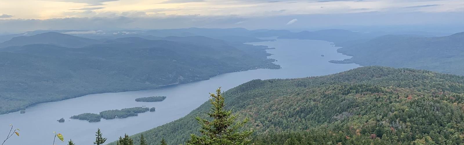
The payoff at the top is a panoramic view over Lake George and the surrounding Adirondack Mountains, including views toward the Green Mountains of Vermont. On a clear day, the lake stretches out below you in a way that's hard to fully appreciate until you're standing there. The open ledges give you room to spread out, eat lunch, and take in the view without feeling crowded — at least outside of peak weekends.
The summit area has that raw, open-rock character that's typical of Adirondack peaks: no observation tower, no infrastructure, just the mountain and the view. Bring your camera, but also just take a few minutes to sit with it.
Getting There
The trailhead is accessed via Dacy Clearing Road. Parking is available at the trailhead, but it fills up fast on summer weekends and fall foliage weekends. Getting there early — before 9 a.m. on busy days — is a good habit. Note that the gate at the entrance of Dacy Clearing Road is sometimes closed, so check conditions before your visit.
When to Go
Late spring through early fall is the sweet spot. The trail is accessible year-round, but late spring brings mud season in the Adirondacks, so expect soft, wet conditions on the lower sections until things dry out — usually by late May or early June. Fall is spectacular for foliage, and the views from the summit take on a whole different character when the hardwoods turn. Winter hiking is possible for those with the right gear and experience, but the upper rocky sections can be icy and require traction devices.
What to Bring
- Water: Carry more than you think you need. There's no reliable water source on the trail that you should count on without a filter.
- Footwear: Sturdy hiking boots with ankle support are the right call here. Trail runners work for experienced hikers, but the rocky upper sections reward a boot with grip.
- Layers: Summit temperatures in the Adirondacks can be noticeably cooler than the trailhead, even in summer. A light layer in your pack is always smart.
- Snacks and lunch: The summit is a great place to eat. Pack something worth sitting down for.
- Navigation: Download an offline map or bring a paper topo. Cell service in the Lake George Wild Forest is unreliable.
Leave No Trace
The Lake George Wild Forest sees significant use, and Sleeping Beauty Mountain is one of its more popular destinations. Pack out everything you bring in, stay on the marked trail to protect the vegetation on the summit ledges, and keep noise levels reasonable — other hikers are out there for the same quiet you're looking for.
Sleeping Beauty Mountain Trail is the kind of hike that fits a wide range of hikers: accessible enough for someone newer to the trails, satisfying enough for regulars who know what a good Adirondack summit feels like.
The Essential Hiking Checklist
Everything you need for your next hike. Bilingual, printable, 1 page.
Get your free hiking checklistRecommended gear for this trail
As an Amazon Associate I earn from qualifying purchases.


Ready to go?
Everything you need to know before you goStarting Point
The sleeping beauty mountain trail is located in the town of Tuxedo, New York. To get to the start of the trails, take exit 15A off of the Palisades Parkway and head east on Route 17. Take the first exit (Tuxedo) and turn left at the light. Go straight through the next light and make a right onto Route 17A. The entrance to the park will be on your left in about 1.5 miles.
When?
How much?
As an Amazon Associate I earn from qualifying purchases.
Affiliate links — LGPO may earn a commission at no extra cost to you.
- Hiking shoes Essential
- → Salomon Elixir Tour Mid WP · 203.38 $
- Layered clothing Essential
- Rain jacket Essential
- Trekking poles
- → Black Diamond Trail Ergo Cork · 69.99 $
- Headlamp
- → Petzl Actik Core 625 · 103.95 $
FAQ - Frequently asked questions
Everything you need to knowSimilar hikes nearby
Discover other trails you might enjoy

Algonquin Peak, New York
Adirondacks

Big Slide Mountain, New York
Adirondacks

Boundary Peak, New York
Adirondacks
Crane Mountain
Adirondacks
Avalanche Pass
Adirondacks
Ampersand Mountain, New York
Adirondacks
Hiking near Saratoga Springs
0 trails to explore ~56 km away
We work hard to provide the most up-to-date and error-free data possible. If something seems incorrect, let us know! Your contribution helps the whole community.
Hikers' opinions
Be the first to review!
No hiker has shared their experience yet. Share your impressions and help other hikers!