
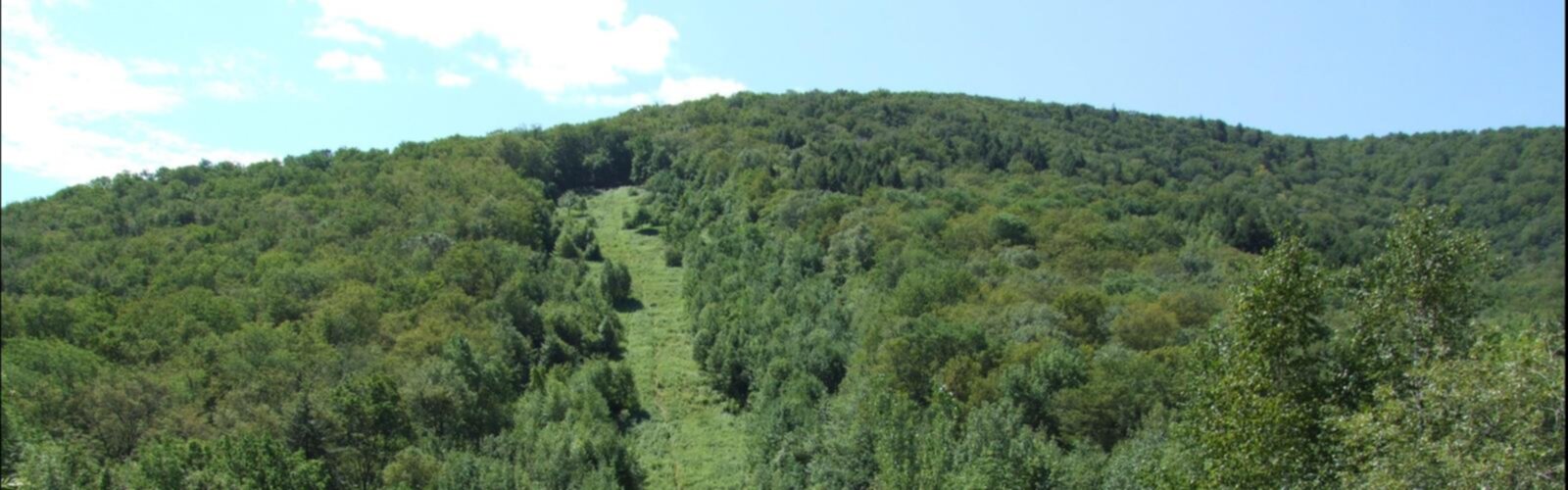

Ready to explore Berlin Mountain, New York? Here's everything you need to know before you go!
Discover the trail
Trail description
Berlin Mountain tops out at 2,818 feet as the highest peak in Rensselaer County, and it earns that distinction with a hike that genuinely challenges you. At 8.69 km round trip with 859 meters of elevation gain, this is a serious day out — rated very hard for good reason, with an estimated 3.5 hours of moving time that doesn't account for breaks at the summit. What you get in return is one of the most expansive summit views in the Capital-Saratoga region, with sight lines reaching into Massachusetts and Vermont on a clear day.
The mountain sits along the Taconic Range, right where New York pushes up against its eastern neighbors. That border position matters for the views — Berlin Mountain stands prominently above the surrounding terrain rather than being crowded by neighboring peaks of similar height, which means the panoramas feel genuinely open and far-reaching.
Getting to the Trailhead
The main access point is Petersburg Pass on Route 2, where the Taconic Crest Trail crosses the road. The trailhead is straightforward to find, and the Taconic Crest Trail is the established route to the summit. This is a well-used trail corridor, so signage is generally reliable, but bring a map regardless — the terrain gets more complex as you gain elevation.
What the Climb Actually Feels Like
The first stretch from Petersburg Pass moves through dense hardwood forest — maple, birch, and oak dominate the lower slopes. The climbing starts immediately but stays manageable for the first mile or so, with a steady grade that lets you find your rhythm. The forest canopy keeps things shaded and cool during summer, though it also means you're hiking without views for a good portion of the ascent.
The middle sections are where the trail gets serious. Several steep pitches require real effort and careful footing, especially on wet rock. The terrain alternates between rocky outcrops and softer forest floor, and this is where most of the elevation gain happens. There's no shortcut through this section — you just have to work through it. Trekking poles are genuinely useful here, both on the way up and particularly on the descent when tired legs meet steep, rocky ground.
As you push into the upper elevations, the forest begins to open. The tree cover thins and the character of the trail shifts — you start getting glimpses of sky and distant ridgelines through the trees before the trail breaks out into the meadow areas near the summit. These transition zones are worth slowing down for, both for the views that start opening up and for the wildlife activity that concentrates in these edge habitats.
The Summit
Berlin Mountain's summit delivers a genuine 360-degree panorama that justifies every steep pitch on the way up. To the west, the Hudson River Valley spreads out below, with the river itself visible on clear days and the Adirondack foothills stacking up in layers toward the horizon. The Catskill Mountains form a recognizable profile to the south.
The eastern views are particularly striking — Mount Greylock in Massachusetts rises clearly above the Berkshire Hills, and on days with exceptional visibility, you can follow the Green Mountain ridgeline north into Vermont. For a peak that sits just under 3,000 feet, the geographic reach of these views is remarkable, a direct result of Berlin Mountain's prominence above the surrounding landscape.
The summit area has multiple vantage points, so you can move around to find the best angle or get out of the wind if conditions are breezy. The open, meadow character of the top makes it a good place to spend time rather than just tag the summit and turn around.
Wildlife and Natural Character
The elevation change along this route creates genuinely distinct habitat zones. The lower hardwood forest supports typical northeastern woodland species, while the meadow areas near the summit attract different bird communities — the transition zones between these habitats are particularly productive for birdwatchers, especially during spring and fall migration when the mountain's elevation makes it a natural waypoint for traveling species.
The forest composition shifts noticeably as you gain altitude, with the plant communities adapting to increased exposure and cooler temperatures. The summit meadows represent a distinct ecosystem from the dense canopy below, and that contrast is part of what makes the hike feel like a complete experience rather than just a slog to a viewpoint.
Planning Your Visit
With 859 meters of elevation gain over 8.69 km, water management matters on this hike. Carry more than you think you need — the sustained climbing and exposed summit both increase fluid requirements, and there are no reliable water sources on the route.
Layering is important. The temperature difference between the trailhead and summit can be significant, and the open summit is exposed to wind that doesn't affect the sheltered forest sections below. A wind layer in your pack is worth the weight even on days that feel warm at the car.
Footwear with solid traction is non-negotiable given the steep, rocky sections in the middle of the route. The trail can be slippery when wet, and the descent on tired legs demands grip you can count on.
Fall is the standout season for this hike — the hardwood forests put on a serious color display, and the cool, clear air of autumn typically delivers the best long-distance visibility from the summit. Summer works well too, though afternoon thunderstorms can build quickly at this elevation, making an early start a smart habit. Spring brings mud and the possibility of lingering snow on north-facing slopes, so check conditions before heading out. Winter is possible for experienced hikers with appropriate gear, but the exposed summit can see severe wind and weather that demands careful judgment about when to turn around.
Stay on the established Taconic Crest Trail throughout, pack out everything you bring in, and give the summit meadow ecosystem the same respect you'd give any fragile high-elevation environment.
The Essential Hiking Checklist
Everything you need for your next hike. Bilingual, printable, 1 page.
Get your free hiking checklistRecommended gear for this trail
As an Amazon Associate I earn from qualifying purchases.


Ready to go?
Everything you need to know before you goStarting Point
To access the hiking trails, you can start at the Petersburg Pass parking area. The address is Route 2, Petersburg, NY 12138. This location serves as a common trailhead for hikers heading to the summit.
When?
How much?
As an Amazon Associate I earn from qualifying purchases.
Affiliate links — LGPO may earn a commission at no extra cost to you.
- Hiking shoes Essential
- → Salomon Elixir Tour Mid WP · 203.38 $
- Layered clothing Essential
- Rain jacket Essential
- Trekking poles
- → Black Diamond Trail Ergo Cork · 69.99 $
- Headlamp
- → Petzl Actik Core 625 · 103.95 $
FAQ - Frequently asked questions
Everything you need to knowSimilar hikes nearby
Discover other trails you might enjoy

Misery Mountain
Capital-Saratoga
Bauer Park
Capital-Saratoga
John Boyd Thacher State Park
Capital-Saratoga
Spier Falls/ Moreau "Saddle" Trailhead
Capital-Saratoga
Lake Bonita Trailhead
Capital-Saratoga
Colonie Town Park Trail Head
Capital-Saratoga
Hiking near Albany
0 trails to explore ~39 km away
We work hard to provide the most up-to-date and error-free data possible. If something seems incorrect, let us know! Your contribution helps the whole community.
Hikers' opinions
Be the first to review!
No hiker has shared their experience yet. Share your impressions and help other hikers!